Understanding shoreline change and sea-level rise: what it means for adaptation of coastal infrastructure

1. Introduction
Coastal communities globally face the unprecedented task of adapting to elevated coastal hazard risk under changing environmental conditions, including sea-level rise. Sea-level rise will continue for centuries, and while the rate of future sea-level rise is uncertain, there will undoubtedly be an increase in the intensity of extreme erosion and flooding events, and increasingly a succession of nuisance events. The ‘gradual onset’ risk that results from the changing and cumulative impact of long-term coastal hazards presents a profound challenge for coastal communities, infrastructure and local government. In New Zealand, sea level is expected to rise, on average, between 0.55 and 1.3 m over the next 100 years (MfE, 2017), depending on future global emissions reduction and the response of polar ice sheets. Despite uncertainties in the rate and extent of future sea-level rise, it is clear that New Zealand’s risk exposure of assets and natural coastal environments is rapidly increasing as sea-level rise accelerates and a legacy of poor coastal planning decisions takes effect, including development of buildings and infrastructure on naturally dynamic coastal margins. A national-scale screening assessment of coastal flooding exposure (Bell et al., 2015) highlighted that while a small proportion (0.6%) of New Zealand’s land area is low-lying (within 3 m elevation of spring high tides), these low-lying coastal areas account for 6–7% of New Zealand’s building replacement costs and at least $14 billion of local government assets, including transport and three waters infrastructure. A recent detailed assessment of storm-tide flooding has shown that much of New Zealand’s risk occurs within the first metre of sea-level rise, with 125,602 buildings and population of 177,646 potentially exposed to extreme storm-tide water levels (at 1% annual exceedance probability or equivalent to a 1/100 year event) (Paulik et al., 2020). This poses a significant adaptation challenge: coastal managers and infrastructure operators throughout New Zealand need to grapple with how to plan for, and adapt to, changing coastal hazard risk in different local contexts.
Despite updated guidance on coastal hazards and climate change published by the Ministry for the Environment in 2017 (MfE, 2017), councils across New Zealand remain embedded in management practices and options that focus on defending property/assets from damaging events as well as responding to and cleaning-up the effects of these events. This approach partly reflects the demands of coastal communities, but will not be sustainable in low-lying areas in the face of ongoing sea-level rise. Management practices have traditionally focused on the recognition of coastal hazards, exemplified by the designation of coastal hazard zones (and lines), rather than planning on how land use should be progressively adapted to avoid coastal hazards. Even so, coastal councils face institutional and funding challenges in implementing more adaptive planning options, as illustrated recently for the Hawke’s Bay coastal strategy (MfE and Hawke’s Bay Regional Council partnership project, 2020).
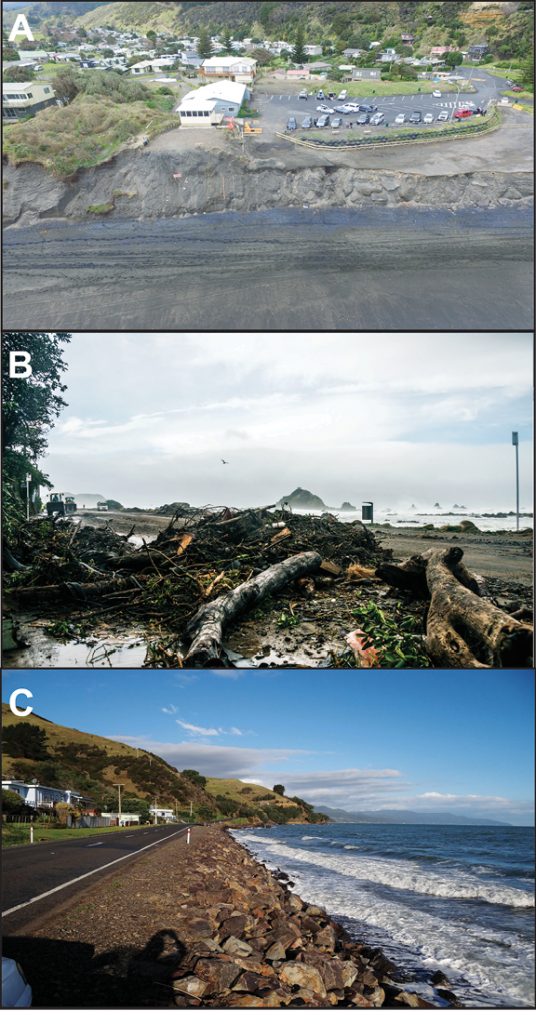
Photo: Different coastal adaptation approaches will be required in different local contexts: Photo A) shows Port Waikato in 2015, before the community building was completely removed (Credit: T. Shand); Photo B) shows storm surge impacts on Wellington’s south coast in June 2013 (Credit: D. Allen, NIWA). Photo C) shows a low-lying exposed road on the Thames coastline (Credit: T. Shand).
Coastal erosion can be exacerbated by climate-change effects, but there are multiple natural and human effects that muddy efforts to understand the link between sea-level rise and shoreline change. In addition, councils and infrastructure operators are limited by fragmented, inconsistent baseline data about how shorelines have changed in the past and are trending presently. Around New Zealand, work on coastal change has been undertaken on an ad-hoc basis, without a consistent approach to data collection and analysis, sometimes spanning timescales that are misaligned with hazard planning and management goals. This means that despite pressing need, local government remains poorly resourced to implement data-driven coastal adaptation strategies in the face of irreversible sea-level rise.
The Coastal Theme within the Resilience to Nature’s Challenges National Science Challenge (“Resilience Challenge”) aims to directly address this problem. Established in 2015, the Resilience Challenge is one of New Zealand’s 12 National Science Challenges. It tackles the big questions about how to build resilience to natural hazards including rare, high-impact hazards such as earthquakes, volcanic eruptions and extreme weather events; but also considers gradual-onset hazards, such as coastal erosion and sea-level rise. In this article we introduce the ongoing work within the Coastal Theme and highlight aspects of the research that will be of most relevance to the New Zealand Geotechnical Society, particularly for those working or with interests, in the coastal environment that will be impacted by relative sea-level rise and other climate-change effects (e.g. waves, river flow, sediment supply).
2. Overview of the Coastal Theme research
The Coastal Theme within the Resilience Challenge is a five-year project (2019–2024) that aims to develop and implement new, nationally consistent approaches to tackle NZ’s current and future coastal hazards and better enable adaptation at the coast. The Coastal Theme forms part of the second funding round of the Resilience Challenge and builds on research completed in the ‘Living at the Edge’ project (2016-2019) as part of the first Resilience Challenge funding round. The ‘Living at the Edge’ project was focused on building resilience to coastal hazards in a local/regional setting in New Zealand (Hawke’s Bay). The Coastal Theme now aims to expand the knowledge gained to national scale and engage with stakeholders around the country in developing new approaches to coastal adaptation. The Coastal Theme comprises three complementary research ‘Pillars’, each of which will generate new science to support hazard identification, risk assessment and enable more effective coastal adaptation.
The three pillars of research are:
One: NZ’s Changing Coastline
- To explore how New Zealand’s coastline has changed over the past 70 years and what this means for future coastal change projections
Two: Coastal Flooding
- To better understand and model New Zealand’s coastal flood hazards, particularly in estuarine system
Three: Enabling Proactive Coastal Adaptation
- To generate new nationally consistent methods, frameworks and tools for coastal adaptation and vulnerability/risk assessments
Together, the three research pillars will: map past and present physical changes in New Zealand’s coastline (erosion/accretion/stability); determine current and future changes in coastal flooding risk in low-lying areas and estuaries; identify hotspots of coastal risk exposure around New Zealand; and develop consistent, proactive national approaches for understanding past and future coastal change and assessing coastal hazard exposure and vulnerability. Importantly, these new approaches and datasets will be nationally consistent as befits the “new normal” of changing risk associated with ongoing sea-level rise. A new suite of coastal hazard adaptation methodologies and adaptive planning options and economic evaluation tools will be developed that are locally suited, cost-effective, and can be practicably implemented. These will be delivered through improved national guidance and codes of practice that management agencies and practitioner groups can use to address the pressing coastal adaptation challenge. Collectively, these outputs will provide the scientific data, insight and enablers necessary to inform a coastal hazard management strategy for New Zealand for the next 50-100 years and beyond. Next, we highlight three examples of research ongoing in Pillars 1 and 3 of the Resilience Challenge Coastal Theme.
Photo: Very high resolution (30-50 cm) satellite imagery used to determine rates of shoreline change around NZ. Example shows 50 m of coastal erosion near Westport Airport between 2005 and 2020.

3. Transforming New Zealand’s coastal change detection
Limitations with existing data collection practices make it difficult for scientists and coastal managers to understand patterns and drivers of coastal change around New Zealand and implement relevant management options. Research in Pillar 1 will fundamentally change the way that past, present and future coastal change is detected and understood in New Zealand. We are developing and applying cutting-edge remote sensing and geospatial tools to transform our understanding of past and present coastal change and provide the scientific datasets necessary for future-casting physical coastal change. This section provides an overview of our approach and current methodology and presents insights into future research outcomes.
In 2019 we engaged with LINZ and began a programme to compile historical, mapping-quality, aerial photographs of New Zealand’s coast. Detailed and consistent protocols for image acquisition, georectification, and shoreline mapping have been developed with the overall goal of producing a nation-wide database of historical shoreline data for open-coast soft sedimentary beaches (>50 m in length). In addition to the historical imagery data, we are making use of recent advances in Earth Observation (EO) satellite imagery that provides new opportunities to transform the way coastal change is assessed. The proliferation of commercial and government EO satellites provides opportunities to examine coastal change at spatial and temporal scales previously inaccessible to researchers. We are developing new geospatial methods within a cloud computing framework for detecting and analysing high-frequency coastal change over the past twenty years using imagery from Landsat and Sentinel 2 satellites, along with commercial satellites. Machine-learning and edge detection algorithms will be used to statistically determine the shoreline and map national-scale coastal change.
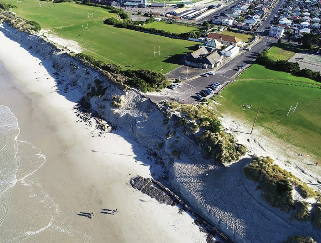
Photo: The response and recovery of coasts eroded during storm events depends in large part on the response of dune vegetation to the event and the ability of plants to recolonise the post-storm landscape (St Clair Beach, Dunedin, 18th August 2019).
After developing rates, styles and magnitudes of historical and recent shoreline change across the country, erosion and accretion hotspots will be identified. The relative contributions of different drivers of change to these observed shoreline changes will be explored. This is a key question for underpinning future projections of shoreline change and for making informed management decisions. Pillar One involves six researchers from across the country and three PhD projects (two at the University of Auckland and one at the University of Otago). Ultimately, we aim to fundamentally transform NZ’s shoreline change detection from small-scale, sporadic and manual monitoring to national-scale, semi-automated analyses in near real time. This means that councils around New Zealand will have access to consistent, up-to-date shoreline change data that can be meaningfully used in decision making around management and adaptation options. Datasets produced will also facilitate new research into understanding the multiple drivers of shoreline change (e.g. distinguishing the effects of human modification of the environment, natural changes in sediment supply, sea-level change and changes in coastal vegetation).
Coastal vegetation has been largely ignored in past analyses of shoreline dynamics and future change models. Coastal foredunes, the dune immediately behind sandy beaches, exist because of the sand-trapping function of a few plant species, and the future evolution of these dunes depends on the response of vegetation to increased scarping, inundation, erosion and burial. This work has commenced with a consideration of how foredunes have responded to the widespread establishment of marram grass, which at many sites in southern New Zealand has resulted in coastal progradation and foredune accretion. How will such foredunes respond to climate change pressures compared to native species – pngao and spinifex – which are more widespread in northern New Zealand? Will foredunes roll back into the hinterland, remain in place but be progressively scarped and eroded (to the point of total loss); or evolve in some other way? Key to this work is understanding how these three plant species trap sand; understanding the morphodynamics of different types of foredune; and determining how they may release sand under different disturbance regimes. The goal is to identify the biogeomorphic processes that determine the shape and dynamics of foredunes, and to model the response of foredunes to degrees of vegetation disturbance. This work will integrate with the work streams described above by providing estimates of the future response of different classes of sandy coast to environmental disturbance.
4. Adaptation of coastal infrastructure
Just over 1% of New Zealand’s road (1414 km) and rail (87 km) networks are exposed to present-day storm-tide and wave flooding, with further exposure of around 145 km of road per 0.1 m increment of the first metre of sea-level rise (Paulik et al., 2020). This poses an emerging challenge for central government transport agencies. Many local roads, which are managed by local government and provide vital connections to coastal communities, are also exposed to coastal hazard risk. Coastal roads are often co-located with other infrastructure networks, and in many local communities, coastal roads provide a buffer for the communities directly behind them. Structures intended to protect coastal infrastructure from hazards, including coastal erosion and inundation (such as sea walls, revetments, etc), are typically designed for specific and rare ‘extreme’ events, but their performance over time under gradual-onset coastal hazards associated with the uncertain rate of sea-level rise is less well understood. As part of Pillar 3 of the Coastal Theme, together with the Built Environment Theme of the Resilience Challenge, researchers and coastal engineers from the University of Auckland and NIWA are exploring new and adaptive approaches that can be applied to coastal infrastructure in New Zealand, focusing on coastal roads.
The MfE Coastal Guidance (MfE, 2017) outlines a dynamic adaptive pathways planning (DAPP) approach that has gained momentum in climate change adaptation research and has value in decision making under uncertainty (such as the uncertainties inherent in planning for sea-level rise). Our research will explore how the DAPP approach can be applied to coastal infrastructure in New Zealand. In particular, we seek to answer the question: are there innovative or versatile ways of adapting networks and infrastructure in the “middle-ground” between full structural coastal protection and managed retreat? Such innovations may include versatile staged designs, retrofit of existing assets, shorter design life, and longer-term sequencing towards managed retreat, taking into account potential path dependency (maladaptation). For instance, a decision to protect the coast using a relatively inflexible structure such as a seawall is likely to affect the coastal environment, for example enhancing loss of beach material due to enhanced reflections from the structure. However, the significant investment required for such structures may result in the paradoxical outcome of enhancing development in at-risk coastal areas, to provide an ongoing economic justification for the defence works. This is likely to limit the ability of the community to adapt to future coastal changes such as shoreline retreat or coastal flooding. Given the interaction between the coast and different aspects of the built environment, design approaches will require collaboration across the breadth of civil engineering and coastal science disciplines.
Researchers from the University of Auckland and NIWA will work with a PhD research student to explore damage modes for coastal structures and emerging methods for condition assessment, maintenance, repair and upgrade/retrofit techniques. A series of wave flume tests will identify progressive damage states and options for intervention to enhance coastal resilience. Options will be identified to upgrade, repair or retrofit to extend the life of these structures without having to replace or abandon the assets. The results will be incorporated into probability-based adaptive design guidance, whereby the increasing likelihood of damaging storms is considered along with techniques to monitor the condition of structures against pre-agreed early signal and trigger thresholds to determine optimal times for adaptation and the various pathways (short-term actions and long-term options) that remain available to provide tolerable levels of service.
The Coastal Theme recognises a need to take a wider systems approach to how adaptation of coastal infrastructure connects with or leads the transition of coastal communities, iwi/hap, businesses and the primary sector in the face of ongoing rising seas. The recent COVID-19 crisis has shown that New Zealand communities have the potential to adapt to challenging conditions, where standard solutions are not possible. It is inevitable that sea-level rise will increase the severity of coastal hazards, and we know that new adaptation solutions will be needed. Perhaps there will be learnings from the current need for businesses and communities to adapt to a challenging and evolving situation that can in time be applied to the coastal context.
Photo: Waterview Causeway, North-western motorway in Auckland on 23 January 2011 during a storm high tide. Photo credit: Auckland Motorway Alliance.
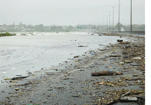
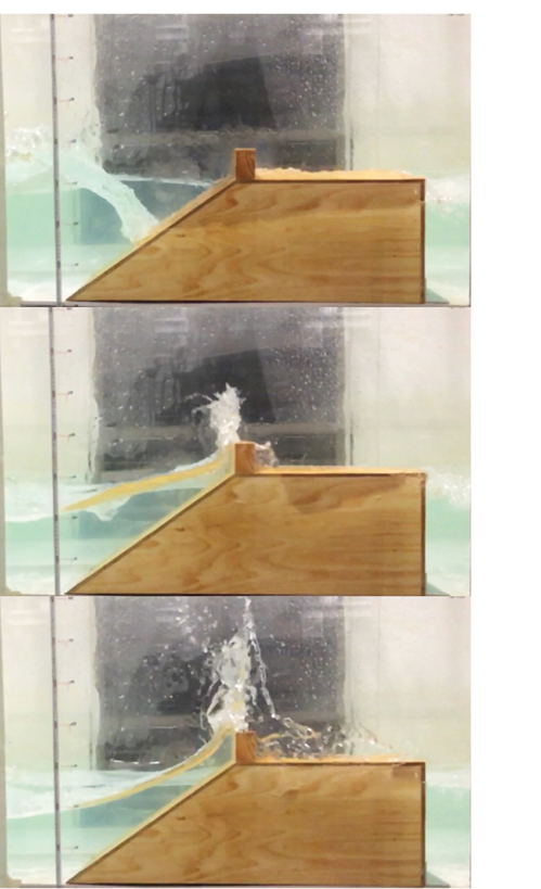
Figure: A 1:10 scale model of Tamaki Drive being tested under conditions replicating ex-tropical cyclone Ita, which occurred in 2014, with severe overtopping occurring, as was observed on site.
5. Conclusion
Sea-level rise and associated changes in coastal erosion and flooding hazards present a significant challenge for New Zealand that requires new, innovative and adaptive management and infrastructure approaches. Through the Coastal Theme within the ‘Resilience to Nature’s Challenges’ National Science Challenge, coastal researchers across New Zealand are working together and engaging with coastal managers, local government, industry, infrastructure operators, communities and tangata whenua to develop and implement new approaches to tackle the ongoing coastal adaptation challenge. In this article we have highlighted two ongoing projects within the Coastal Theme that will advance our understanding of past, present and future coastal change, and what this means for the provision and management of coastal infrastructure at risk.
If you are interested in finding out more about this research or the Resilience Challenge, or would like to receive research updates, please contact Emma Ryan by email (e.ryan@auckland.ac.nz) or visit our website (www.resiliencechallenge.nz).
Acknowledgements
We acknowledge funding from the Ministry of Business, Innovation and Employment for the Coastal and Built Environment Themes of the Resilience to Nature’s Challenges National Science Challenge. Thanks to Dr Paul Kench for his significant contributions to planning this work.
References
Bell, R.G., Paulik, R. and Wadhwa, S. 2015 National and Regional Exposure to Coastal Hazards and Sea-Level Rise: Areal Extent, Population and Assets, Prepared for Parliamentary Commissioner for the Environment; NIWA Client Report No: HAM2015-006; NIWA: Hamilton, New Zealand, June 2015; p. 134.
MfE, 2017. Coastal hazards and climate change: guidance for local government, Ministry for the Environment Publication.
Ministry for the Environment and Hawke’s Bay Regional Council partnership project (2020). Case study: Challenges with implementing the Clifton to Tangoio Coastal Hazards Strategy 2120. Wellington: Ministry for the Environment, 33 p. URL: https://www.mfe.govt.nz/publications/climate-change/challenges-implementing-clifton-tangoio-coastal-hazards-strategy-2120
Paulik, R., Stephens, S.A., Bell, R.G., Wadhwa, S. and Popovich, B. 2020 National-scale built-environment exposure to 100-year extreme sea levels and sea-level rise, Sustainability, 12(4): 1513; https://doi.org/10.3390/su12041513