
International Report – Landslide Risk Assessment and Mitigation (LARAM) course
Landslide Risk Assessment and Mitigation (LARAM) course – India 2020
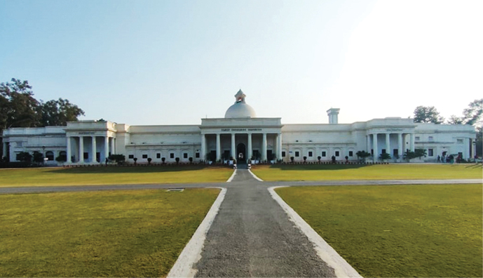
Above: IIT Roorkee was a perfect venue for the LARAM course due to its rich history in civil engineering. It was first established in 1847 to train engineers for the construction of the Ganges Canal, making it the second oldest technical institution in Asia. (Photo credit: Srujan Chalavadi)
I was lucky enough to be selected to participate in an international Landslide Risk Assessment and Mitigation (LARAM) course held at the Indian Institute of Technology (IIT), Roorkee in northern India between 17 and 22 February 2020. Roorkee is about 180 km north of New Delhi and is tucked in against the foothills of the Himalayas between the Ganges and Yamuna Rivers. The LARAM course was organized by the University of Salerno (Italy), the Norwegian University of Science and Technology (Trondheim, Norway), the Indian Institute of Technology Roorkee (India) and the Indian Geotechnical Society (Roorkee chapter). The course was open to a maximum of 21 international PhD students, 12 young PhD holders and/or professors, as well as 13 Indian professionals.
The LARAM School has been running annual courses since 2006, typically held in Europe, although three courses have been held in Chengdu, China. The February 2020 course was the first LARAM event to be held in India. Owing to its success, it is hoped this was just the first of many more to be held in India.
The aim of the LARAM School is teach state of art interdisciplinary practices for assessing, forecasting and mitigating landslide risk. The course, which involved a series of lectures, tutorials and a fieldtrip, covered the following themes:
- Landslide features, inventory
and monitoring, - Landslide risk theory,
- Geomechanics of landslides,
- Landslide zoning, and
- Landslide risk assessment
and management.
Above: LARAM India 2020 cohort.

Above: LARAM course involved five 8-hour days of lectures and a one-day fieldtrip to the foothills of the Himalayas.

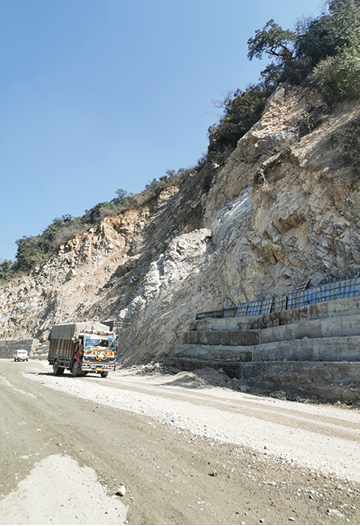
Above: Field trip in the foothills of the Himalayas demonstrated the challenges of landslides and infrastructure in India (as well as the questionable use of gabions and concrete walls).
The speakers were a fantastic array of renowned experts including Professors: Michel Jaboyedoff (Universtè de Lausanne, Switzerland), Michele Calvello (University of Salerno, Italy), Vikas Thakur (Norwegian University of Science and Technology, Trondheim, Norway), Sabatino Cuomo (University of Salerno, Italy), Sivakumar Babu (Indian Institute of Science, Bangalore, India) and the following cohort from the Indian Institute of Technology, Roorkee: Rathinam Anbalagan, Priti Maheshwari, Mahendra Singh and Narendra Samadhiya.
The course was intensive, covering advanced theories on a range of landslide-related topics which are highly relevant to our New Zealand setting. Personal highlights of the technical content of the course were:
- Introduction of LaRiMit (Landslide Risk Mitigation Toolbox) a free website (https://www.larimit.com/) developed by the Norwegian Geotechnical Institute. LaRiMit is an expert mitigation toolbox which uses a rating system to assess the suitability of a range of mitigation measures based on the user inputs (mode of analysis, type of movement, material type, depth and rate of movement, groundwater and surface water conditions).
- Multiple lectures on modelling landslide triggering and propagation which highlighted the importance of taking into consideration: a) partial saturation of soil matrix (soil suction) and its seasonal variations, b) antecedent moisture conditions: dry ground conditions promote higher runoff during short-duration high intensity rainfall events due to low permeability leading to a higher portion of debris flows rather than deeper seated landslides, c) the entrainment rate (basal erosion) of debris flows results in an amplification factor between the initial triggered volume and the final volume.
- Lectures and tutorials on risk analysis, risk mitigations and qualitative risk assessments. Multiple case studies were used to demonstrate the importance of developing local and regional hazard zonation maps that incorporate various methods hazard analysis based on triggering and site conditions. The outputs of the zonation maps and hazard assessments can be incorporated into risk analysis and integrated with early warning systems for the development of landslide risk management for sustainable and resilient development.
The ultimate highlight of the course were the personal networks established between all the attendees. The Indian cohort warmly welcomed the internationals who came from a number of countries including New Zealand, Austria and Brazil, and took pride in introducing us to their culture, food, incredible country and vast number of landslides. Fortunately due to the linguistic diversity of India, with 22 official languages (and hundreds of unofficial languages), the educational medium of all universities is English, so all conversations were inclusive.
The LARAM course was excellent and is highly recommended for
any PhD students or young PhD holders (within 5 years of submission).
Further information about future courses can be found on http://www.laram.unisa.it/.
I would like to thank the Mason Trust at the University of Canterbury for making my attendance at the LARAM India 2020 course possible.