
The invaluable use of drone imagery as a tool in landslide assessments
Keywords
Drone, landslide, cyclone, global, imagery
Abstract
The interpretation of aerial photographs has long been a valuable tool in terrain evaluation and identification of geomorphological features at a site. Publicly available aerial images for some parts of New Zealand date back to 1936 (such as those available on the Retrolens website), though rarely are they of sufficient quality to identify key features, and seldom taken immediately preceding and / or following a significant event. The recent availability, reliability and cost efficiency of using remote-controlled drones, and the high-resolution imagery that can be captured with them, has allowed access to instantaneous aerial images and led to drones becoming an invaluable tool when carrying out landslide assessments, particularly at unsafe and inaccessible sites. This paper presents several recent examples/case studies where drone technology was successfully used to overcome site constraints caused by access issues, health and safety considerations or simply due to the scale of the subject area.
1. Introduction
The heavy rainfall events of 27 January 2023, and Cyclone Gabrielle on 13/14 February 2023 brought devastation in the form of flooding and landslides across large swathes of the Auckland region, the impacts of which are still being felt today. The range in complexity and scale of the landslides is truly staggering, and exciting from a geological perspective but to be tempered with the humanitarian toll. A significant number of people relocated, homeowners literally living on the edge lying awake on a rainy night, and unfortunately fatalities.
Immediately following a severe weather event, an influx of requests for ‘emergency’ assessments across landslide affected properties and the potential for future (imminent) risk of those sites were made. Given the urgency of such assessments, the sites were inherently unstable and at risk of further movement, often making detailed site walkover assessments and geomorphological mapping exercises a hazardous task.
The recent availability, reliability and cost efficiency of using remote-controlled drones and the high-resolution imagery has fast become an invaluable tool used to capture important data which otherwise could not be recovered and at the same time removes direct risk of personal harm in an unsafe situation.
This paper discusses recent examples demonstrating where the effective use of remote-controlled drones has allowed for the detailed reconnaissance of landslide affected properties in otherwise inaccessible areas, or across areas of large expanse. We look at how their use awards the generation of more complete and robust conceptual ground models and how the information returned results in the overall reduction of time and cost to each project, reduces the risk of ‘unknowns’, otherwise remaining from a ‘ground-level’ assessment alone whilst also mitigating or in some cases entirely removing health and safety considerations associated with walking over a site.
2. Looking at the bigger picture
Initial site hazard assessments required the gathering of as much meaningful site data as possible within a limited timeframe in order to make a clear, informed assessment. Onground observations were often hampered by access constraints such as hazardous or contaminated terrain and densely vegetated ground. And with landslides often occurring across multiple properties, access permissions to enter neighbouring properties being problematic in cases, and often access to carry out cliff face assessments being tide dependent and/or sometimes not achievable without the use of rope or boat access; drone technology became an effective tool during recent events.
The use of drone imagery allowed a broader understanding of surface conditions and hazard assessment at a site and generally provided a perspective otherwise impossible to attain without significant additional expense (i.e. hiring a helicopter). The use of remote-controlled drones was also considered to be a cost-effective and a relatively quick method of surveying an area in relatively high detail.
Several examples outlining the benefit of using drone imagery as part of the initial site hazard assessment are presented below.
2.1 Example 1
Failures occurring on a large-scale (over hundreds to thousands of square meters) are generally difficult to observe from perspective at ground-level alone, especially when undulating ground, vegetation and structures prevent a direct line of sight across a broad area. It is also challenging to make detailed observations of ongoing ground movements across a wide-ranging area.
This example looks at the use of remote-controlled drones to capture aerial imagery across a rural residential subdivision, which resulted in the identification of significant ongoing movements following a series of severe rainfall events. The outcome of this assessment led to several properties either being deemed not safe to inhabit, or deemed at ‘imminent risk’ should further failures occur.
Such observations and ultimately the outcome of our assessment would likely have been very different had assessment been carried out from ground-level alone given the extent of the observed ground movements covered several neighbouring ‘lifestyle block’ properties.
The nature of the site, being characterised by a series of large-scale stepped plateaus, adjoining steep ridges / scarps and deeply incised gullies meant that the site was an ideal candidate for the use of drone reconnaissance.
Initial observations were made of relatively small-scale deformation / tension cracking (both vertical and horizontal displacement in the order of 20-30mm) through a portion of gravelled driveway (refer Figure 1). These initial observations were made on 20 January 2023, immediately preceding the events of 27 January 2023. Based on anecdotal evidence from the property owner, it was surmised that the cause of the cracking was likely resultant from intensive surface water runoff, rather than a more ‘global-scale’ movement of the wider hillside.

Figure 1: Annotated photograph showing small-scale deformation. Image taken 20 January 2023.
Based on an initial assessment taken from ground-level, no observations made indicated the likelihood of a larger-scale failure, with previous investigations across the area determining that ‘global’ slope instability was not of concern, with larger-scale features deemed ‘relic’ and not considered likely to reactivate.
As part of recommended mitigation measures, ongoing observations of the deformation / tension cracking were made by the property owner. Following the severe rainfall event of 27 January 2023, further deformation / ground movements were observed by the property owner.
At this stage (7 February 2023) a more detailed walkover assessment and critically a drone reconnaissance aerial survey was undertaken to identify the extent of the observed ground movements. Upon use of the drone, imagery was immediately and clearly fed back to the on-site engineers showing the extent of the failures to be far more extensive than originally believed, and with ground movements found not only to be endemic to the portion of hillside initially observed to have failed (Figure 2).

Figure 2: Annotated photographs showing comparison of ground-level imagery to drone aerial imagery. Image taken 7 February 2023.
Observations taken at ground-level were found to be limited given access and time constraints (due to impending poor weather conditions at the time of assessment).
As highlighted in Figures 3 and 4, the scale of the movements easily became apparent once perspective of the wider area was able to be captured.
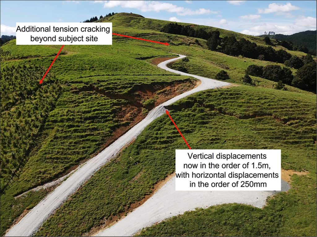
Figure 3: Annotated photograph showing aerial imagery of the subject area. Image taken 2 March 2023.
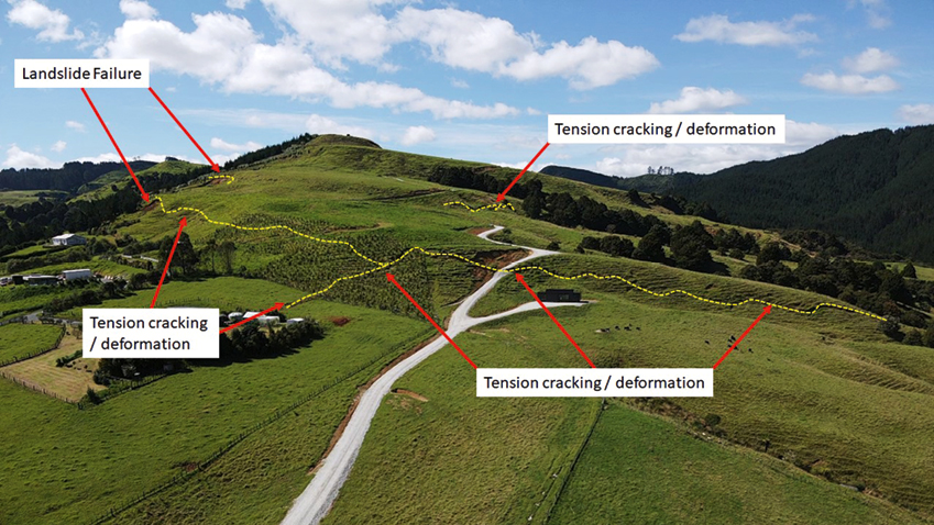
Figure 4: Annotated photograph showing aerial imagery of the wider area. Image taken 2nd March 2023.
The identification and presentation of the wider and more ‘global-scale’ features / failures (only achievable via drone imagery) allowed the neighbouring property owners to form a group and take a collaborative approach in discussing options / combining resources for potential remedial repair works which if otherwise undertaken on an individual basis would likely have been highly cost prohibitive.
2.2 Example 2
Figure 5 shows a drone photograph taken several days after ground movement was observed at this property following the significant rainfall events. Overland surface water flows from the road, and a high groundwater table were the likely triggering mechanisms for the failures on the moderately graded soil slopes.
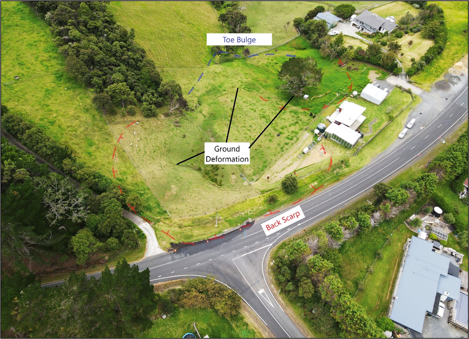
Figure 5: Annotated drone photograph showing large scale features of landslide.
Onsite observations identified ground cracking and back scarp features in relatively close proximity to the road and dwelling structures. Less obvious on the ground were the manifestations of movement within the slipped mass in the form of cracking and bulging, and the toe bulge feature which became apparent in the drone photographs. The identification of these features helped to build a conceptual ground model to determine immediate risk levels and allow for planning around future site investigations.
2.3 Example 3
This example highlights the use of drone imagery at a site at the top of a steep slope where on-ground observations of an adjacent landslip were limited by the presence of dense vegetation and the fall hazard posed by the steep slope edge (refer Figure 6). Access to the base of the slip was off limits at the time of the assessment due to emergency services working in
the area.

Figure 6: Photograph of the adjacent slip area from the site, observations limited by dense vegetation and steep terrain.
The drone imagery provided an unobstructed picture of the extents of the landslide, and the resolution of the images was clear enough to define different material types, and preferential surface water paths across the exposed face. The drone imagery allowed a more comprehensive assessment of the perceived imminent risk to the subject property than one based on ground observations alone. A drone image from the general area is shown in Figure 7.
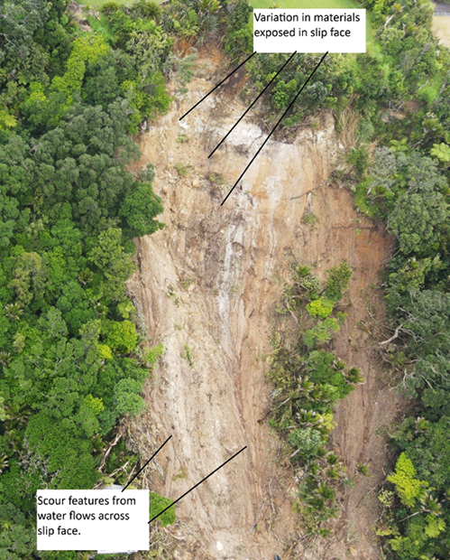
Figure 7: Drone photograph showing the large-scale nature of the landslide.
2.4 Example 4
Instability was observed within the Miocene aged flysch deposits exposed along Auckland’s eastern coastline at a number of locations following the heavy rainfall events. These materials can be highly susceptible to erosion and movement, particularly following storm events when concentrated water flows from the surface or stormwater outlets discharge directly over or onto the cliff face. This can lead to direct erosion of the materials, and / or saturation of the soil mantle which slides over the underlying rock mass. High wind loading on mature trees in these saturated conditions during or after the heavy rainfall events has also been observed to be a contributing factor to some of these failures where large volumes of soil and rock materials can be pulled out within the root systems when the tree falls.
There is an intrinsic safety risk associated with carrying out close-up cliff observations from the toe or the crest, which can be mitigated by drone photography. High resolution images of the materials within the face can be stitched together to allow a detailed visual rock mass assessment to be carried out, regardless of tide position.
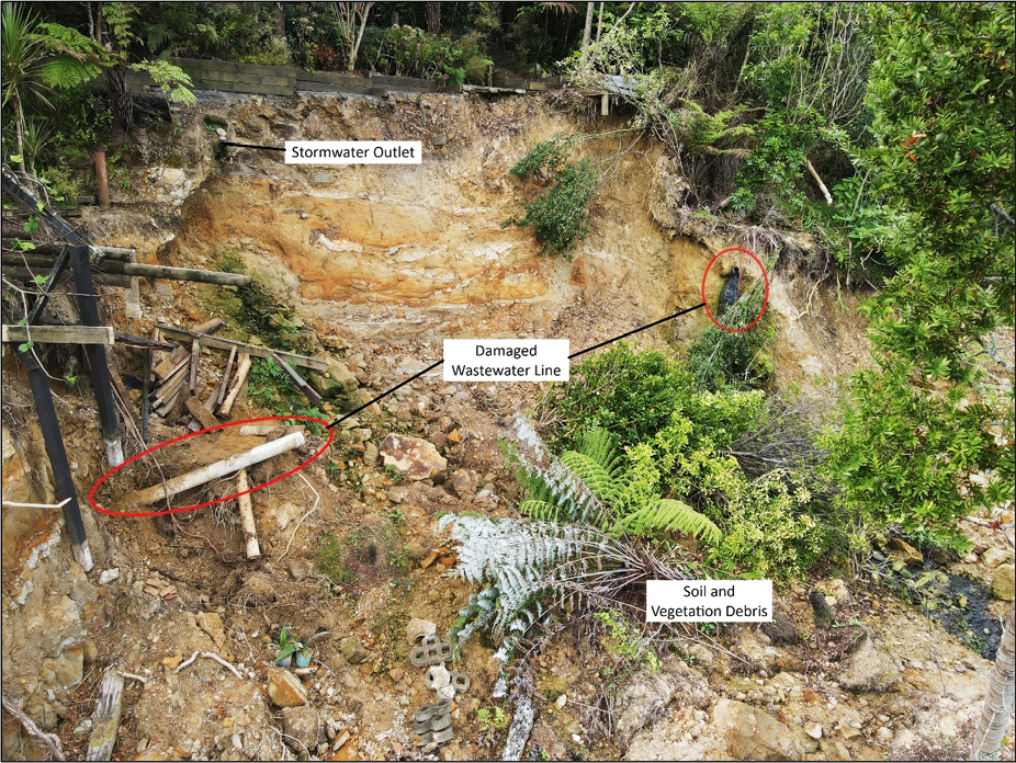
Figure 8 is a drone image from a coastal landslip which damaged a wastewater pipeline. The use of the drone meant that the assessment could be carried out safely, avoiding access issues to the foreshore and limiting exposure to contamination.
Figure 8: Drone photograph showing features.
2.5 Example 5
Similar to Example 4, and typical to the coastal cliff-top slopes of Auckland, heavy rainfall coupled by high winds resulted in the failure of the weathered residual soil mantle which overrides the underlying generally more stable rock mass.
Within this example, failure occurred across three adjoining properties, with varying degrees of severity. This portion of the Auckland coastline is well documented for these types of cliff-top slope failures, with large ‘historic’ drop out features observed within portions of the neighbouring cliff.
The owners of the three neighbouring properties made the choice to undertake a combined investigation and assessment due to limited access and to reduce the overall cost of the remedial works required.
A walkover of the properties from the cliff-top yielded little useful information of the stratigraphy of the cliff / extent of the failure (refer Figure 9), with a walkover along the shore line being equally limiting due to the height of the cliff, the angled nature of the scarp profile left by the failure and the presence of inundated debris at the toe of the cliff (refer Figure 10).

Figure 9: Photo from cliff-top. Limited observations able to be made.

Figure 10: Photo from cliff-toe. Limited observations able to be made due to presence of inundated debris.
Access otherwise requiring roped rappel (a timely, costly and hazardous undertaking) was easily and quickly achieved by use of the drone imagery.
From assessment of the drone imagery (Figure 11), it was evident to observe features within the rock and soil profiles such as the dip direction of the horizontally bedded rock and determination that the strata was continuous along cliff face for the width of the three adjoining properties.
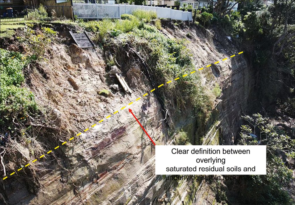
Figure 11: Drone imagery. Features unable to be viewed from cliff-top or cliff-toe clearly observable.
Aquisition of the aerial imagery enabled refinement of the project scope of works for investigation, and assisted in the early determination and suitability of the various potential remedail options (i.e soil nailing or rock anchoring vs. in-ground palisade support option).
3. Looking at the bigger-er picture
Beyond the use of drones for their capability to capture individual aerial photographs / videos, their application in tandem with third-party hardware and software can help further boost the powerful nature of this tool.
Some examples of other applications for the use of drones in the geotechnical realm include:
- Aerial LiDAR survey
- Photogrammetry
- 3D Mapping
- Volumetric calculations
- Augmented Reality (AR) generation
4. Limitations of use
As with most tools, drones do have their limitations and pilots must be aware of the applicable Civil Aviation and Privacy Restrictions related to flying. Drones generally shut down automatically if they fly too close to restricted areas (such as airports / military institutions), they don’t like going out in strong winds or rain and they don’t perform well after being submerged in the Waitemata Harbour. However, most of this can be mitigated with careful planning (and flying…) and the value returned from what is a relatively simple bit of gear is enormous.
5. Conclusions
In summary, the use of remote-controlled drones is quickly becoming an invaluable tool for engineers, providing a fast and cost-efficient method of data collection. By using drones, detailed information otherwise generally unattainable is now readily available, providing an additional layer of detail to any investigation, and assisting with the refinement / understanding of conceptual ground models. The ability for engineers to remotely operate drones from areas of relative safety also reduces the risk / need for engineers to put themselves in harm’s way, further ensuring the safety of those in our industry.
References
New Zealand Government (2023). Civil Aviation Authority NZ (Drones). Retrieved from https://www.aviation.govt.nz/drones/