
ABSTRACT
Geological and geomorphological mapping provide evidence for three complex fault zones in the Hamilton Basin, an area with no previously mapped surface fault traces. Rectangular drainage patterns, stream knickpoints, and linear ridge and drainage systems all point to structural control on the path of the Waikato River and its tributary gullies. Exposed fault traces indicate significant splintering of fault planes on encountering the soft sediments and tephras infilling the basin; hence fault zones are wide and characterised by multiple traces forming a complex ridge geomorphology. Steeply dipping normal faults are observed, with relative uplift to the north, indicating a north-south extensional environment. So far, no definitive evidence for movement more recent than 350 ka has been identified
1 INTRODUCTION
Recently faulted tephras were identified in an excavation during subdivision development in northern Hamilton City; analysis of a high-resolution digital elevation model (DEM) derived from LiDAR showed the trace of this fault running SW-NE across the Hamilton Basin. Prior to this discovery, no faults had been reported within surficial sediments in the Hamilton Basin. Hence, we embarked on a multi-method approach to better characterise the structure within the Hamilton Basin; particularly in terms of identifying structures developed in the Pleistocene and younger sediments that infill the basin. Our work involves geological and geomorphological mapping, re-assessment of publicly available geophysical data such as gravity, aeromagnetic, and seismic reflection surveys, and new shallow geophysical measurements. This paper presents aspects of our recent geological and geomorphic assessment of the structure of the basin.
2 BACKGROUND SETTING
The Hamilton Basin is a depression confined by the Hakarimata-Taupiri Ranges to the north, the Pakaroa Ranges and Maungakawa Hills to the east, and the Alexandra Volcanics and the Kawhia Syncline to the west. The surficial geology of the Hamilton Basin consists mainly of primary and reworked non-welded ignimbrites (Puketoka and Karapiro Formations) and tephras of the Pleistocene Walton Subgroup, overlain by a Late Pleistocene, low-angle alluvial fan deposit of reworked volcaniclastic sediments known as the Hinuera Formation (Edbrooke and Begg, 2005; McCraw 2011). Previous geological research of the Hamilton Basin concluded that the only faults affecting the basin were the non-active Waipa Fault inferred along the Junction Magnetic Anomaly (JMA) in the west, and the active Kerepehi Fault in the adjoining Hauraki Basin to the east. An additional E-W trending fault, the Taupiri Fault, was proposed by Kirk (1991) separating the Hakarimata-Taupiri Ranges from the Hamilton Basin. Information regarding movement on the Waipa Fault in this region is limited, with some evidence suggesting activity during the early Paleogene and possibly even into the Oligocene (Kear et al, 1978; King, 2000). Currently, seismic hazards within the Hamilton Basin, as defined by the National Seismic Hazard Model (Stirling et al., 2010), are considered to be relatively low due to the absence of known active faults.
3 METHODS
Tectonic geomorphology is key to understanding the structural history of soft-sediment filled basins. With the use of LiDAR data provided by the Waikato Regional Council the geomorphology of the basin is easily examined. The Waikato River in particular, is an important geomorphic tool as rivers act as linear structures that contain features such as terraces, floodplains, and channels that give insight into temporal changes associated with land movements (Schumm et al., 2000; Burbank & Anderson, 2012). Using a combination of LiDAR data, river geomorphology, and sidescan and multibeam images of the riverbed (Wood, 2006) we have examined tectonic geomorphic signatures within the Hamilton Basin.
Standard geological mapping techniques were employed to map riverbank geology, using foot access where feasible, and boat surveys from the Narrows Bridge (37° 50’ 30.7” S, 175° 20’ 54.2”) to the old Horotiu Bridge (37° 41’ 52.1” S, 175° 12’ 19.9” E) for all other sites. Sites exposed by development of the Hamilton Bypass section of the Waikato Expressway were also surveyed, notably a large cutting at Kay Road on the northern margin of Hamilton City (37°42’40” S, 175°15’25” E). In all cases, landform and outcrop photographs, sketches, stratigraphic logs, and measurements were taken, including dips and dip directions where relevant. Fault plane orientations were recorded using mobile application GeoID and location parameters were recorded using Garmin GPS. Samples were collected from areas where lithology could not readily be determined in the field and used for preparation of thin sections and Scanning Electron Microscope (SEM) samples.
4 RESULTS
4.1 River geomorphology and geology
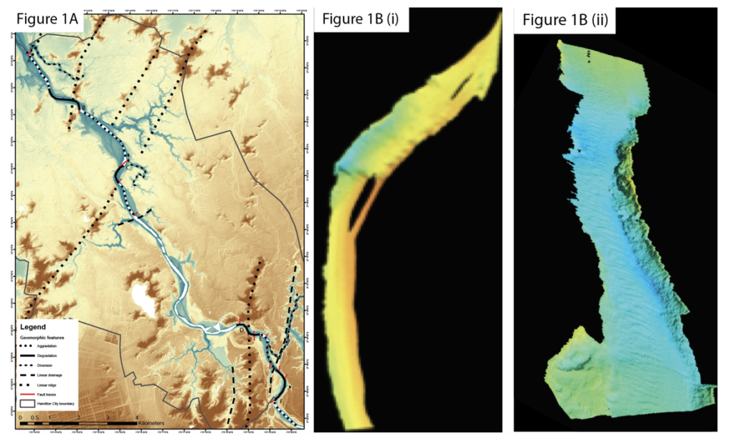
Figure 1A presents a DEM of the Hamilton City area derived from the LiDAR data. The Waikato River runs diagonally through the map from the lower right to upper left corners. It can be seen that the river undertakes a series of sharp bends, notably near Stubbs Road at the southern boundary of Hamilton (location B); in central Hamilton City near Lake Rotoroa (location E); at Day’s Park in northern Hamilton (location D); and a smaller one near Flagstaff in northern Hamilton (location F). This rectangular drainage system is accompanied by a pattern at three of these bend locations (locations B, D & F) where the upriver areas show aggradation and the downriver areas show degradation through entrenchment (Figure 1A). The aggradational zones are evidenced by broad embayments with well-developed terraces and a more sinuous channel, while the degradational zones are evidenced by a more incised channel with knickpoints, narrow terraces, and abandoned higher level channels. Multibeam data reveals an abrupt change in the riverbed nearby each of these sharp bends whereby the upriver side contains a resistant material and the downriver side more erodible material, resulting in the formation of knickpoints along the river’s profile (Figure 1B). These sharp bends are accompanied by linear ridges crossing the river, or tributary drainage systems (gullies) entering the river. The three sites (B, D & F) will be discussed in more detail in following sections.
Figure 1: (A) LiDAR DEM of the Hamilton Basin from the Narrows, Tamahere to Horotiu with marked tectonic geomorphic features found within the basin. Letters A-G indicate areas referred to in the text. (B) Sidescan and multibeam images of seafloor at (i) Stubbs Road (site B) and (ii) Day’s Park (site D).
A geological strip map along the Waikato River is shown in Figure 2. Ignimbrites are readily identified in outcrops near Stubbs Road (location B) and the Hamilton Gardens. Between these two sites, stratigraphic relationships between the ignimbrites and surrounding materials are indicative of faulted contacts, but only one directly identifiable fault exposure was recognised near Stubbs Road. Other materials of Walton Subgroup age are plotted as “Undifferentiated Pleistocene Sediments”; thin sections suggest that most of these are reworked pyroclastic materials, probably with very minimal local reworking from the weak ignimbrite deposits. Surprisingly little clearly identifiable Hinuera Formation sediments were exposed along the riverbanks in the area shown in Fig. 1B, though this is likely a function of vegetation and development patterns. As the Hinuera Formation forms shallow-angle (compared with other materials) slopes with unconsolidated sediment, vegetation growth on this material is extensive and hence obscures direct observation of the geology. Hinuera Formation is mapped in Hamilton City on the eastern bank of the river from Cobham Bridge to the Claudelands Bridge. It likely comprises considerably more of the riverbanks through the city portion of the map.
Figure 2: Geological map along the Waikato River, Hamilton City
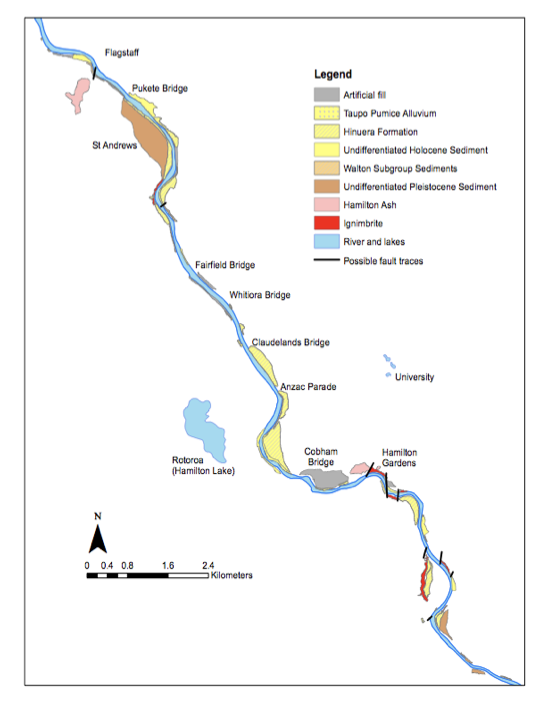
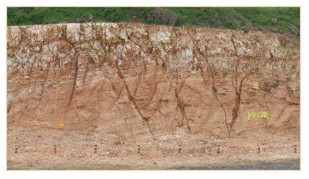
Figure 3: Exposed fault trace near Rototuna, Hamilton City.
4.2 Rototuna cutting
The site initially identified at Rototuna (location G, 37°43’24” S, 175°16’40” E) is a fault zone exposed in the wall of an excavation (Figure 3). The zone is approximately 4 m wide, comprising 4 main strands of the fault trace, with several smaller strands linking between them, and has a total vertical offset across the zone of approximately 0.5 m. Normal (extensional) movement occurs across this zone, with dips on the strands ranging from 51 – 84°. The 4 apparent main strands have an average dip direction of 089° (strike 356°), while the 2 measurable minor strands have a dip direction of 351° (strike 081°). Unfortunately, the top layers of the stratigraphy were removed during excavation, so limited stratigraphic information is available to date the movement of this fault. The white layers at the top of the cutting, which are clearly displaced by the fault movement, are tentatively identified as K12/K13 (Kauroa ash sequence) of approximately 1.23 million years ago. Soil infilling down the fault traces is identified as part of the Hamilton Ash sequence, being amongst the younger portion due to the strong brown colouration (the oldest Hamilton Ash units are pale coloured). This suggests that the fault movement is within the last 250 ka, but this is not definitive.
4.3 Kay Road exposure
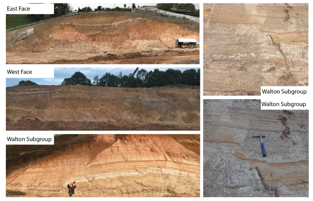
Recent cuttings created as part of the Hamilton Bypass portion of the Waikato Expressway development have exposed a complex fault zone in the hill section at Kay Road (location A) on the northern boundary of Hamilton City (37°42’40” S, 175°15’25” E). This site consists of a deep cutting through a hill (Figure 4), with the cutting running approximately normal to the strike of the ridgeline. Thus two exposures exist, one on each side of the cutting. Exposure of the cutting on the western face consists of an approximately 85 m long by 35 m high embankment, while the exposure on the eastern face is approximately 70 m long by 30 m high. Images of both the East and west faces are depicted in Figure 4 below.
These cuttings expose a complex fault zone with numerous steeply dipping normal faults, together with apparently lower angle linking strands. Relatively few fault planes are found within the the lower lying Walton Subgroup. An average observed dip of 57.3° was recorded for these faults, with an average dip direction of 191° (NNE) . Many more faults are observable within the overlying Kauroa Ash beds, suggesting splintering of the faults as they encountered the weaker tephric marterials. Displacement of a golden silt unit is immediately apparent, with a throw of 2.72 m observed. This throw was constant throughout the area, and occurred on both exposures of the unit within the field area. Faults within the Kauroa beds have an average dip of 73° and dip direction of 55°, trending across a NE-SW plane. The distinctive Rangitawa Tephra at the base of the Hamilton Ashes is undisturbed throughout the entirety of the Kay Road site, and no evidence for offset of this unit was found. It is, therefore, thought that faulting of these units is confined to a time sometime between deposition of the Walton Sub-group 1.8 Ma – 0.5 Ma, and deposition of the Rangitawa tephra 350 ka. These faults are thus inferred to be inactive.
Figure 4: Exposures at Kay Road. Eastern face, western face and Walton Subgroup exposures depicted above. Pictured right is faulting within the Walton Subgroup.
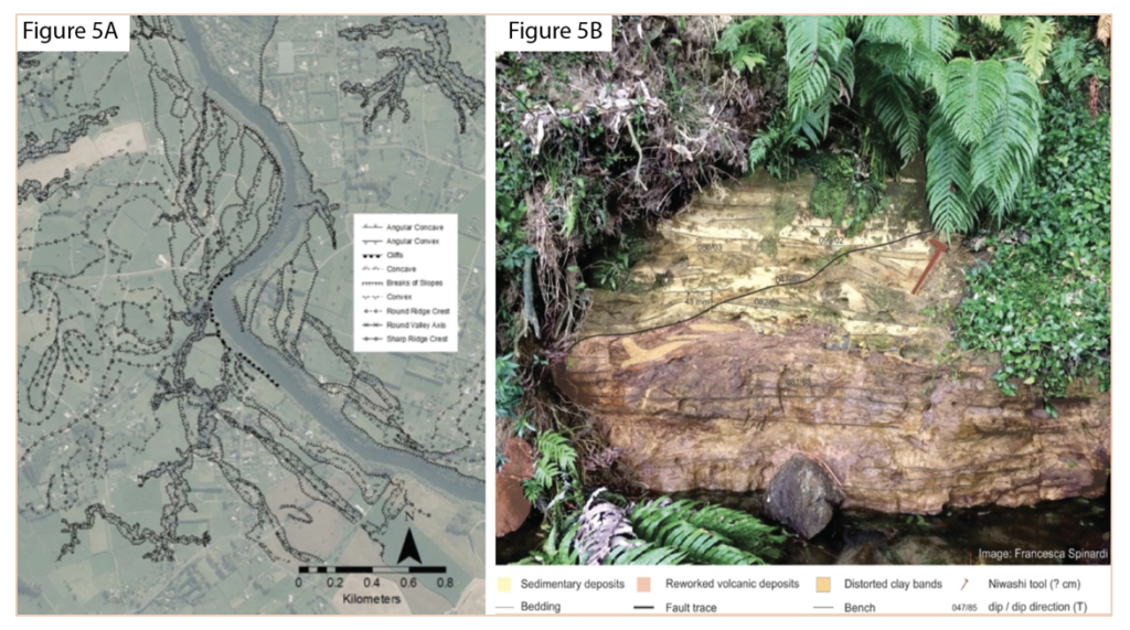
4.4 Stubbs Road
At Stubbs Road (37° 49’ 38” S 175° 19’ 34” E) the geomorphology consists of a north – south trending set of hills, which disappear into peat swamps to the north and south. The Waikato River appears to turn sharply to the northeast at Stubbs Rd, and more gently to the northwest closer to Hamilton City (Figure 5A). There are terraces flanking the river on the upstream side approaching the bend. While some continue around the bend, the pattern of terraces appears to be disrupted. Above the river on the western bank there is a deep channel (50-100 m wide) that initially follows the alignment of the upstream river channel, before turning towards the north. This has been interpreted as an abandoned river channel. A gully system containing a small stream enters the river at the sharp bend, and the system generally aligns with the river channel downstream of the bend (Figure 5A). The gullies in the Hamilton Basin have previously been considered to be formed in random locations by headward erosion within relatively homogenous materials (Schofield, 1965). However, the relationship between the gully system and the other features at Stubbs Rd suggests that at least some of the gully/stream systems within the Hamilton Basin are influenced by non-homogenous materials affected by faulting, resulting in stream locations that reflect underlying structures, either through exploiting weaker materials or by the effect of buried topography on groudwater flow concentration.
One measurable fault alignment was observable on the western bank of the river at 37°49’39.0”S, 175°19’35.2”E, as shown in Figure 5B. This fault offset shallow-dipping sedimentary beds at the base of the sequence, and was marked by ductile deformation of a pale yellow clay layer, together with ironstaining on the fault surface. Measured apparent vertical offset at this site was 43 mm and fault orientation was 85/047 (dip/dip direction, °T).
Figure 5: (A) Geomorphic map of Stubbs Road area (location A). (B) Annotated image of small exposed fault in riverbanks near Stubbs Road. Map courtesy Mike Cummins.
5 DISCUSSION
The Kay Road site provides an excellent window into the structure of fault zones within the Hamilton Basin. The zone shows complex deformation, with multiple, steeply-dipping, normal fault strands contributing to overall uplift of the hills in this area (uplift to north, downdrop to south). As the faults propagate into and through the weak materials in the basin, they appear to splinter: several relatively simple faults in the lower sedimentary units present as a complex pattern of intersecting fault traces in the upper tephra beds. Consequently, in identifying faults in this region it is important to recognise that we are unlikely to be seeing a single, well-defined fault trace, and total vertical offset is likely distributed over a number of different strands.
For fault zones where no exposure of displaced strata is available, we are forced to rely on more circumstantial geomorphic evidence. There are many process that contribute to the formation of river channels, but certain patterns are characteristics of tectonic regions, such as rectangular drainage patterns, deflection of the river channel, and changes in channel profile with accompanying knickpoints and associated areas of degradation/aggradation (Schumm et al., 2000; Burbank and Anderson, 2012). Within the Hamilton Basin the Waikato River displays a rectangular drainage pattern suggesting an influence of discontinuities on the river’s path, combined with morphological features indicative of episodic disruption of the drainage system. Rivers that are oriented perpendicular to the strike of a normal fault will experience changes in their channel types where areas of uplift cause the river to entrench itself, and areas of down-drop cause aggradation due to the river seeking to rebuild to its baseline (Schumm et al., 2000). Degradational areas contain knickpoints along river profiles and often display steep river slopes due to entrenchment. Areas of aggradation on the other hand contain shallower and broader channels that are either braided or more sinuous (Schumm et al., 2000). Such patterns are observed at the locations where fault zones were inferred from other evidence. The multibeam, sidescan and seismic survey data provide additional evidence, where knickpoints and discontinuities are present at each sharp bend (Figure 1). It is possible that during an earthquake the Waikato River became blocked by displacement of the footwall, causing the river to either be slowed or dammed and the creating regions of aggradation. Over time the river would have eroded a new path through the footwall creating a region of degradation. Alternatively the River has encountered these resistant zones as it entrenched following deposition of the Hinuera Formation.
Figure 6: Map of inferred fault zones recognised from surface exposures and geological mapping of the Waikato River. White outline is Hamilton City.

Based on the available data, we infer three main fault zones running southwest – northeast across the Hamilton Basin (Figure 6). We are using informal names for these and they are: Te Tatua o Wairere Fault Zone, extending from Stubbs Road northward through Hammond Park and the Hamilton Gardens and following the ridge through the University; Kukutaruhe Fault Zone, following the ridge from Te Awamutu through to Rototuna, and including the Rototuna and Kay Road exposures; and Horotiu Fault Zone, less well evidenced, near Horotiu. These are zones and display considerable splay in their traces, making for complex geomorphology. The faults that we have observed are dominantly steeply dipping normal faults, indicating formation in an extensional regime. Generally they are uplifted to the north.
6 CONCLUSION
The Hamilton Basin is considered an area of low seismic risk as no surface fault traces have previously been recognised in the basin. Our recent mapping has revealed several sites where complex fault traces can be identified, and geomorphic features which allow these traces to beextended across the basin. Hence, we now infer that the Hamilton Basin has a system of normal faulting indicating a north-south extensional regime, with relative uplift to the north. Assessment of the timing of the events is difficult due to limited exposure, but from the actual exposures discussed here, there is no definitive evidence for movement on these faults post-dating the ~350,000 year old Rangitawa Tephra at the base of the Hamilton Ashes. Further work is proposed to better define age and frequency of events.
REFERENCES
Burbank, D., & Anderson, R. (2012) Tectonic geomorphology (2nd ed.). Chichester, West Sussex; Hoboken, N.J.: J. Wiley & Sons.
Edbrooke, S. & Begg, J. (2005) Waikato (Institute of Geological & Nuclear Sciences Limited. Institute of Geological & Nuclear Sciences 1:250 000 geological map; 4). Lower Hutt, N.Z.: Institute of Geological & Nuclear Sciences.
Kear, D., Schofield, J., & Couper, R. (1978) Geology of the Ngaruawahia subdivision (New Zealand Geological Survey. Bulletin; 88). Wellington: New Zealand, Dept. of Scientific and Industrial Research.
King, P. (2000) Tectonic reconstructions of New Zealand: 40 Ma to the Present. New Zealand Journal of Geology and Geophysics 43(4), 611-638.
Kirk, P. A. (1991) Waipa Fault and the tectonic rotation of Hakarimata-Taupiri block. New Zealand Geological Survey Record 43: 81-84. Wellington, Department of Scientific and Industrial Research
McCraw, J. (2011) The wandering river: Landforms and geological history of the Hamilton Basin (Guidebook (Geoscience Society of New Zealand); no. 16). Lower, Hutt, N.Z.: Geoscience Society of New Zealand.
Schumm, S., Dumont, J., & Holbrook, J. (2000) Active tectonics and alluvial rivers. Cambridge, UK; New York, NY: Cambridge University Press.
Stirling, M.W., McVerry, G.H., Gerstenberger, M.C., Litchfield, N.J., Van Dissen, R.J.; Berryman, K.R., Barnes, P., Wallace, L.M., Villamor, P, Langridge, R.M., Lamarche, G., Nodder, S.; Reyners, M.E., Bradley, B., Rhoades, D.A., Smith, W.D., Nicol, A., Pettinga, J., Clark, K.J., Jacobs, K., 2012 National Seismic Hazard Model for New Zealand: 2010 Update. Bulletin of the Seismological Society of America, Issue 102(4): Pp. 1514-1542. Doi: 10.1785/0120110170
Wood, A. P. (2006) Morphodynamic Channel and Stability of the Waikato River: Karapiro to Nagruawahia Reach (Doctoral dissertation, University of Waikato).