
ABSTRACT
On 26th November 2017 a localised thunderstorm cell over the hills behind Roxburgh, Central Otago, produced up to an estimated 150mm of rain over a three-hour period. Four catchments experienced severe flooding and sediment movement (debris flows or debris floods), resulting in significant sediment deposition across the SH8 highway and within Roxburgh township.
The small steep catchments behind Roxburgh span up to 1000m of relief, with broad low-relief headwaters, transitioning to confined channels which descend steeply towards the Clutha River. Significant development exists on lower gradient alluvial fans at the range front. In the 2017 event, sediment was nearly exclusively sourced from within the active channel bed, or from channel bank erosion, and significant quantities of readily mobilised sediment remain. Vertical channel incision (>5m) and bank erosion has destabilised adjacent slopes along large reaches of the channels, causing on-going landsliding. Precedent from previous debris flow events in these catchments suggests the threshold for large-scale sediment movement will remain lowered for up to 5 years, until vegetation can restabilise channel beds.
The Otago Regional Council and other agencies have led efforts to manage the ongoing risk associated with debris flows in the Roxburgh area. This has included data collation (surveying, lidar, ortho-photography, rain gauge installation), expert geomorphic and engineering assessment, engagement with residents, and physical channel work. An assessment of engineering and aligned options aimed at further risk mitigation is currently underway. Physical mitigation options are constrained by channel steepness, excess sediment availability, and presence of existing urban development and critical infrastructure.
INTRODUCTION
The Roxburgh area, Central Otago, has a long history of debris flows and alluvial fan activity, typically associated with heavy rain during thunderstorms. Intense late afternoon rainfall on 26th November 2017 caused debris flows and debris floods, where sediment laden floodwaters escaped at least four creeks within and near Roxburgh township, causing extensive damage to infrastructure and property. In this contribution we review the history and characteristics of these catchments which make debris flows an ongoing risk. We describe the 2017 event, with a focus on the upper catchments which generated and controlled the transport of sediment, and describe post-event channel behaviour. Finally, we discuss the measures the Otago Regional Council (ORC) and other agencies are undertaking to manage the debris flow risk.
Physical Setting
The township of Roxburgh is sited on an elevated terrace of the west (right) bank of the Clutha River, at the foot of the Old Man Range, locally known as the Bengar Faces (Fig. 1). Catchments draining the schist cored range are typically 2–6km2 in area, and span up to 1000m of relief. Creeks have broad low-relief headwaters before steepening down the face of the range through confined gorges to emerge on alluvial fans overlying terraces on the right bank of the Clutha River. There are multiple generations of extensive deep-seated landslides throughout the mid and lower parts of the catchments, which appear highly coupled to creek incision.
The alluvial fans have been extensively developed for a combination of residential housing and intensive agricultural and horticultural uses. SH8 parallels the Clutha River and crosses a series of alluvial fans between Lake Roxburgh and Ettrick. The size of alluvial fans is controlled by the width of the terrace, with fans ranging from 0.1–1km in radius, with a surface fan gradient of approximately 0.1. Channels have been straightened and confined by banks to enable development across the alluvial fans.
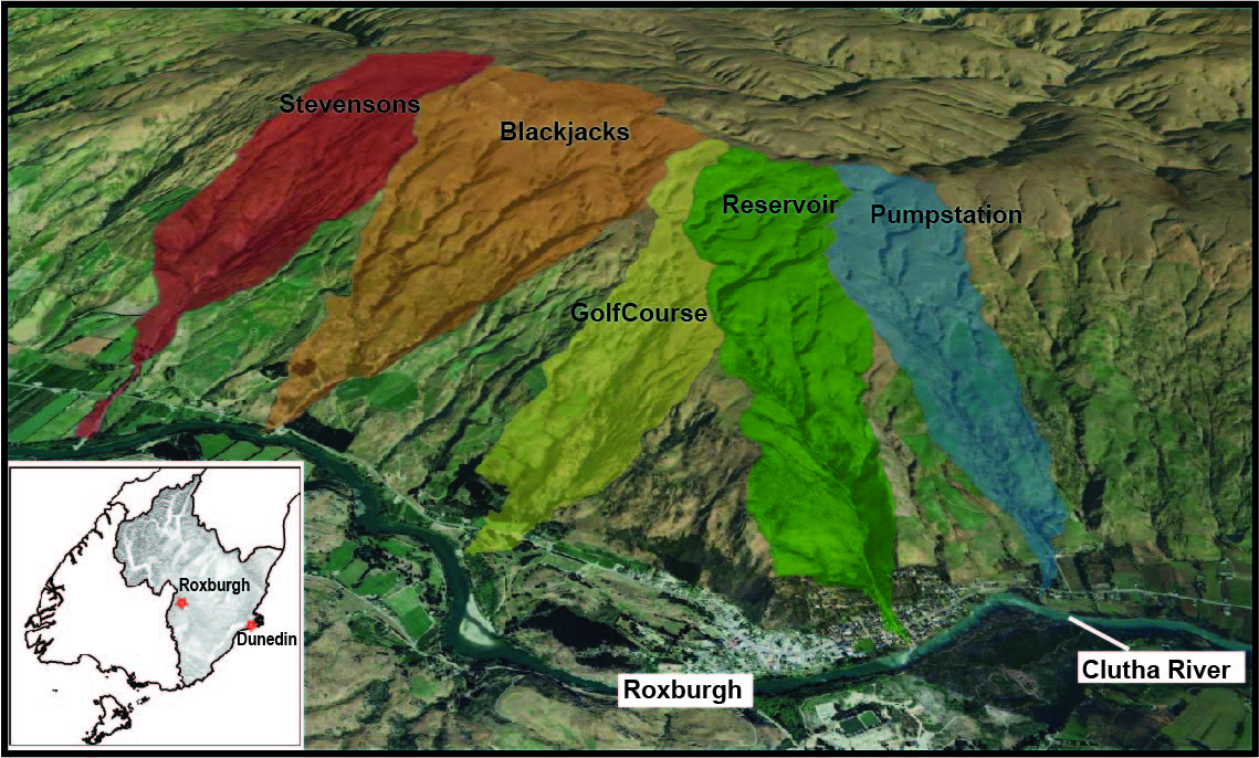
Figure 1: Oblique view of Roxburgh township (towards the west). The Clutha River and SH8 runs from right to left across base of image. Five catchments have been outlined. Inset shows location of Roxburgh in Otago.
History of debris flows
Debris flows have occurred historically in the Roxburgh area, with recorded events in 1938, 1978, 1993, 2015, and frequent smaller localised events. The 1978 event affected a wide area, causing debris flows and channel avulsion in multiple creeks. Reservoir Creek in northern Roxburgh aggraded and sent boulder debris through residential properties, prompting the construction of a 180m long concrete-lined chute, designed to rapidly convey flood waters and sediment down the alluvial fan surface to the Clutha River.
Given the history of events and prominent alluvial fan landforms, the Roxburgh area has a recognised debris flow hazard (Woods 2011) and active alluvial fan landforms have been identified (Barrell et al 2009).
November 2017 Debris Flow Event
On 26th November 2017 an intense downpour was centred on the hills behind Roxburgh. Up to an estimated 150mm of rain fell over a three-hour period (Dellow et al 2018), with 100mm falling in one hour during the peak of the event. Four Creeks near Roxburgh experienced high sediment loads and avulsed, depositing coarse sediment across their alluvial fans. Boulders up to 2m long were transported by the flows. SH8 was closed in 4 places due to deposition of debris across the road, and remained impassable for several days.

Figure 2: Photos from 27 November 2017. A: Mid-reaches of Blackjacks Creek showing channel scour. B: View up Reservoir Creek with scoured channel bed. C: Lower Reservoir Creek in northern Roxburgh showing debris lobe built into Clutha River. Excavator is clearing the concrete chute. SH8 runs along top of image.
At Reservoir Creek, the concrete chute filled completely with sediment and flows were routed through residential properties causing significant damage. A lobe of coarse sediment built out into the Clutha River, restricting channel capacity and forming a new series of rapids (Fig. 2C). Reconstructions of the event indicate that flows were initially efficiently conveyed down the concrete chute at an estimated rate of up to 70m3/s, but sediment accumulated in the comparatively low velocity water of the Clutha River. During the event sediment reaching the end of the flume was unable to be transported away, and built up a lobe obstructing flow from the chute. This initiated a feedback whereby the chute quickly backfilled with sediment. Capacity under the SH8 bridge crossing the upper chute was reduced, and the bridge and railings formed an obstruction causing avulsions across the lower fan. Fine sediment was carried up to 600m downslope along roads reaching the margins of the fan near central Roxburgh.
Channel and Catchment Behaviour
Channel response to flooding
Inspection of the catchments following the November 2017 event revealed the lower-gradient upper catchments were largely unaffected, but extensive channel scour and bank erosion (Fig. 2A-B, Fig. 3) occurred through the mid-reaches. Primary channels were scoured of vegetation and stripped of fine sediments for a length of up to 3.5km (Buech and McMorran, 2019a), with the depth of incision up to 5m.
As noted by Dellow et al (2018) unusually for a large debris flow event there was little evidence for hillslope landsliding. Debris flows commonly initiate as a landslide which mobilises and travels down the channel, but across multiple catchments, nearly all sediment was sourced from the channel bed or from small slips along channel margins associated with channel erosion.
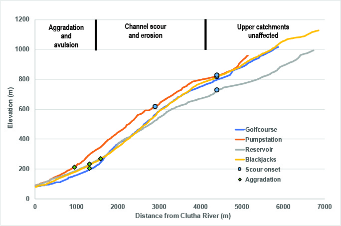
Figure 3: Long profiles of four catchments near Roxburgh. Markers indicate the onset of full channel scour, and the transition from channel incision to aggradation, respectively. Annotation across the top denotes channel reaches of different flow behaviour.
Analysis of the onset of channel scour across four catchments indicates a strong correlation between catchment area and channel slope (Fig. 4A). Using catchment area as a proxy for discharge, this suggests a strong stream-power control on the onset of channel scour. It is interpreted that once stream-power reached a critical threshold it was able to scour the channel bed and mobilise sediment into debris flows.
Common to all catchments, channels transitioned from incision and scour to aggradation and widening at a gradient of approximately 0.12–0.14. This transition from erosion to aggradation occurred up to 1km upstream of the alluvial fan topographic apex and it is independent of catchment area (Fig. 4B), suggesting channel slope controlled the change in flow behaviour. In the lower reaches, channel beds aggraded up to 3m, and associated lateral erosion resulted in extensive bank scour and undercutting.
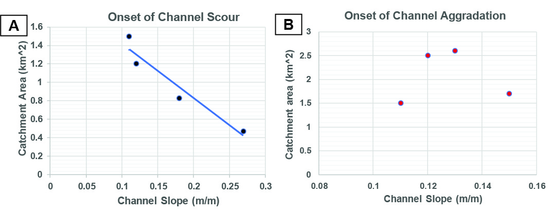
Figure 4: A) Relationship between catchment area and channel slope where full channel bed scour initiated, suggesting a critical stream-power threshold controlling the onset of scour. B) The transition from channel scour to aggradation appears independent of catchment area, but occurred where channel slope dropped below approximately 0.12.
On the developed alluvial fans, high flow volumes and the size of debris overwhelmed channel capacity sending flows across the fan surface. Constrictions such as culverts and bridges were unable to pass the 1-2m scale boulders, backed up and were common points of avulsion (Fig. 2C).
Subsequent catchment behaviour
Since the 2017 event, the threshold for further sediment movement has been lowered, with several less intensive rain events causing sediment movement and channel aggradation. This included ex-tropical cyclone Fehi in January 2018 (Dellow et al 2018), and further heavy rain in November 2018. The grain size of sediment mobilised in these subsequent events is typically smaller than the >meter-scale boulders moved in 2017, with decimetre-scale cobbles and finer sediment dominant. Following the 1978 event, further episodes of sediment movement were documented until approximately 1983, when it is likely vegetation re-colonised the disturbed channels, and increased the threshold for the initiation of sediment transport. A similar period of reduced threshold for sediment movement appears to be occurring now following 2017 event.
In the intervening years since the 2017 event, multiple deep-seated landslides have activated adjacent to deeply scoured or undercut channel reaches, most notably a 1.6ha bedrock landslide in the Golf Course Creek catchment which moved in November 2018 (Fig. 5). These landslides continue to supply sediment to the channels.
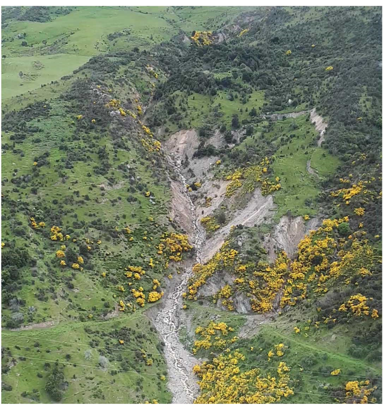
Figure 5: View up Golfcourse Creek showing a bedrock landslide which initiated in November 2018. This occurred adjacent to a section of channel that was incised up to 5m – see Figure 6.
Response and Ongoing Management
Restoration and Monitoring
Following the November 2017 flooding event ORC staff undertook an aerial inspection of the affected catchments and alluvial fans, and worked closely with Central Otago District Council and NZTA to remove debris and re-establish channel capacity. Additional extensive channel excavation and clearance was undertaken along Stephensons Creek south of Roxburgh (Fig. 1).
A bathymetric survey of the Clutha River in the vicinity of the sediment lobes was undertaken in late 2017 to assess the change in channel capacity due to the accumulation of sediment in the Clutha River. Hydraulic modelling (Webby et al 2018) indicated a slight increase in flood risk upstream of the Reservoir Creek at high flows, although this was offset by the probable erosion of sediment lobes during flood stages in the Clutha River.
A telemetered rain gauge has been installed in upper the Reservoir Creek catchment and is available on the ORC website to allow residents to monitor rainfall, and enable relations between rainfall intensity and sediment movement to be assessed. In 2018 the exposed channel sections were top dressed with coated seed, although due to subsequent floods this appears to have had limited success in encouraging re-vegetation and stabilising channels.
Two large landslides are being monitored to assess on-going patterns of movement, and a telemetered water level recorder has been installed on Reservoir Creek to monitor channel capacity during high flows.
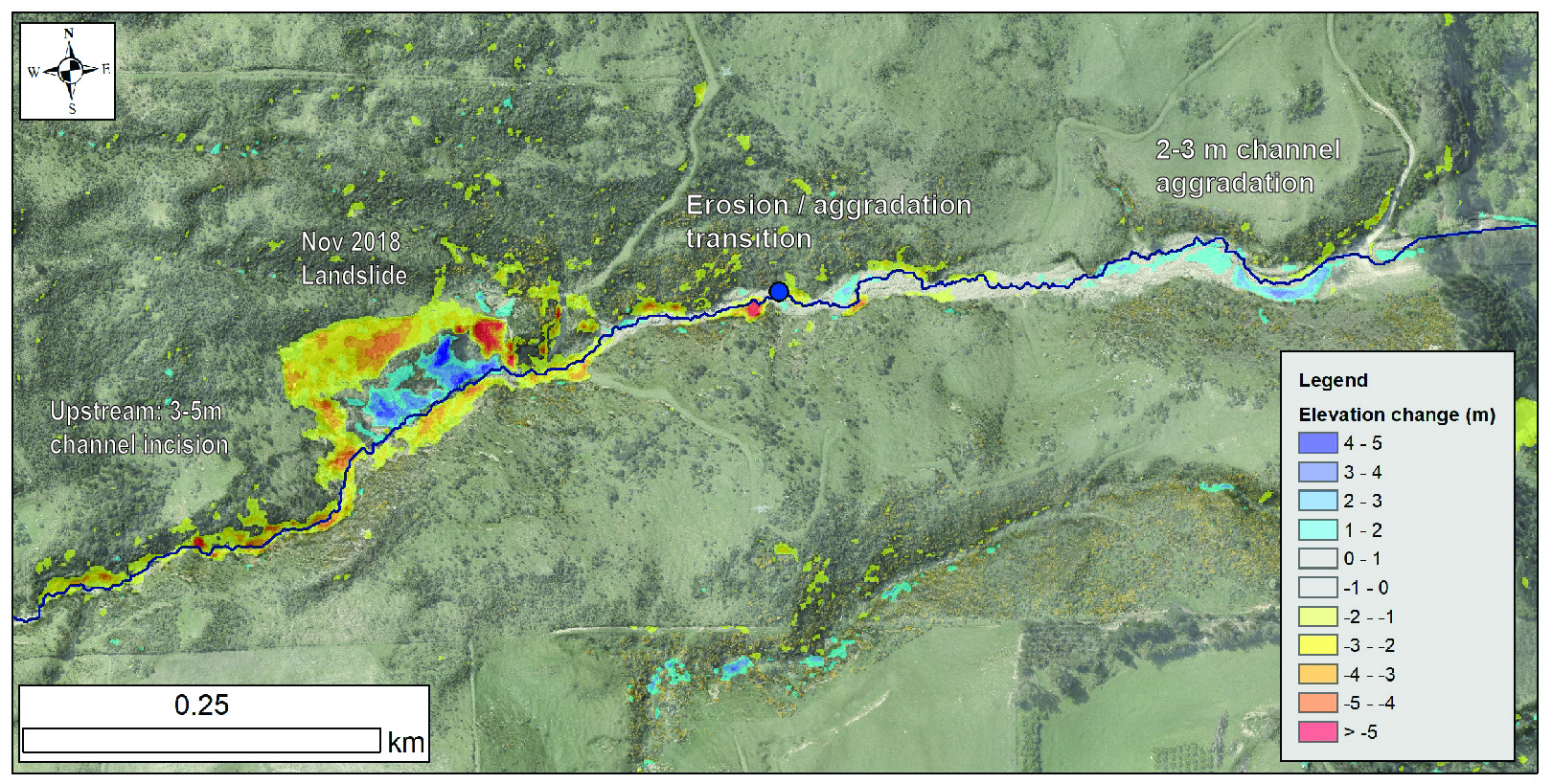
Figure 6: Map of lower reach of Golfcourse Creek showing elevation difference between 2006 and 2019 Lidar. The transition between erosion and scour to aggradation is evident in the elevation change of the channel bed. Channel runs left to right. The Nov 2018 landslide is shown in Figure 5.
Lidar and ortho-imagery of the affected area was acquired in 2019 to assist with ongoing management and monitoring of the catchments. Comparison with areas of pre-existing lidar across the lower portion of the catchments reveals the extent of channel change caused by the 2017 floods (Fig. 6).
Approximately 1000 m3 of sediment at the base of Reservoir Creek was removed in November 2019 to increase the sediment storage capacity between the base of the concrete chute and the Clutha River. This is intended to reduce the potential for the concrete chute to backfill during a future event. High flows in the Clutha River in December 2019 further eroded the sediment lobe.
Longer term mitigation options
Buech and McMorran (2019b) prepared a range of debris flow mitigation options for five creeks near Roxburgh. For creeks crossing rural areas, these focussed on protective bunding, increased culvert capacity under SH8, maintenance of channel capacity, and sediment retention structures.
Reservoir Creek, which runs through urban Roxburgh (Fig. 2C), has greater constraints on mitigation options due to proximity to residential properties, and the existing concrete chute and debris flow protection structures. Potential mitigation options for this creek include maintaining channel capacity, removing the sediment lobe at the Clutha River, armouring natural channel walls above the concrete chute, and extending the walls along the concrete chute. Sediment retention structures above the alluvial fan, such as nets, were also assessed, but have limited effectiveness due to access difficulties, and the high channel gradient which limits the potential retention volume.
Physical mitigation options, funding mechanisms, and other responses are currently being assessed by ORC and associated agencies.
Conclusion
Extreme rainfall in November 2017 caused debris flows and flooding across multiple catchments near Roxburgh. The steep catchments have a history of producing debris flows, and damaging property on the heavily developed alluvial fans at their base. The 2017 flows appear to have been triggered by high flows scouring the channel bed, rather than initiating as discrete landslides, as topographic control on the initiation of scour is common across multiple catchments. Landslides adjacent to deeply scoured channel reaches have activated since 2017, indicating a high degree of coupling between channel and hillslope processes. The ORC and other agencies have undertaken remedial work, expert assessment, and monitored the behaviour of the channels since 2017. This information is being used to work through a range of potential risk mitigation options.
References
Barrell, D.J.A., Cox, S.C., and Greene, D.B., 2009. Otago Alluvial Fans Project: Supplementary maps and information on fans in selected areas of Otago. GNS Consultancy Report 2009/052
Beuch, F. and McMorran, T. 2019a. Management and reduction of debris flow risk in Roxburgh, Otago – geomorphological assessment report. Report by Golder Associates prepared for Otago Regional Council.131p
Beuch, F. and McMorran, T. 2019b. Management and reduction of debris flow risk in Roxburgh, Otago – Engineering options report (conceptual design). Report by Golder Associates prepared for Otago Regional Council. 69p
Dellow, G.D., Jones, K., and Rosser, B.R. 2018. Hazard and risk assessment of the Roxburgh debris flows of 26th November 2017. Lower Hutt (NZ): GNS Science. 35 p. (GNS Science consultancy report; 2018/65).
Webby, G., Payan, J-L., and Mackey, B.H., 2018. Assessment of flood and bank erosion hazards in Clutha River at Roxburgh caused by debris flow run-out from intense rainstorm of 26 November 2017. IPENZ Rivers Group Newsletter, 22: 7-8
Woods, R. 2011. Otago Alluvial Fans: High Hazard Fan Investigation. Otago Regional Council. 79p