Simon Nathan (s.nathan@xtra.co.nz)
This article was previously published in the Geoscience Society of
New Zealand Journal of the Historical Studies Group 68, January 2021
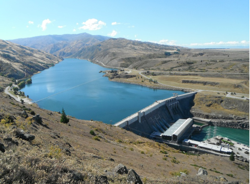
The Clyde Dam on the Clutha River (Fig. 1), which started generating power in 1993, was the last major hydro-electric scheme to be completed in New Zealand. It was a controversial project, with widespread opposition from local residents and environmentalists. Geological advice and assistance before and during construction was provided by members of the New Zealand Geological Survey (later DSIR Geology & Geophysics, then the Institute of Geological & Nuclear Sciences, now GNS Science). As well as the normal engineering geological issues that arise in a project of this size, there were delays because of the fractured nature of the rock at the dam site, the discovery of active faults, and the drainage and remediation of landslides in the reservoir area.
Figure 1. View of the Clyde dam, looking upstream along Lake Dunstan. Photo: Scott Barnard (AECOM, Christchurch)
During the 20-year life of the project, from about 1974-1993, there were major conceptual changes in a number of geoscience areas intertwined with political decisions. This article has been prepared as a summary of the geological issues that arose during investigation and construction of the Clyde Dam, based on written records and interviews. It is an interesting case study with lessons that I hope may be useful in considering future projects involving large-scale landscape modification.
Engineering and political background
After World War 2 there was a nationwide shortage of electricity – for example, residents of Otago had to endure regular power cuts until the Roxburgh dam began to generate power in 1956. The government started an urgent programme of hydro-electric development with a series of dams planned along the Waikato River in the North Island, and a similar programme in the South Island along the upper reaches of the Waitaki River. A skilled workforce was developed, and when one dam was completed they would move on to the next project. The growing demand for electricity overrode environmental concerns. But by the late 1960s there was a change in public opinion when the Manapouri power scheme was being developed to provide electricity for the Tiwai aluminium smelter near Bluff, which would have raised the level of Lake Manapouri. After widespread protests, led by the ‘Save Manapouri’ campaign, the Kirk Labour government agreed in 1973 that the lake level would not be changed.
As the hydro-electric schemes in the Waitaki catchment were completed, it was planned to build a series of dams along the Clutha River that would include a dam in the Cromwell gorge near Clyde. Preliminary investigations included ground surveys and a number of drillholes (McKellar 1967). A number of options were considered, and in 1975 the Labour government opted for scheme H, a low dam that would minimise the size of the reservoir, with a second low dam further upstream.. After an election later that year, the incoming Muldoon National government decided to proceed with scheme F, a much higher dam that would generate more power but flood established orchards, the railway and road as well as parts of Cromwell. Protests were ignored, and the high dam became part of the government’s ‘Think Big’ policy, with the aim of using surplus power for a second aluminium smelter.
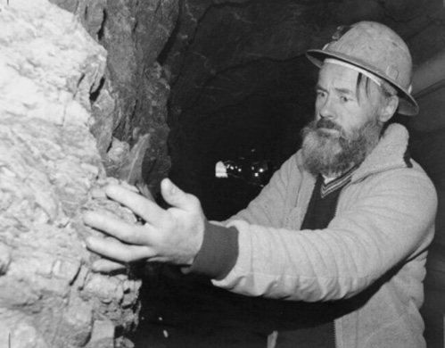
Design and construction of the Clyde Dam was the responsibility of the Ministry of Works and Development (MWD, later Works Consultancy Services Ltd). As had happened in the past, members of New Zealand Geological Survey provided consultancy advice on geological matters and were actively involved in on-site investigations under the supervision of Chief Engineering Geologist Les Oborn, then by Graham Hancox after Les retired. Royden Thomson (Fig 2), an experienced engineering geologist who had previously worked on the Manapouri project was appointed site geologist, and moved to Cromwell in 1974. Initially he was told that the project would last two or three years, but it was almost 20 years until he could hand over the dam completion report (Thomson 1993). At different times he was assisted by other site geologists including Jim McLean, Mark Foley, Graham Salt and many visiting geoscientists.
Figure 2. Site geologist Royden Thomsen examining rock exposed in a drainage tunnel at the No 5 Creek slide in August 1989. Dominion Post collection, Alexander Turnbull Library
Damsite investigations
The geology of central Otago was reasonably well known in the early 1970s as it had been covered by regional 1:250,000 geological mapping only a decade earlier. Ian Turnbull had started more detailed mapping of the Cromwell area which covered the area around the damsite, and provided copies of his field maps as investigations. got underway. The dam site (DG3) was in hard Otago schist at the lower end of the Cromwell gorge, and it was assumed that construction would be straightforward. Some landslides had been identified in the reservoir area (including the Clyde landslide at the dam site), but were not anticipated to cause major problems.
The schist at the dam site was foliated (or layered), and had undergone several phases of deformation. As a consequence there were common shear zones, both parallel to and oblique to foliation, some of which contained layers of low-strength clayey gouge. The foliation itself was almost horizontal or gently dipping. Angled drilling showed the presence a narrow zone of crushed rock at right angles to axis of the dam which subsequently became known as the River Channel Fault. Other smaller faults and joints were mapped by the site geologists as excavation proceeded. Although the rock appeared hard in handspecimen and drill core, once excavated it was more broken and permeable than anticipated.
As a consequence of the defects in the rock, many excavations on varying scales were required in the dam foundations, especially in areas where adversely oriented foliation shears caused concern that part of the dam might slide. Crushed material was excavated out of the River Channel Fault, to be replaced by concrete. Widespread cement grouting was needed to fill voids and avoid leakage around the dam.
In 1982 a contract for construction of the dam was awarded to the Zublin-Williamson consortium. The original contract provided for excavation of 14,000 cubic metres of rock to provide a solid foundation. But eventually the contractors had to dig out almost twenty times that amount of weak rock. The specified concrete pour was 650,000 cubic metres, but the amount poured was 870,000 cubic metres, a third more than specified (Ministerial Review Committee 1990, p 41). One of the final events of the dam construction phase was a long and complicated arbitration case where the contractor claimed for additional costs. Royden Thomson provided expert evidence and underwent lengthy cross examination.
Changing ideas about faulting
From earlier geological mapping, it was realised that the Dunstan Fault separated Otago schist from younger sediments in the Manuherikia depression to the north of the damsite, but the faulting was believed to be ancient. In the early 1960s it was generally believed in the geological community that central Otago was seismically inactive – the 1:250,000 maps of the 1960s did not show a single active fault between the Alpine Fault in the west and the Akatore Fault near Dunedin (which was regarded as an oddity).
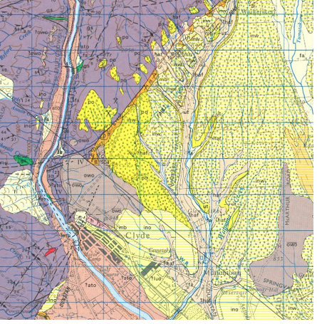
Work started on the DG3 site in 1976. From study of aerial photographs Royden Thomson was intrigued by a faint linear feature on a late Quaternary surface north of the dam site close to the Dunstan Fault. He and Ian Turnbull were able to get a trench excavated across the feature which revealed that sediments beneath the surface had been offset by fault movement (Fig 3). It was the first indication of young fault activity in central Otago, with the implication that the region might not be as seismically inactive as previously thought. This was the start of intensive seismotectonic studies of the area around the dam site and further afield in the upper Clutha catchment. The evidence for young faulting was not easy to detect, but was assisted by extensive low-level aerial photography by Lloyd Homer. Royden Thomson, Ian Turnbull and a group of earthquake geologists investigated possible faults, with trenching of selected sites, and this work was integrated with geological mapping. This showed that there were several active traces along the Dunstan Fault (Fig 4), although all were several kilometres north of the dam site. Despite the huge increase in knowledge of active faulting in the region over the next five years, this was not satisfactorily communicated to the dam design engineers.
Figure 3. Log of first trench excavated across a suspected fault scarp at Waikerikeri valley in August 1977. Provided by Royden Thomson.
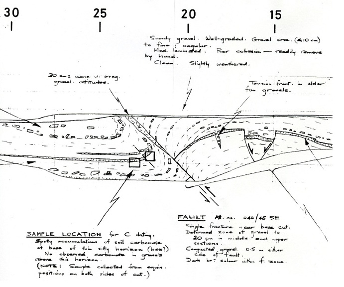
Figure 4. Section of the 1:63,360 geological map covering the area around the Clyde Dam (Turnbull 1987). This map shows the active fault traces identified during investigations in orange-brown.
In early 1982 the site was visited by Don Deere, an US engineering geologist with experience in dam construction who was engaged by MWD to advise on grouting the dam foundations. As well as reviewing the excavated dam site, he raised concerns about the possibility of a future earthquake on the Dunstan Fault that might activate the River Channel Fault. MWD requested an immediate synthesis of the work on active faulting and seismotectonic hazard so that they could evaluate the potential effects on the proposed dam.
The revelation that seismic activity was a possibility coincided with a political crisis. There was a public hearing into the final stages of the water-right hearing for the high dam, and the government was forced to pass amending legislation to allow the project to proceed. There was intense public interest in the issue of future seismic activity, and the Director of the Geological Survey, Pat Suggate, decided that the report sent to MWD must also be publicly released. Realising that he would have to defend the conclusions, he took an active role in the final preparation of the report (Officers of the NZ Geological Survey, 1983). One of the main conclusions was that the Maximum Credible Earthquake likely on the Dunstan Fault was between 7.0 and 7.5, with a return period of 12,500 years. The probability of this occurring in the next 100 years was estimated to be low to very low, but if it did happen there might be some sympathetic movement on the River Channel Fault.
Because of widespread interest and concern within the geoscience community, the report was reviewed by a subcommittee set up by the Geological Society of New Zealand. (R.J. Norris, C.A. Landis and D.H. Bell). While generally supporting the NZGS report, they felt that the estimated return period of surface displacement was too low. Their report and a response from NZGS were published in GSNZ Newsletter 63 (February 1984), pp 14-18.
As a consequence of the information on the seismotectonic hazard, the dam design was modified, including a slip joint to incorporate 1-2 metres of movement on the River Channel Fault. The redesign led to a decrease in generating capacity of the dam from 612 to 464 megawatts (Hatton, Foster & Thomson 1991).
Following the general election in 1984 a Labour government was elected. Although they had opposed the concept of the high dam, construction was too advanced by that time to abandon construction without huge financial penalty, so work continued.
In 1987, as part of major government reorganisation, the ownership of the electricity generation capability, previously controlled by the NZ Electricity Department, was transferred to the Electricity Corporation of New Zealand (ECNZ), a state-owned enterprise. This was to have a major impact on the final stages of the Clyde Dam project. By late 1988 the construction of the dam was nearly complete, and plans were underway to start filling the reservoir.
Landslide problems
The presence of landslides in the Cromwell gorge had long been known and shown on geological maps (Turnbull 1987), but were not believed to pose major problems as they were thought to be ancient and inactive (Fig 5). Objectors to the Clyde Dam, however, pointed to the Vajont Dam in Italy where a landslide in the reservoir in 1963 caused a seiche that overtopped the dam, causing almost 2000 deaths downstream.
Figure 5. Map showing the main landslide areas surrounding the Cromwell gorge (now Lake Dunstan), from Macfarlane and Silvester (2019).
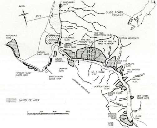
Until the early 1980s it was believed that only the Clyde, Cromwell and Cairnmuir slides were of concern, and would need remedial action. All the known landslides were monitored during the construction phase, and it was discovered that some ’dormant’ slides in the Cromwell gorge were slowly moving downhill. Exploratory drilling for the new highway led to the discovery of a complex, high-pressure groundwater system near the base of the No 5 Creek slide, and this led on to an extensive drilling programme on other landslides. By 1989, when filling of the reservoir was due to start, an external review recommended further investigation and remediation of the landslides.
A strategy was developed for a fast-track stabilisation program, based primarily on the use of tunnels for both investigation and drainage. All known landslides were re-mapped in detail, combined with drilling and tunnelling (Gillon & Hancox 1981). Up to 40 geologists worked on the landslides over a two-year period (Fig 6) – it was the largest engineering geological investigation ever undertaken in New Zealand. Gravity drainage was the main method of remediation combined with grouting, buttressing, some pumped drainage and continuous monitoring.
Figure 6. Group of engineering geologists working on landslides in the Cromwell Gorge during the summer of 1991-92. [This probably represents less than half the geologists who worked on the Clyde dam project]. Photographer: Gary Randall, MWD.
Back Row: Richard Justice, Richard DeLuca, David Stewart, Jeff Bryant, Royden Thomson, David Barrell, Graeme Halliday, Peter Brooks, Bruce Riddolls, Dean Fergusson, Virginia Cunningham.
Front: Tim Coote, Glen Coates, Neil Crampton, Guy Grocott, Dick Beetham, Don Macfarlane, Gary Smith, Peter Wood, Mark McKenzie, Charlie Watts.
[Others who worked on the project include Paul Horrey, Linda Price, Kelvin Moody, Mark Stirling, Gabrielle Bell, Bill Leask, Peter Manning, Stuart Read, Elizabeth Sowerbutts, Mary-Clare Delahunty, Mark Foley, Graham Salt, Angela Smith, David Ker, Graham Hancox, Ian Brown – with apologies to anyone omitted from the list].

The filling of Lake Dunstan behind the dam commenced in 1992 when the four diversion sluices were closed. The reservoir reached its maximum operating level in September 1993 after a series of intermediate steps to check the continuing stability of the landslides.
Monitoring and visual observations over the last 27 years indicate that the landslides are behaving as predicted – they have been classified as either dormant (<2 mm/year) or creeping (2-5 mm/yr) (Macfarlane and Silvester (2019).
Geological lessons from the Clyde dam
Construction of the Clyde Dam took much longer than anticipated, with a final cost more than 45% above the original estimate. It was a controversial project from the start, with continuous public scrutiny and criticism through the whole construction period. I had a personal taste of this in 1989 when, as Acting Director of the Geological Survey, I had to take part in a press conference explaining that filling of the dam would be delayed for several years due to the need to investigate and remediate landslides in the reservoir area. I was worried that geologists would be blamed, but on the day the reporters were only interested in questioning ECNZ about financial management of the project.
In 1990 the government called for review of the whole Clyde Dam project, and particularly for the reasons for the cost blowout and delays, and I refer readers to this for a frank appraisal of the decision making process (Ministerial Review 1990). But to conclude this short review, I would comment on several geological/geotechnical issues.
One of the major conclusions of the review was that there was a lack of a proper investigation process prior to the start of construction. The DG3 site was selected essentially for political reasons, and had less investigation than other sites preferred by engineers. Only 2.8% of the expenditure by DSIR geoscientific team occurred prior to the final commitment of the project. While the need for a higher level of investigation is unarguable, it is important to realise that some of the issues that arose could not have been reasonably foreseen. For example, while it is tempting to suggest that more investigation would have revealed the presence of active fault traces along the Dunstan Fault and elsewhere, it has to be remembered that there was a widespread belief within the geological community that there were no active faults in central Otago. The first fault traces were not identified by the specialists in the Geological Survey who studied active faults nor by university colleagues, but by site geologist Royden Thomson scanning aerial photographs outside the immediate damsite area. Subsequent work identified more active fault traces in different parts of central Otago.
The discovery of active faults in 1976 led to concentrated investigations over the next five years that included trenching and C14 dating that allowed the history of past fault movements to be worked out, developing a methodology for fault investigation that is still being used today. Strangely, however, this work appears to have had virtually no impact on the design of the dam because of lack of communication between geologists and engineers until visiting US geologist Don Deere raised concerns in 1982.
The Clyde dam site was excavated in the foliated schist that is widespread in Otago. It was assumed that excavation would be straightforward, but in fact there turned out to be widespread shear zones both parallel and oblique to foliation as well as faults and open joints. The combination of these defects in the rock mass meant that the amount of excavation and concrete remediation was much larger than anticipated. While this was difficult to anticipate in advance, it is a lesson for future excavations in schist.
Initially it was assumed that the landslides upstream from the dam site were inactive, but continued monitoring during the life of the project showed that some were creeping downhill very slowly, and investigations along the road line showed locally elevated water pressures. There was a debate about the amount of drainage and remediation needed to stabilise the landslides, but ECNZ elected to take a conservative approach, with continuing monitoring since the dam was filled in 1993.
The above paragraphs are illustrations of the sort of geological problems that arise in a major civil engineering project of this size and complexity. Although more preliminary investigation may have allowed some of them to be minimised, it is realistic to expect that there will always be unanticipated problems in dealing with complex geology.
The concentrated work on landslides involved large groups of engineering geologists, all of whom gained experience on the project. As they dispersed around New Zealand, many have become leaders in the geotechnical profession. There were several important advances as part of the landslide work, including the development of GIS technology for geotechnical work, the project-wide use of 3D modelling, and the development of a computer-based monitoring system, still used 30 years later for all major New Zealand dams.
Bearing in mind the controversy over the construction of the Clyde Dam, it is interesting to realise that it is now accepted as part of the natural environment in central Otago. I recently saw a sign advertising “Lake Dunstan – the jewel of the Clutha”, and power companies are proud to advertise that their electricity is 100% renewable.
References
- Gillon MD, Hancox GT 1992. Cromwell landslides – a general overview. Proceedings Sixth International Symposium on landslides. Ballema, Rotterdam: 83-102.
- Hatton JW, Foster PF, Thomson R 1991. The influence of foundation conditions on the design of the Clyde Dam. Commission International Des Grands Barrages, XVI Congress, Vienna, 157-77.
- Macfarlane D, Silvester P 2019. Performance and management of Cromwell Gorge landslides, Clyde Dam reservoir. ANCOLD 2019 Conference, 9-12 October, Auckland, 1-9.
- McKellar IC 1967. Clutha River Power Development. Geological report on Clyde damsites DG3/1 and DG3/2. NZ Geological Survey Engineering Geological Report 196.
- Ministerial review committee report to Cabinet (1990). Clyde Dam Project decision making.
- Officers of the New Zealand Geological Survey 1983. Seismotectonic evaluation of the Clyde dam site (2 volumes). NZ Geological Survey Engineering Geological report EG375.
- Thomson R 1993. Clyde Dam engineering geological completion report (2 volumes). Institute of Geological & Nuclear Sciences contract report C-1992/18.
- Turnbull IM 1987. Sheet S133 – Cromwell. Geological Map of New Zealand 1:63360, map (1 sheet) + notes. Wellington, Department of Scientific & Industrial Research.
Acknowledgements
In preparing this article, I have consulted many colleagues who worked on different aspects of the Clyde Dam project. In particular I am pleased to thank Kelvin Berryman, Ian Brown, Graeme Hancox, Don Macfarlane, Royden Thomson and Ian Turnbull for reading draft versions and providing useful comment. I am also very grateful to Kristin Garbett (GNS Science) for her help locating reports and other documents.
Royden Thomson worked as site geologist based at Cromwell through the 20-year life of the project. Many of those interviewed commented on Royden’s thorough work, wide knowledge and wise counsel – one person described him as “a quiet voice of sanity when problems arose”. This paper is dedicated to him.