
Key words: Cyclone Gabrielle, KiwiRail, geotechnical, civil
1. Introduction
As with a large portion of the North Island’s transport infrastructure, KiwiRail’s network was heavily impacted by Cyclone Gabrielle that occurred in February 2023. The Palmerston North to Gisborne Line (PNGL) was the most severely affected, due to a large portion of the line being located within the badly impacted Hawke’s Bay region.
The PNGL operational section is currently 295km long, starting in Palmerston North. It traverses through the Manawatu Gorge to Woodville where it links with the northern section of the Wairarapa Line. From Woodville it runs the length of the Hawke’s Bay region (with a key connection into the Port of Napier) before terminating at Wairoa. The PNGL has an extensive history of significant storm damage, with the Wairoa to Gisborne section being mothballed in March 2012 following a large storm. The Napier to Wairoa section was subsequently mothballed in December 2012. The Napier to Wairoa section reopened in 2019, thanks to investment through the Government’s Provincial Growth Fund (PGF), and construction of a road/rail log yard in Wairoa. Large scale remedial works and track upgrades were required for the reopening.
The PNGL currently provides an important link between the Port of Napier and Palmerston North, while also servicing the forestry industry in the Wairoa district and the Gisborne/Tairāwhiti region.
2. Palmerston North to Hastings
Due to the initial widespread road closures, the focus was getting the Hastings south section operational in order to reconnect Hawkes Bay to the rest of the country. Similar to the response following the Kaikoura earthquake, a mantra of “ugly, fast opening” (UFO) was adopted, prioritising operational requirements before considering progressive longer term reinstatement.
The initial KiwiRail response was coordinated by the Regional and Engineering Services teams. The majority of the Palmerston North to Hastings section was assessed by a number of field teams comprising civil and geotechnical engineers, as well as UAV surveyors. The main objective of the assessments was to assess cyclone damage in a standardized manner, identify high risk and logistically challenging sites requiring urgent remediation, and providing preliminary remedial recommendations.
Bridge 176 (Figure 1) in Waipawa was one of the first encountered and more severely impacted sites. The track was initially suspended mid-air and sections of the approaches and adjacent rail embankments were washed away. Emergency design works were carried out by Tonkin & Taylor, who had to navigate considerable challenges, including limited availability of construction materials and loading issues on the exposed bridge piers.
Damage on the remainder of the section comprised a number of shallow landslides and below track failures (underslips), river and stream scour, culvert damage, and general formation and track infrastructure damage. A number of bridge piers and supports were also damaged by adjacent landslides and river scour.
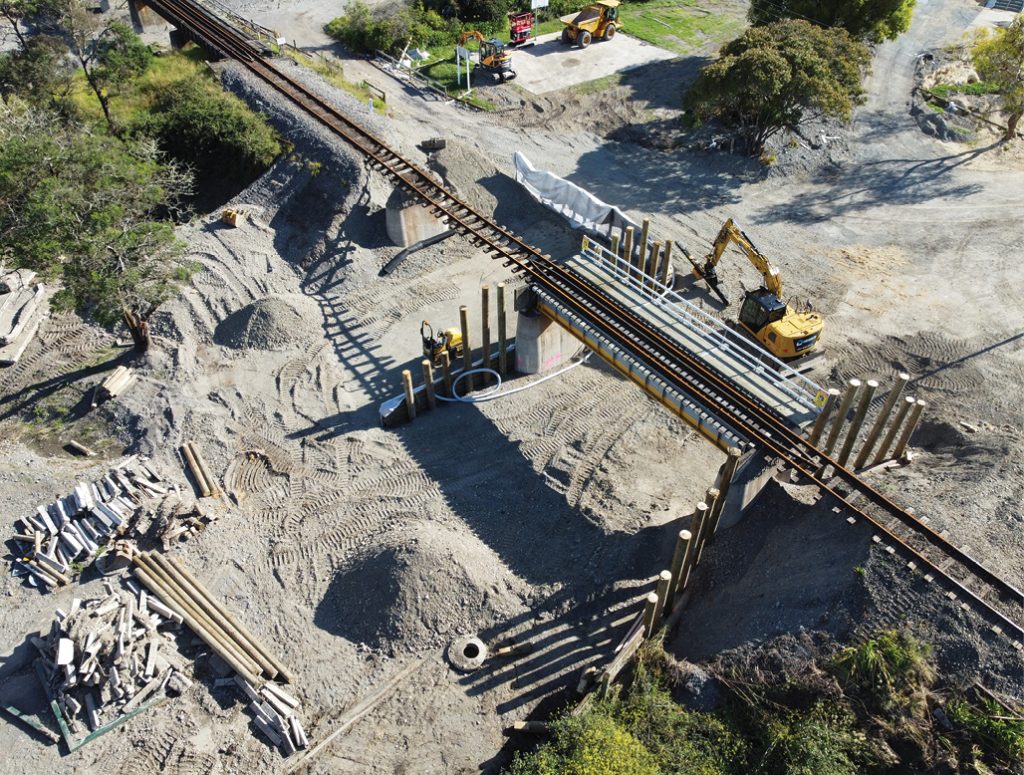
Figure 1 Bridge 176, Waipawa (photo credit, David Molnar)
By April 2023, the Palmerston North to Hastings section was again operational. The majority of the higher risk sites have been remediated and the remaining low and moderate risk sites are currently managed by a combination of risk mitigation measures. These include temporary speed restrictions, remote monitoring systems, and adverse weather triggered action response plans (TARPs). A supplementary remedial work bank is being developed to close out any remaining cyclone damage.
3. Hastings to Napier
The worst impacted asset in this area was the Waitangi Bridge (Br 217, Figure 2), which spans the Tutaekuri River near Clive. The flooding completely washed a 5 span section of the bridge away, as well as causing extensive damage to other spans, the approaches, rail embankments and up to 500 metres of formation on each side of the bridge. A temporary bridge is currently being designed which will allow the rail link between Hastings and Napier to be reopened, and enable work train access beyond this constraint in the line. The bulk of the design works is structural, however there are significant geotechnical aspects including embankment design and temporary pile design for the bridge foundations. Ground conditions are likely to be challenging, due to significant presence of estuarine, marginal marine and alluvial deposits.

FIGURE 2 Waitangi Bridge, Tutaekuri River (photo credit, Dennis Puia)
Complications have arisen due to contamination in the river, which have delayed dive squads from carrying out water-based inspections. Additionally, significant clean up works were required to remove the large amounts of accumulated flood debris, to allow construction plant to access the site.
4. Napier to Wairoa
The damage north of Napier is considerably more severe compared to the southern sections, and comprises a number of major to extreme damage sites. An initial helicopter survey was carried out in February allowing for a first pass damage assessment. Dozens of major and extreme damage sites were initially identified, with the highest concentration and most severe being located in the Esk River valley (Figures 3 and 4).

Figure 3 Eskdale region (photo credit, David Molnar)

Figure 4 Eskdale region (photo credit Audi Putra)
Just north of Napier, the track in the Eskdale area was severely impacted by the flooding, with greater than 100m sections of track completely gone, and/or far from their original alignment. Approximately 7kms of the PNGL runs through the low-lying areas of Eskdale, where up to 2m of a silt blanket has covered the railway line.
Further north into the Esk River valley, slope based geohazards are more prevalent, with numerous landslides, debris flows, culvert and embankment failures, landslide dams, and rockfall hazards. The challenging geological and topographical characteristics of the Esk Valley have resulted in a number of large-scale failures in difficult access areas. Geological literature indicates that steep linear hillslopes (leading to rapid runoff) and limited storage within the catchment are likely to contribute to large flood peaks (Kerry, J.L. 2003). Removal of native vegetation and increased pastoralism, along with the presence of soils prone to instability are also likely contributors to widespread slope failures. From Tutira northwards the damage becomes progressively less severe with increasing kilometrage towards Wairoa. Figures 5, 6, 7, 8 and 9 show typical damage observed.

Figure 5 – Typical culvert and embankment failure, Esk River valley (photo credit Audi Putra)
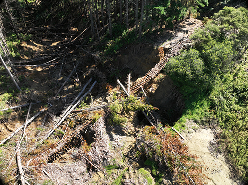
Figure 6 – Large scale embankment failure, Esk River valley (photo credit Audi Putra)

Figure 7 – Debris flow near Tutira (photo credit, David Molnar)
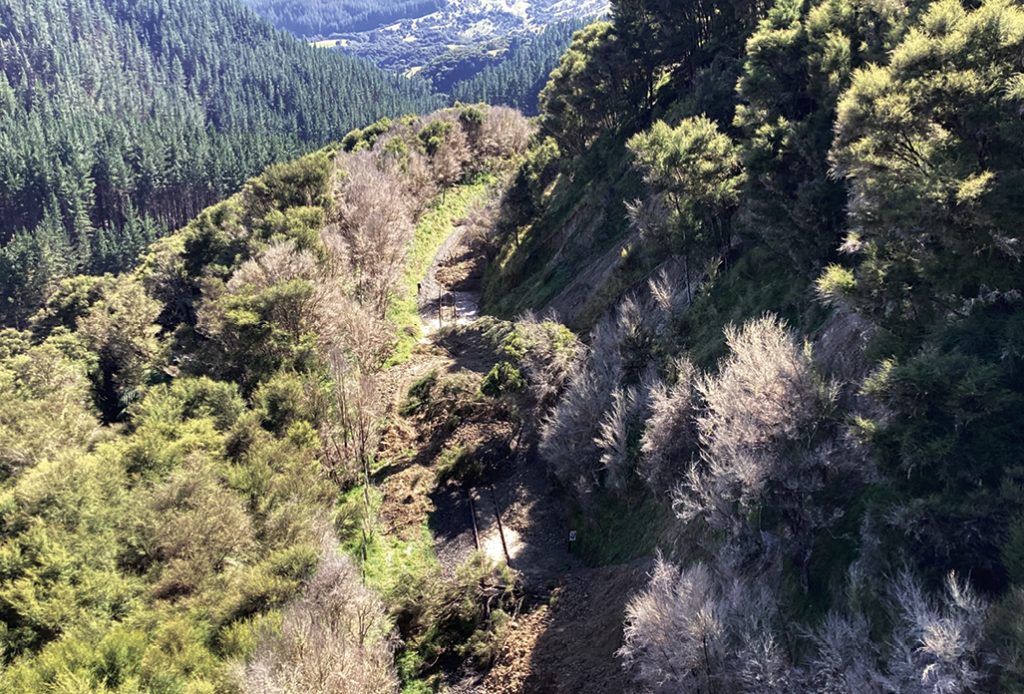
Figure 8 – Typical overslips, Esk River valley (photo credit, David Molnar)

Figure 9 – Above track / cutting hazards, Esk River valley (photo credit, David Molnar)
Due to access difficulties and much of the area being a high risk geohazard environment, the initial aerial-based assessment was used to triage the track into sections. This was supplemented by LiDAR and hi-resolution aerial imagery, which together allowed for the development of a field assessment and access plan. Initially, as most local roads north of Napier were closed, land-based field assessments commenced in Wairoa with hi-rail vehicles (provided from Bay of Plenty) and field teams being transported to Wairoa via helicopter. The plan was to progressively work southwards. Field teams were supported by the hi-rail vehicles where possible, and also by helicopter in the more difficult access areas. The more severely impacted Esk River valley was predominantly assessed via helicopter. This was mainly due to the high-risk environment and a large number of unpassable and prevalent culvert / embankment failures.
A number of the major to extreme rated damaged sites were also surveyed utilising UAVs by both KiwiRail and WSP.
All of the field damage assessment data was captured using ESRI Survey 123, with damage classified based on KiwiRail’s standardised Damage Classification guidelines.
5. Conclusions
While it has been devastating to see the impacts of the cyclone on the region, it has been positive seeing significant progress being made in reopening transport infrastructure, including both road and rail. The entire 295km of the PNGL between Palmerston North and Wairoa has been assessed in detail to date, all within two months of the cyclone occurring. This has been a monumental achievement, especially considering the logistical challenges faced by the assessment teams and KiwiRail staff. This has only happened due to the incredibly agile recovery team (both consultants and KiwiRail). As an added bonus, many were involved in the Kaikoura recovery, which has contributed to a more streamlined process.
The cyclone response has also necessitated creation of the Hawkes Bay Cyclone Recovery (HBCR) team and associated field operation centre based in Ahuriri, Napier. The project team have been incredibly busy interfacing with the large number of stakeholders, planning field assessment logistics, and management of field operations.
Another positive has been the rapid development of KiwiRail’s digital data capture strategies. Applying lessons learned from the response to previous large-scale events, such as the Kaikoura earthquake, and combining them with strategies developed for the delivery of CPAD projects has been especially beneficial for managing large amounts of field assessment data. Data management has been well supplemented by use of geospatial technology, data visualization and digital engineering, as well as PowerBi reporting and data analytics. Image 1 and Image 2 show typical reporting.

IMAGE 1 – Use of GIS to show damage distribution

IMAGE 2 – Example of PowerBi reporting
6. What’s next?
KiwiRail’s overall aim is to repair and reopen the PNGL between Napier and Wairoa. Based on the assessments to date, this goal is going to be a massive undertaking. There are many similarities to the Kaikoura response, however the geohazard types and modes of failures, along with potential remedial solutions are likely to be very different. KiwiRail will soon start the concept engineering and repair estimation phase, followed by more detailed designs and repair works.
An interim Alliance agreement has also been announced by Government, with a collaborative response to be carried out by both KiwiRail and Waka Kotahi NZ Transport Agency, supported by Downer, Fulton Hogan and Higgins. More on this will be developed in the coming months.
7. Acknowledgements
A large thanks to the consultants who have supported and assisted with the initial response: Aurecon, Stantec, Tonkin & Taylor and WSP.

