
ABSTRACT
South Dunedin is located on a small coastal plain that has formed over a drowned and subsequently infilled valley. Formerly a salt marsh formed behind sand dunes, South Dunedin has been progressively developed since 1840 and is now one of the most-densely populated areas in New Zealand. South Dunedin is vulnerable to surface flooding, as normal groundwater levels are close to the surface and in the future flooding may be exacerbated by sea-level rise. In addition, subsurface materials are considered prone to amplifying seismic shaking and susceptible to liquefaction.
In 2019, several organisations funded a variety of subsurface investigations in South Dunedin to determine geotechnical properties, groundwater properties and geometry of the valley-infill. Sixteen CPT tests were carried out and shallow piezometers installed at 8 of these sites. Three deeper boreholes were drilled to determine the thickness of sediment and deeper-level groundwater conditions. Other existing borehole and CPT data have been collated as they have become available. Geophysical methods were used by University of Otago to investigate the dynamic characteristics of the subsurface materials.
Results of the investigations and groundwater data will be used in seismic hazard and liquefaction analyses and will inform a groundwater model. An interpretive 3-dimensional geological model of the valley subsurface geometry has been generated and this will improve the ability of the NZSeaRise programme to analyse the impacts of various sea level rise scenarios on the groundwater, future surface flooding, and infrastructure.
INTRODUCTION
Background
South Dunedin (Fig. 1) is built on 600 ha of flat coastal plain, most of which is less than 3 metres above mean sea level (Fig. 2). The coastal plain, a salt marsh behind dunes prior to European settlement, was formed over an infilled river valley. Since colonisation in 1840 the salt marsh has been progressively developed and is now one of the most-densely populated areas in New Zealand.
The area is subject to several natural hazards (Glassey et al. 2003, Goldsmith & Hornblow, 2016) including surface flooding, being flat, close to sea level and with groundwater close to the surface. In addition, subsurface materials have been identified as amplifying seismic shaking (Bishop 1974) and have been considered susceptible to liquefaction (Murashev & Davey 2005, Barrell et al. 2014). The depth of poorly consolidated sediment infill beneath South Dunedin has long been a matter of uncertainty and debate. Few drill holes reach bedrock, and sediment depth estimates have relied largely on indirect measurement and interpretation from geophysical surveys (resistivity, gravity and seismic).
In June 2015, a rainfall event that was both heavy (144 mm) and intense (9-12 mm/hr) caused NZ $40 million damage through flooding. In places the stormwater network was over-run and ponding of surface water occurred. Shallow groundwater levels also play a role in local flood hazard (ORC 2015). The Parliamentary Commissioner for the Environment noted that South Dunedin has around 2700 homes < 0.5 m above the spring high tide mark (asl), twice as many at-risk dwellings than in any other New Zealand coastal urban centre (PCE 2015). In addition, 12 schools, early childhood centres, a stadium, parks and sports grounds, together with electricity substations, the city’s main wastewater treatment plant, a stormwater pumping station, fuel storage depots, and many large commercial and public buildings all situated on land < 3 m asl. Main arterial roads and critical trunk sewerage and stormwater pipes add further to the assets at risk.
The Parliamentary Commissioner for the Environment also identified South Dunedin to be at risk from increased coastal flooding as a result of sea-level rise (PCE 2015). The local government is now facing difficult decisions about the sustainability of this low-lying coastal community in terms of levels in investment and protection of this area. While these are fundamentally social and economic issues, decisions around them must be informed by rigorous technical assessments and investigation and more extensive monitoring systems.
Geological setting of South Dunedin
The bedrock geology of South Dunedin and the surrounding area is comprised of Early Miocene Caversham Sandstone and Late Miocene volcanic rocks of the Dunedin Volcanic Group (Benson 1968, Bishop and Turnbull, 1996, Barrell et al., in prep). Caversham Sandstone outcrops in the Caversham Valley area, while the overlying Dunedin volcanic rocks form the hills surrounding the harbour and South Dunedin. Beneath South Dunedin, Quaternary sediments, comprising sands and silts deposited under marine to estuarine conditions, and sandy and gravelly stream sediments are thought to be as much as 70 m thick. Large accumulations of dune sand have formed along the southern coast providing a topographic barrier between the Pacific Ocean and South Dunedin.
South Dunedin has formed, in geological terms, very recently. During the most recent glacial period, which peaked about 18,000 years ago, sea level was at least 120 m lower than present and the coastline as much as 35 km offshore. At that time, the Water of Leith (Fig. 1) catchment is thought to have drained to the Pacific Ocean through the area now occupied by South Dunedin, via a broad valley.
Following the peak of the last glacial period, sea level began to rise, reaching its present level about 7,000 years ago. A dune barrier formed between St Clair and Lawyers Head (Figs. 1, 2) and fine sediments accumulated in the sheltered water at the head of the harbour. Sediment accumulation eventually built up to just above sea level in South Dunedin producing salt marsh that has, since colonisation in the 1840s been levelled with a thin (~1 m) veneer of placed fill and developed.
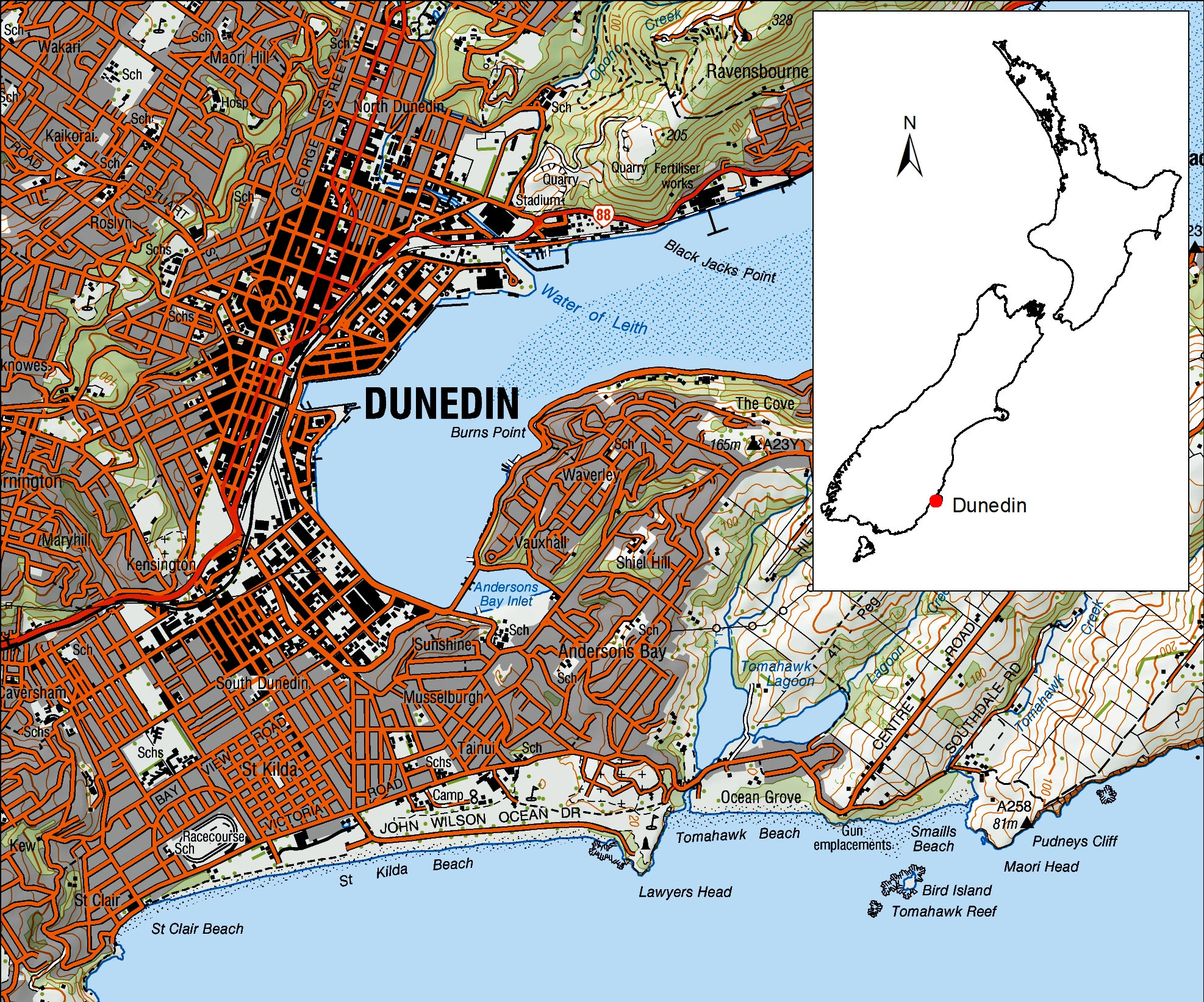
Figure 1: Location of South Dunedin (circled). 
Figure 2. Topographic elevation model for South Dunedin generated from a 2009 LIDAR survey.
SCOPE OF STUDY AND INVESTIGATIONS
Otago Regional Council (ORC) is developing a multi-hazard Climate Change Adaptation Plan for the South Dunedin area. ORC is being assisted by several organisations with associated supporting activities such as an expanded groundwater monitoring network, greater definition of the sediments beneath South Dunedin, an understanding of seismic risk and long-term subsidence rates. In addition, updated groundwater flow models for South Dunedin will help assess the impacts of rising sea level on the local coastal aquifers. The investigations described here will inform stormwater management, climate change and natural hazards adaptation decisions for South Dunedin, including the replacement of the stormwater and waste water infrastructure in South Dunedin over the next five to 10 years.
The South Dunedin area is a case study for the NZSeaRise research programme, which has 5 years of funding (2017-2022) to assess impacts of predicted sea-level rise throughout New Zealand, including groundwater flooding on coastal plains. A pre-existing groundwater model for South Dunedin (Rekker 2012) is relatively simplistic, assuming homogeneous sediments throughout the area and calibrated on just four shallow (~6 m deep) groundwater monitoring bores. Prior to the NZSeaRise drilling programme of 2019, few drill holes reached bedrock beneath the sediment infill. One of the project aims is to develop an improved subsurface geological and groundwater model, to more-effectively model the influence of sea level rise on groundwater.
The main purpose of this paper is to describe the development a 3D geological model for South Dunedin which will be incorporated into a broader Dunedin Urban Geological map (Barrell et al. in prep) being produced by GNS Science under the RGMAD Urban programme. The investigations and groundwater monitoring will also be used in seismic hazard and liquefaction analyses and modelling the impacts of sea-level rise on groundwater and surface flooding.
Previous work
Previous work in South Dunedin includes a 1993 seismic hazard study funded by The Earthquake Commission (EQC – McCahon et al. 1993). Available drill hole data were collated, but none of these holes reached bedrock and so were of limited interpretive value. The report also included a resistivity survey, the data from which were used to make an interpretive map of the thickness of sediment beneath South Dunedin. Stephenson & Barker (1999) investigated South Dunedin for seismic wave resonance using microtremor measurements and four Cone Penetrometer Test (CPT) measurements.
Some commercially-funded geotechnical investigations in South Dunedin (Fig. 3) were made available for this project, including 2005 and 2009 investigations from the Tahuna Wastewater treatment plant, 2009 investigations from the Bunnings Warehouse site and 2016 investigations from the Edgar Centre sports complex. These investigations provide information > 6 m depth and intercept bedrock at Tahuna and Bunnings (Fig 3).
Investigations 2019
In 2019, several organisations funded a variety of subsurface investigations in South Dunedin to determine geotechnical properties, groundwater and geometry of the valley-infill (Fig. 3). The “QuakeCore” consortium (Universities of Canterbury and Otago, EQC, GNS Science, ORC and Dunedin City Council) funded 16 CPT soundings across South Dunedin and installed shallow piezometers at 8 of these sites. ORC and Oceana Gold, along with the NZSeaRise research programme, funded 3 deeper drill holes with core recovered by sonic drilling to determine sediment types and thicknesses, depth to bedrock and deeper-level groundwater conditions. Geophysical methods have been used in University of Otago post-graduate student projects to investigate subsurface characteristics (Rees 2018, Lutter 2018, Sangster, 2019). The subsurface data have been collated into a database and drill logs have been made available on the NZ Geotechnical Database.
GEOLOGICAL MODEL OF SOUTH DUNEDIN
Existing and new subsurface data has been analysed and allowed for reinterpretation of the geology beneath South Dunedin and an updated geological model to be developed.
Characteristics of subsurface materials
The drill hole logs, CPT data, and radiocarbon dating have enabled a two-layer interpretation of the South Dunedin Quaternary sediment infill. In addition, those drill holes that reached bedrock have provided new knowledge of the distributions of Caversham Sandstone and Dunedin Volcanic Group bedrock under South Dunedin. Co-located drill holes and CPT probes afford insights to the interpretation of CPT data at other locations where there are no nearby drill hole data.
Barrell (2002) considered that two distinctive Quaternary sediment packages can be recognised in drill holes in the Dunedin port area, and under South Dunedin. The younger package is associated with the post-glacial marine transgression (Holocene sediments). These sediments are predominantly silt-clay of moderate to high plasticity, with colours ranging from dark grey to grey brown, in some places containing shells and sand layers. The sediments have a distinctive CPT values indicating very low strength. Radiocarbon dating of organic material from drill core at two locations, the Edgar Centre (Fig. 3) and De Carle Park (site CE17/0106, Fig. 3) has confirmed early to mid-Holocene ages at 20 m and 11 m respectively.
The underlying sediment package (‘Pleistocene’ sediment) is generally distinguished by difference in colour, with a prevalence of various yellow or brown tones, low to no plasticity, and an increase in CPT strength. These sediments vary in composition. They include sub-rounded gravels (volcanic provenance), sands and silts. Minor components may include wood fragments and diffused or layered dark organic material. Radiocarbon dating has returned ages beyond the range for the method (i.e., older than ~50,000 years). This sediment package is interpreted to be predominantly of terrestrial alluvial origin, including colluvial components near the slope bound margins.
Further subdivision of the sediments, for example into facies that may possibly represent interglacial and glacial period deposition (Rees 2018), has not been possible as existing drill hole information across South Dunedin is too sparse, or inadequately detailed, to allow that degree of interpretation across the entire 3D geological model.
In the eight drill holes where it is encountered, bedrock is either Dunedin Volcanic Group or Caversham Sandstone. The volcanic materials include slightly to highly weathered lava and breccia and highly weathered fine-grained volcanic silt-clay. In drill core it is not always possible to confidently distinguish whether weathered volcanic material is in-situ volcanic rock or volcanic-derived alluvial sediments.
The volcanic bedrock has been eroded in parts so that the Quaternary sediments rest directly unconformably on Caversham Sandstone. In drill hole CE17/0105 (Fig. 6), the upper part of the Caversham Sandstone is a highly weathered, very soft and moderately to highly plastic clay-silt but becomes less weathered and sandier with depth. Caversham Sandstone has a distinctive calcium-rich chemistry, with its matrix typically comprising about 60% CaCO3 in less weathered rock. In drill core where it was uncertain if the material was weathered Caversham Sandstone or Quaternary sediments, such as at the Edgar Centre, testing with weak hydrochloric acid and portable XRF probing has aided identification.
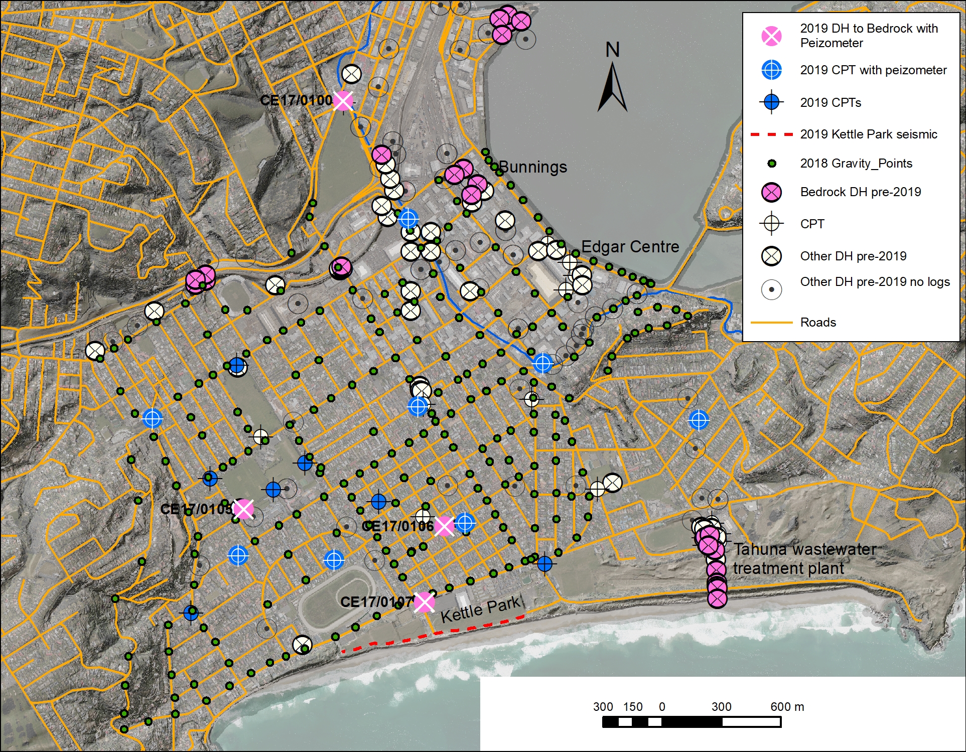
Figure 3: Subsurface investigation data points used in the South Dunedin project.
Subsurface geometry and geological model
One of the aims of the 2019 drilling was to establish the depth and character of sediment beneath South Dunedin. On the basis of resistivity soundings, McCahon et al. (1993) previously postulated the existence of a buried river valley with a base about 70 m deep (Fig,4). Sangster (2019) used modelling of passive and active seismic waves to interpret Quaternary sediment depths and determined a mean depth of 29 m and a maximum depth of 86 m, and that in most places these sediments rest on Caversham Sandstone. Sangster (2019) also re-examined the Lutter (2018) gravity survey data (Fig. 4) – the Lutter gravity survey interpreted sediment depths about twice the depth indicated by other methods. A feature of the Sangster (2019) and Lutter (2018) geophysical models is that they depict closed basins, without a definitive paleochannel (Fig 4.).
The three new deep drilling sites (Fig 4) encountered bedrock at 12.7 m, 16.2 and 17.3 m, compared to depths of 20 – 50 m anticipated from geophysical modelling. The drill hole data are regarded as the most reliable, despite some interpretive challenges such as determining whether volcanic rock material recovered by drilling is from in-situ bedrock or from coarse gravelly sediment. CPT data are treated here as the next most reliable information set, particularly for differentiating the Holocene from the Pleistocene sediment packages. Of the geophysical data considered in the modelling, most weight is given to gravity anomalies followed by the seismic reflection or refraction profiling.
The geological model presented here (Figs. 5 and 6 – developed in LeapFrog Geo® software) places key importance on the geological process environment. Fluvial erosion is assumed to have been the primary agent that shaped the geometry, with sediment architectures reflecting an interlayering of fluvial and coastal in response to offshore sediment supply systems. The model takes the deepest drilled depth of Quaternary sediments (at least 52 m below present sea level), between the Bunnings and Edgar Centre localities; Fig. 3) and assumes a channel of at least this depth must continue southwest and beyond the present coast.
The absolute depths of sediment determined from gravity profiles (Sangster 2019) have not been adopted but we have interpreted features delineated by the anomalies, such as relatively shallow bedrock under Kettle Park. Two of the 2019 drill holes (Fig. 4) intersected this bedrock platform (CE17/0106, CE17/0107), while the western drill hole (CE17/0105) is situated at the margin of the main trough (Fig. 5). From these considerations, a structure contour map was drawn on the base of the Quaternary sediments (Fig. 5), and then imported into LeapFrog Geo software for rendering and manipulation in a digital 3D environment.
CPT data indicate that the base of the Holocene sediment is relatively shallow across the western part of South Dunedin (Fig 6.), but much deeper near the Edgar Centre. The model therefore extrapolates the Holocene trough south through the eastern margin of the South Dunedin plain (Fig 6). This model infers that the Holocene channel has migrated away from the deeper Quaternary channel. Both these modelled surfaces (base of Holocene and base of Quaternary) will require further refinement.
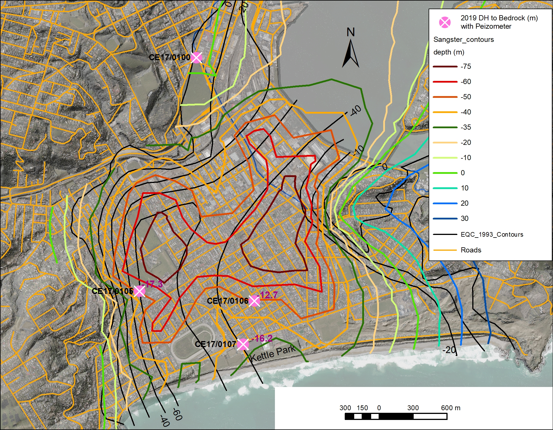
Figure 4: Contours on the depth of Quaternary sediment in the south Dunedin by Sangster 2019 (coloured), from McCahon et al., 1993 (black). The depth to bedrock (Dunedin Volcanics) at the 3 deeper holes drilled in 2019 as part of this study (pink circles with white cross) are shown.
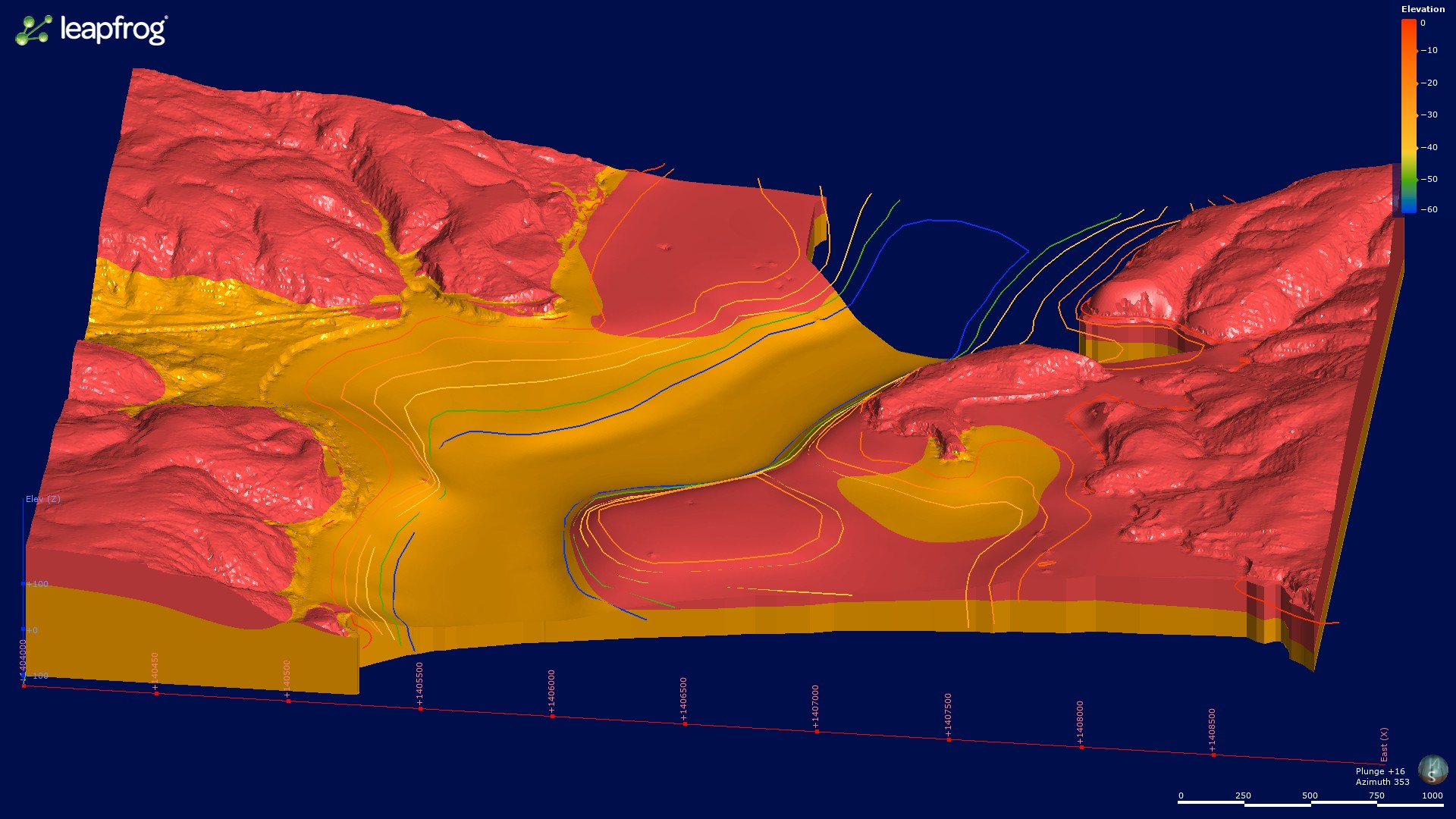
Figure 5: Perspective view of the base of the Quaternary sediments with structure contours (values given as elevation top right), showing the bedrock (volcanic in pink and Caversham Sandstone in orange) surface beneath South Dunedin.
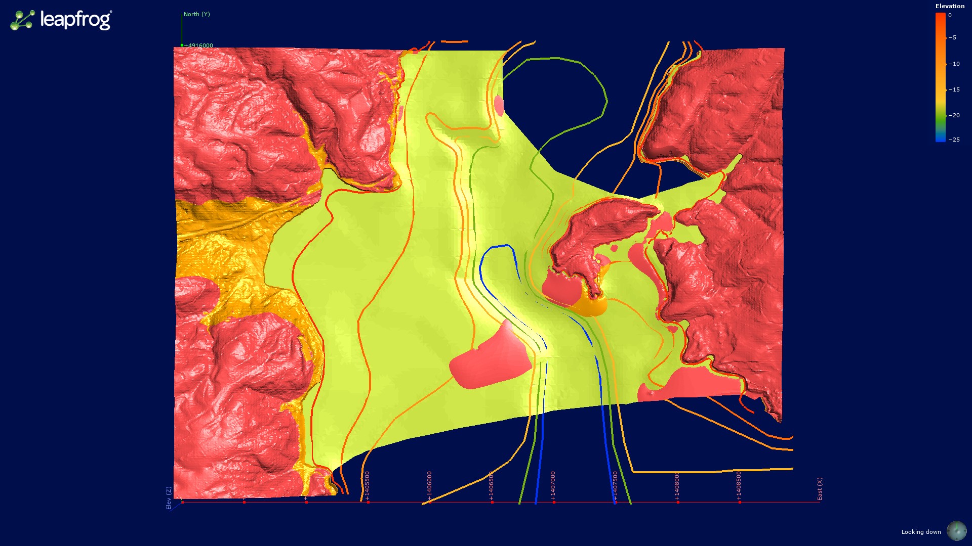
Figure 6: Plan view of the base of the Holocene sediments with structure contours (values given as elevation top right), South Dunedin. The Quaternary sediments are shown in yellow-green with the volcanic bedrock in pink and Caversham Sandstone in orange.
Hazard implications
Seismic Amplification
Stephenson et al. (1999) found that only a small part of the sediment in the east exhibited a resonant basin response and considered this part of an infilled channel. They concluded that “the soil materials in the resonant part of South Dunedin are mostly weak, cohesive and non-liquefiable. However, because of their weakness they are likely to exhibit ground damage effects other than liquefaction when subjected to strong shaking”. Bishop (1974) identified amplified earthquake shaking in parts of south Dunedin and the maximum extent could be related to deeper parts of the sediment stack as depicted in the deeper channel shown on Figure 5. However, Bishop (1974) inferred that this might have been related to edge effects, especially along the western edge, that caused amplification of certain frequencies (Stephenson et al., 1999, Murashev & Davy 2005).
Sangster (2019) updated p-wave (Vp) and s-wave (Vs) seismic velocities of the materials below South Dunedin and considered that the velocities between 50 and 100 m depth are significantly slower than previously determined by McCahon et al. 1993. This may be because of the weathered nature of the bedrock as encountered in drill holes. Site periods are significantly shorter near the western hills and increase toward the harbour, as the depth to bedrock increases and along the axis of the inferred paleochannel. The results of this study may be useful in future ground motion simulation work.
Liquefaction
Near-surface Holocene sediments in the South Dunedin have been considered as susceptible to liquefaction (Barrell et al. 2014 and Murashev & Davey, 2005, McCahon et al. 1993 et al.) as they inferred relatively unconsolidated, saturated silts and sands. Stephenson et al. (1993) considered them non-liquefiable. Preliminary Boulanger and Idriss (2014) analysis of the CPT soundings being prepared for the ORC (Ben Mackey pers. comm. April 2020) indicate that the sediments, except in a few places, are not highly susceptible to liquefaction as the near surface Holocene materials are cohesive, clayey, with moderate to high plasticity.
Flooding
Cox et al. (in prep) have analysed groundwater data across South Dunedin and determined that the for the most part groundwater levels are between 0 and 1 m below the ground surface. No confined groundwater was encountered in the drill holes. The response and spatial variation of the groundwater to sea level rise is partly dependent on the characteristics of the sediments. Utilising the data from the 2019 piezometric network the existing groundwater model (Rekker 2012) will be updated and used to model groundwater changes under different future sea level scenarios.
CONCLUSIONS
Existing and new drill hole and CPT information for the South Dunedin area have been collated together with data from geophysical surveys, then used to develop a new 3D geological model of subsurface geology under the South Dunedin coastal plain. It is interpreted that a drowned valley, with two former channel axes are present based on the premise that drainage passed through South Dunedin during glacial peaks. A deeper and older western channel has cut into the bedrock, and a shallower and younger eastern channel marks Holocene in-filling following the last glacial maximum sea level rise. It is intended that this model will form a basis for future modelling of the groundwater systems, seismic behaviour and potential geological hazards in the South Dunedin area, to inform planning, hazard analysis and approaches to managing the effects of future sea-level rise.
ACKNOWLEDMENTS
The authors would like to acknowledge Oceana Gold and Oliver Rees (OU) for their contribution to the drilling, the contributors to the CPT campaign (Quake Core, Canterbury University, Otago University, DCC, EQC, ORC and NZSeaRise. We would like to thank the DCC and consultants that provided geotechnical data and Otago University for the geophysical work. Mark Rattenbury and Simon Cox of GNS Science provided insightful reviews of the paper.
REFERENCES
Barrell, D.J.A. 2002. Geological stability assessment of the Port Otago tide gauges, Otago Harbour, New Zealand. Lower Hutt: Institute of Geological & Nuclear Sciences Limited. Institute of Geological & Nuclear Sciences science report 2001/21. 19 p.
Barrell, D.J.A., Glassey, P.J., Cox, S.C. & Smith Lyttle, B., 2014. Assessment of liquefaction hazards in the Dunedin City district. GNS Science Consultancy Report 2014/068. Report prepared for Otago Regional Council.
Barrell, D.J.A., Glassey, P.J., & Smith Lyttle, B., in prep. Geological map of the Dunedin urban area. GNS Science Geological Map Series.
Benson, W.N. 1968. The W.N. Benson geological map of Dunedin district – Scale 1:50,000. New Zealand Geological Survey Miscellaneous Series Map 1. Wellington, Department of Scientific and Industrial Research. 1 folded map and notes (18 p.).
Bishop, D.G., 1974. The Dunedin Earthquake, 9 April 1974. Part 2: Local Effects. Bulletin of the New Zealand National Society for Earthquake Engineering, vol 7, no. 3.
Bishop, D.G. & Turnbull, I.M. (compilers). 1996. Geology of the Dunedin area. Institute of Geological and Nuclear Sciences 1:250 000 Geological Map 21. Lower Hutt, GNS Science. 52 p. and one folded map.
Boulanger, R.W. & Idriss, I.M. (2014). CPT and SPT Based Liquefaction Triggering Procedures. Department of Civil & Environmental Engineering, University of California.
Cox S.C., Ettema M., Mager S.M., Glassey, P.J, Hornblow, S. & Yeo S. in prep. Dunedin Groundwater Monitoring and Spatial Observations. Lower Hutt (NZ): GNS Science. (GNS Science report). doi:10.21420/
Glassey P, Barrell D, Forsyth J, Macleod R 2003. The geology of Dunedin, New Zealand, and the management of geological hazards, Quaternary International 103: 23–40.
Goldsmith, M. & Hornblow, S. 2016: The natural hazards of South Dunedin. Otago Regional Council report, July 2016.
Lutter, J.L. 2018. 3D Gravitational Inversion Modelling of the South Dunedin Sub Basin, Otago, New Zealand, MSc thesis, Geology Department , University of Otago.
McCahon, I.F., Yetton, M.D., Cook, D.R.L. 1993. The Earthquake hazard in Dunedin. Soils and Foundations EQC research project 91/56.
Murashev, A.& Davey, R. 2005. Seismic Risk in the Otago Region. Opus International Consultants Limited Report SPT: 2004/23, prepared for Otago Regional Council. 50 p., 27 maps and 2 appendices.
ORC 2015.Coastal Otago flood event 3 June 2015. Otago Regional Council. ISBN 978-0-908327-19-4. 56 pages.
PCE, 2015. Preparing New Zealand for rising seas: Certainty and uncertainty. Parliamentary Commission for the Environment report, November 2015.
Rees, O.W., 2018. Seismic characterisation of Otago Harbour sediments tied to a carbon-dated core record. BSc (Hons) thesis, Geology Department, University of Otago.
Rekker, J. 2012. The South Dunedin Coastal Aquifer & Effect of Sea Level Fluctuations. Technical report, Otago Regional Council.
Sangster, C., 2019. Dunedin rock and roll: 3D seismic wave velocity modelling for seismic hazard analysis. MSc thesis, Geology Department , University of Otago.
Stephenson, W.R., & Barker, P.R., 1999. Resonant amplification of earthquakes – a potential basin in South Dunedin. Institute of Geological & Nuclear Sciences science report 99/13, 59 p.