
UC Geologists key contributors to fault rupture mapping following the M7.8 Kaikoura Earthquake
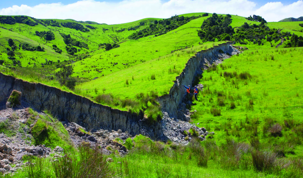
Above: The “Woodchester Wall” South Leader fault rupture scarp (Photo – Kate Pedley).
Since 14 November 2016 a large team of staff and postgraduate students from the Department of Geological Sciences have been working long hours to support the science response to the massive Kaikoura Earthquake. Our team has focussed on capturing fault ground rupture data from the epicentral region in north Culverden basin, near Waiau Township and from there to the NE toward Kaikoura. The complex array of ground ruptures extends into the more remote and rugged topography of the upper Leader River catchment and to the NE along the eastern range front of Mt Stewart to the Charwell area along the Inland Kaikoura Road.
While in the first few days after the earthquake we were undertaking field reconnaissance, that quickly moved on to detailed mapping using RTK, GeoXH and total station surveys to document fault zone ground ruptures location and offsets. We have also deployed our drone to capture video and photo imagery to developed detailed fault zone ground rupture maps. Even now some six months after the earthquake we continue to locate new fault ruptures in the more remote parts of the region as the LiDAR survey coverage has just been made available. To date our team has documented more than 100 km of fault ground ruptures.
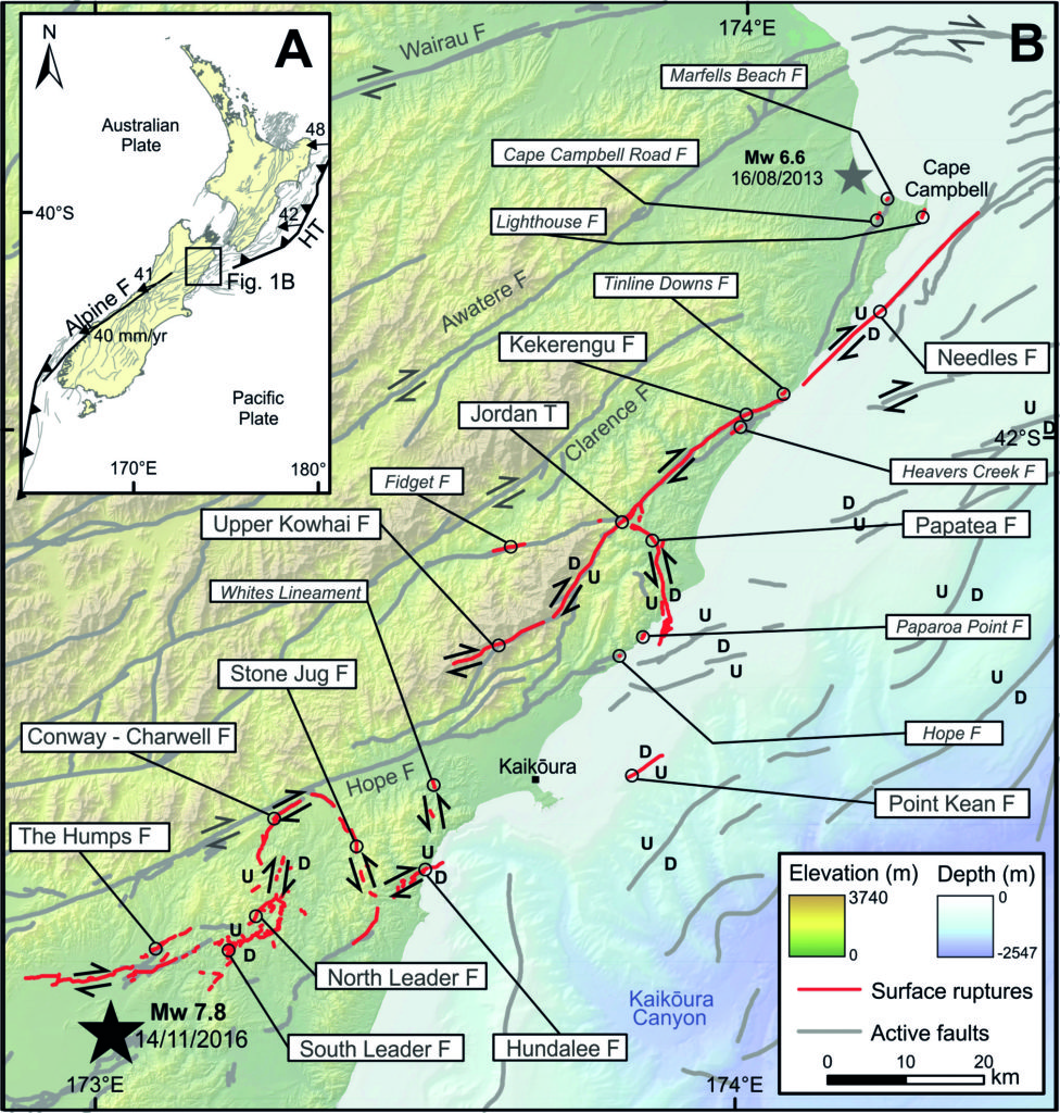
Above: Mapped fault ruptures as of press time (courtesy GNS Science).
Overview of Ground ruptures
In the area we have covered a number of faults have ruptured in a complex relay extending from the NW margin of Culverden basin to the NE, toward Kaikoura. The SW tip of the coseismic ground ruptures is located in the Amuri Range west of the central Emu Plain. Detailed mapping has documented a series of sub-parallel NE to ENE trending fault rupture splays of the Humps Fault Zone with predominantly dextral strike-slip offsets cutting across the extensive low angle alluvial fans sourced from the various catchments on the adjoining Amuri Range. The ground rupture zone is characterized by a Reidel shear pattern indicative of rupture through near-surface granular alluvial deposits. There are also a number of antithetic oblique sinistral Reidel shears, some with decimetre scale displacements extending up to 100’s metres from the principal shear zone. We have noted these are most prominent at splay step-overs.
In the Lower reaches of the Lottery and Mason Rivers, north of Waiau Township, we have identified two main fault rupture zones within the Humps Fault Zone. These are provisionally named the Willow Bank Strand (west of Lyndon Rd) and the Glenbourne Strand (east of Lyndon Rd). Both are characterized by oblique dextral strike-slip. The most prominent Glenbourne splay extends to the NE into the upper Leader catchment area near Woodchester Station. Here the Humps Fault Zone links with the more northerly trending South Leader and North Leader Faults.
A spectacular ground rupture has been documented from the South Leader Fault with an oblique sinistral slip of up to ~3.5m south of the Leader River. To the north, the North Leader Fault is accompanied by a ~2km wide zone of complex deformation and multiple ground rupture splays. Fault traces are often co-mingling with landslide scarps in the hillslope topography making fault zone delineation an interesting and challenging process. The main ground surface displacement zone coincides with the eastern range front of Mt Stewart; here we have documented up to ~4.5m of vertical offset of along the oblique thrust defining the principal fault zone.
Ground ruptures extend to the North and northeast from Mt Stewart range front to immediately west of the area where the Inland Kaikoura Road crosses the Conway River. The fault ruptures relay into a NE trending dextral oblique-slip fault located 1-2 km south of and trending parallel to the Hope Fault. In turn from east of the nearby Charwell River the coseismic fault rupture relays to the SE on the sinistral Stone Jug Fault, connecting in turn onto the Hundalee fault.

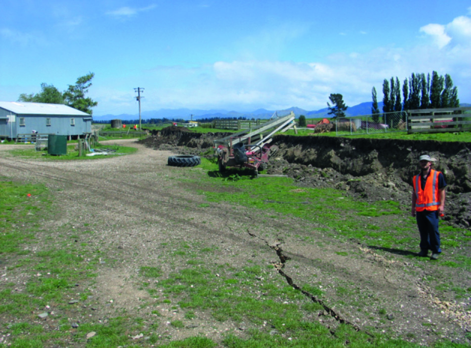
Above: Oblique transtensional fault cutting SH70 – Inland Kaikoura Road, dextral shear ~2.2m graben ~1 to 1.5m vertical offset (photo – Jarg Pettinga))
Above: Oblique slip dextral fault scarp – Glenbourne Woolshed (photo – Jarg Pettinga)

Rare class fieldwork opportunity for Geology students following the November 2016 Mw7.8 Kaikoura Earthquake
Students enrolled in the Geology and Engineering Geology programmes have taken advantage of a most unusual opportunity – gaining new field mapping skills documenting some of the fault ground ruptures and large landslides that were formed during the November 14th earthquake.
Both undergraduate and postgraduate geology classes were out in the field in March mapping fault ruptures east of Waiau township and near Woodchester Station in North Canterbury. The fault scarps mapped by students are part of a very complex zone of faults that extend more than 180 km across North Canterbury to East Marlborough and then offshore. Seeing and learning how to record and interpret the complexity of the ground surface ruptures and associated zones of deformation, as well as linking the structural detail of fault zone geometries with the landforms and geomorphology represent a rare opportunity.
The Professional Masters in Engineering Geology class has also taken advantage of the unique opportunity for gaining fieldwork experience mapping the active fault ground ruptures as well as documenting and interpreting the hazards and risk scenarios associated with a huge landslide dam blocking the Leader River.

Above: Oblique reverse left lateral ground rupture of the South Leader Fault Zone. (Photo – Kate Pedley)
Summary
While the impact of the main M7.8 Kaikoura Earthquake and subsequent many moderate to large magnitude aftershocks has had a devastating effect on communities such as Waiau and Kaikoura as well as the regional lifeline infrastructure, we are also seeing the severity of impact on the farmers in the region. On-farm facilities such as stockyards, woolsheds, feed supply silos, farm access tracks and water supply pipe network are posing ongoing challenges for farmers. Our field mapping data will be an important part of the recovery strategy and decision-making over the coming months.
Scientifically we are generating a vast new database which will underpin future research both in terms of earthquake hazard assessment as well as a better understanding of the geologically driven landscape evolution of the NE South Island plate boundary zone. Already it is clear that this event is of global significance, the sheer scale and complexity of fault rupture, the impacts on our natural environment and the crustal dynamics involved will mean a lasting legacy of new insights into the geological and seismological processes in active tectonic regions straddling obliquely collisional plate boundaries.
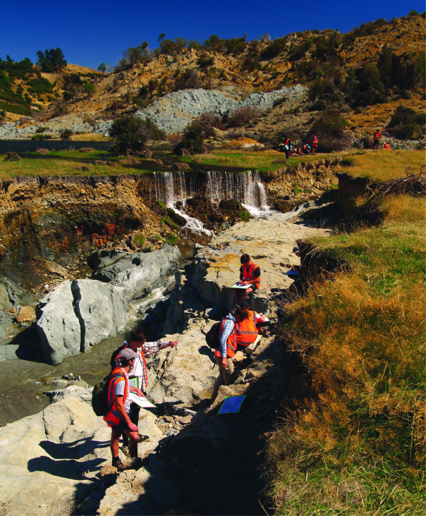
Above: Postgraduate Engineering Geology class mapping a fault rupture in a new bedrock exposure created by flood erosion as Lake Rebekah overtopped the toe of the Leader River Landslidedam (background) (Photo – Clark Fenton)

Save