Relative sea level (RSL) change data in New Zealand are scarce and fragmented (Clement, et al., 2016). Direct metrics on RSL change and vertical land movement (VLM) in Raglan Harbour are not fit for purpose due to a 25% absence of tide gauge data since records began in 2008. This was partially due to a delay in the replacement of a tide gauge after a fire at the Raglan Wharf in 2010. No significant RSL change is apparent within the available data (Waikato Regional Council, 2023).
The nearest GNSS VLM measuring station is located around 12 km away on the opposite side of major N-S trending faults associated with the up-lifted Hakarimata range. Consequently, robust data on which to model VLM within the harbour are largely absent.
A number of recent studies address stratigraphic nomenclature within the harbour (Tripathi, et al., 2008). However, structural architecture mapping of the harbour is limited to the recording of large-scale faults (Waterhouse and White, 1994).
A number of localised faults identified during my MSc (Carter, 2003) and geotechnical fieldwork are not recorded within published literature. My field observations indicate that significant VLM has occurred throughout the harbour within the last 20 Ka and that this was probably ongoing in an intermittent manner within the last 1 Ka.
Multiple published studies address VLM of the Nth Island west coast through correlation of marine terraces with Pleistocene glacial-driven eustatic sea level curves. These studies focused on terraces of elevations ranging from 7 m to 100 m AMSL. Due to the advanced age of these paleo-foreshores, datable fossils are largely absent. Little attention was paid to terraces at low elevations, or their potential to establish more recent VLM (Ryan et al., 2021).
With exception of a recent VLM model created by the NZ SeaRise program, all relevant studies compiled since 1971 conclude an average uplift rate of the Raglan coastal region of 0.25 to 1 mm/year throughout the last 150 Ka (e.g., Ward, et al., 1971; Chappell, 1975; Pillans, 1990; Claessens, et al., 2009; Beavan and Litchfield, 2012; Clement, et al., 2016).
NZ SeaRise reports subduction of 1.0 to 3.4 mm/year at various locations around the Raglan Harbour foreshore (NZ SeaRise, 2022). This finding is in contrast with the bulk of published literature and my geological observations within the harbour.
Low-lying foreshore terraces are common throughout Raglan Harbour. These range in elevations of 0.6 m to 1 m above the modern high tide strandline. Preliminary reconnaissance has established a high incidence of residual marine macrofossils embedded within the terrace sediments (Plate 1). Intact shells are common, indicating that these are not anthropogenic middens (Plate 2).

Plate 1: A fossil-rich marine terrace embankment at ~ 1 m above the modern high tide strandline

Plate 2: Intact shells at an elevation of 0.8 m above the modern strandline at the boundary between Whaingaroa Siltstone and a tide zone sedimentary bed
Rafted pumice beds near the marine terrace – topsoil contact are present at some locations (Plate 3). The origin and age of this pumice is as-yet unknown.
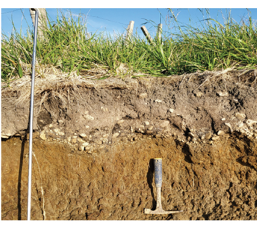
Plate 3: Rafted pumice at the marine sediment – topsoil contact. Height above modern strandline: 0.9 m
Modern and paleo tidal nick points within limestone foreshore outcrops are apparent at multiple locations. A comparison of the modern high tide nick points with historical photos dated 1910 indicate that there has been no significant RSL change over the last 110 years (Plate 4).

Plate 4: A tidal erosion zone comparison, spanning 112 years
There is further proxy evidence that uplift has been ongoing over the last millennial. These include shell middens near the shore of a freshwater swamp with evidence that it has been tidal within the last 1.2 Ka.
The objective of this study is to establish the validity of a hypothesis that differential uplift in and around Raglan Harbour over last millennial has been significant. It will also investigate evidence that this mechanism has been active within the last millennial.
Carbon dating of shell material will be the prime evidence on which an uplift model will be constructed. This will be supported by thermoluminescence dating of sediments and pumice analysis. All terraces will be mapped, along with stratigraphic and sediment analyse at key sections.
The implication of a prospective hypothesis validation would cast doubt on the common perception that the Raglan Harbour foreshore properties will be increasingly at risk from RSL rise over the near to long-term future.
References
Beavan, R.J. and Litchfield, N.J. (2012). Vertical land movement around the New Zealand coastline: implications for sea-level rise. GNS Science Report, 2012/29.
Carter, M.J. 2003: The mid-Tertiary Te Kuiti Group in the Aotea Harbour region: a re-evaluation of stratigraphic relationships and nomenclature, Unpublished MSc. thesis, lodged in the Library, University of Waikato, Hamilton, New Zealand.
Chappell, J. (1975). Quaternary warping and uplift rates in the Bay of Plenty and west coast, North Island, New Zealand. New Zealand Journal of Geology and Geophysics. Volume 18, 1975 – Issue 1.
Clement, A.J.H., Whitehouse, P.L., Sloss, C.R., (2016). ‘An examination of spatial variability in the timing and magnitude of Holocene relative sea-level changes in the New Zealand archipelago.’, Quaternary science reviews., 131 (Part A). pp. 73-101
Claessens, L., Veldkamp, A., Broeke, E.M., Vloemans, H. A. (2009). Quaternary uplift record for the Auckland region, North Island, New Zealand, based on marine and fluvial terraces. Global and Planetary change, 68, 383.
NZ SeaRise, (2022). Predicting sea-level rise for Aotearoa New Zealand
https://searise.takiwa.co/map/6233f47872b8190018373db9/embed
Pillans, B., (1990). Pleistocene marine terraces in New Zealand: A review. New Zealand Journal of Geology and Geophysics, 33 (2), 219-231.
Tripathi, A.R.P., Kamp, P.J.J., Nelson, C.S., (2008). Te Kuiti Group (Late Eocene – Oligocene) lithostratigraphy east of Taranaki Basin in central-western North Island, New Zealand. Ministry of Economic Development, New Zealand, Unpublished Petroleum Report PR3900. 69 pp.
Waikato Regional Council, 2023. Environmental maps and data
Ward, W.T., Ross, P.J., Colquhoun, D. J., (1971). Interglacial high sea levels—an absolute chronology derived from shoreline elevations. Palaeogeography, Palaeoclimatology, Palaeoecology. Volume 9, Issue 2, March 1971, Pages 77-99.
Waterhouse, B.C., White, P.J., (1994). Geology of the Raglan-Kawhia area. GNS publication
