
In 1999, the late Dick Beetham and I wrote a short article for NZ Geomechanics News entitled “Geotechnical data at your fingertips”. In this article, we discussed how GIS data on the desktop can assist engineering and we outlined plans being formulated by our then employer, IGNS, to make this happen. This article will explore the concept again 24 years later, including observations on the impediments today’s geotechnical practitioners face making this a reality.
I spent the first 20 years of my career working as a regional mapping geologist with the NZ Geological Survey and its successors. It was during that time that desktop GIS software appeared on PCs and Macs (previously GIS worked mainly on Unix workstations). As an early adopter, GIS was a tool and skill set that helped me in my subsequent career. In 2003 I moved to Tasmania to lead a landslide zoning programme where my skills in mapping, GIS and databases were essential to the role, and I then ‘retired’ at the end of 2022.
The proposed model Dick and I outlined in 1999, involved serving data in a web map browser with a paywall. While a digital desktop environment was certainly possible back then, on reflection it was more aspirational, and it has taken nearly two decades to become a reality. Furthermore, there were several impediments, including the willingness of the geotechnical community to pay, that are worth noting:
- While web browsers were emerging then, they were not designed to serve a combination of external and local data sources such as what may be generated in your own site investigations. Having all data loaded into a local GIS software environment is therefore preferable to web browsers. In that day, one obtained agency data (e.g. GNS, LINZ) via physical media such as CD’s and zip drives by post (‘snail mail’) or as downloads from ftp sites. Managing this data once obtained proved to be a bit of a nightmare with licensing agreements necessary as well as storage, cataloguing and data currency challenges all in the mix.
- In the late 1990s, the GIS environment was (and still is), dominated by a limited number of proprietary software companies. These were (and still are) great products, but to run any commercial software business the customer must fund the ongoing development and user support. Tonkin and Taylor Ltd in Auckland were early adopters of GIS in NZ, but few companies could justify why they needed GIS in their business, let alone afford it!
- Most geotechnical practitioners in the day did not have any capability using GIS software and theoretical knowledge, let alone computer skills! GIS was being taught at academic institutions (in geography departments) and while some geologists were undertaking these courses, it was most unusual for an engineer to acquire these skills.
- Finally, the cost of data was also a significant impediment. In the early 1990s, the NZ Government policy adopted a “user pays” principle and science funding was radically overhauled, the latter became entirely contestable initially on an annual basis. In my opinion, both were examples of idealistic madness by governments of the day, that required costly bureaucracies to manage with arguably little benefit. Why the NZ seismological network (as an example) should be required to routinely apply for short term contestable funding for its existence when it is critical national infrastructure is hard to believe now if it wasn’t true! Furthermore, the user pays principle meant that the CRIs, LINZ, Universities, etc were trying to sell their publicly funded data to each other, the geotechnical community and others at prices they simply could not afford or were not prepared to pay!
So what has changed since Dick and I wrote the 1999 article?
- Firstly, the user-pays policy changed thankfully and many government and quasi-government agencies in NZ now provide their data free of charge under a Creative Commons licensing agreement. The policy change meant that CRIs could thus focus on longer term science outcomes without worrying about regular funding contests.
- Computer hardware is much more powerful and more affordable than ever. Even a mid-range laptop can run GIS!
- GIS spatial technology has evolved considerably. While the affordability issue of proprietary software remains, there is now serious competition from Free and Open Source Software (FOSS) alternatives. The FOSS phenomenon was born from academic institutions notably in Europe and the USA. Several institutions created GIS ‘front ends’ in order to develop algorithms and methods to solve scientific questions. In keeping with academic tradition, their findings and supporting code are published in scientific literature without IP issues of proprietary software. These FOSS options initially were typically very niche and flaky and lacked the polish of proprietary software. However, this is rapidly changing, and a notable challenger has emerged, QGIS (www.qgis.org), that is arguably the most used GIS software platform to date. In fact, QGIS has become so successful that several FOSS alternatives now make their algorithms available to it hence expanding its utility across a wide range of scientific applications. It is now common for larger geotechnical companies to have a GIS team operating proprietary software, and the geotechnical practitioners to operate QGIS, while smaller companies are choosing to use QGIS as exclusively. I should note that operating two GIS software platforms in an organisation does have its issues that I will discuss later.
- Possibly the biggest game-changer technology in the last decade is the emergence of ‘web-services’. Many organisations now run map servers as a means of providing live spatial data over the internet. It is possible for most GIS software to connect to these map servers using a URL address similar to browsing a website. As with standard websites, the data is current at the time of access thus overcoming the management issues described previously with static data. Even better, as previously mentioned, most of the data served by NZ government agencies, local government, CRIs, etc is free. In short it is super convenient provided you know the URL and how to connect your GIS to them!
Given these advances what are the remaining challenges facing the geotechnical community working with spatial data?
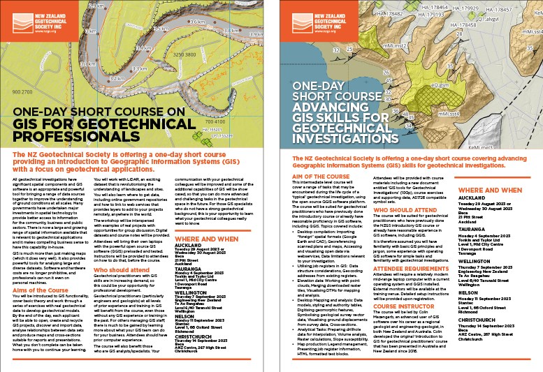
Since 2016, I have been running GIS courses for geotechnical practitioners, firstly in Australia in association with the Australian Geomechanics Society and later with NZGS. The initial impetus for creating these courses was to encourage the Tasmanian geotechnical community to incorporate spatial data being served by my then employer, the State Government, into their investigations and preferably using GIS software.
Fundamental to my initial- and subsequent courses, was the premise that GIS is more than just making maps! While maps are an important component of investigations, spatial data also allows pertinent geotechnical questions to be asked of it. For reasons of efficiency and technical expertise, it makes good sense that practitioners who have GIS ability to ask these questions throughout the course of an investigation.

ABOVE Photo of GIS course in Tauranga in September 2023.
Recently, at the invitation of the NZ Geotechnical Society, I presented 12 one-day courses through the country; Auckland (4), Tauranga (2), Wellington (2), Nelson (2), Christchurch (2) in late August-September 2023. I made a number of observations from these courses pertinent to the questions being asked, much of which applies to Australia as well:
- Education and Skill shortage. There is a shortage of GIS skills in engineering consultancies; not only in finding good GIS analysts/cartographers but also amongst the geotechnical practitioners themselves. In light of this, the recent news that Victoria University of Wellington is dropping GIS from its curriculum does seem somewhat ironic! While the reason given by VUW is due to low enrolments, I wonder why science students, particularly geologists, are not supporting this course? Perhaps this is something that NZGS needs to explore!
- Industry relevant training. Some attendees at my course are new to GIS while others have completed GIS modules at university and mostly in the same (proprietary) software being used by their employer. However, given the limited access these people have to proprietary software licenses they are somewhat frustrated and keen to learn alternative options such as QGIS. Given this, and following on from my previous bullet point, I wonder whether the GIS courses being offered at Tertiary institutions are sufficiently relevant to the geotechnical community? Furthermore, are they learning using the QGIS platform that is increasingly being used by geotechnical practitioners? Perhaps the success of the course I offer (as measured by attendance) partly answers this question.
- Using inappropriate tools. Without GIS skills and broader knowledge, many practitioners, in desperation, are undertaking their work in an inefficient and inappropriate manner exposing themselves to the risk of mislocating aspects of their investigation and adding cost to the client! This situation has obvious risks which is why industry-appropriate training in GIS is so necessary.
- Interoperability and internal support. Not all data formats used in various GIS platforms are able to be read commonly between them; an issue referred to as interoperability. However, interoperability problems can be overcome in an organisation if all GIS platforms and the users are adequately supported and there is good communication between parties. However, some geotechs I talked to using QGIS did not feel that sufficient support was being provided to them. This would seem to be a management problem with cultural-change aspects to it.
- Non-georeferenced plans. Surveyors and architects operating in the residential and subdivision market produce plans showing the location of proposed developments, such as building footprints and services. These plans ultimately are based on accurate survey measurements in the field. However, I am informed that these plans are being provided to geotechs in non-georeferenced formats such as paper prints, PDFs or even non-georeferenced CAD files. This practice makes it difficult for the geotech to locate where a building footprint exists on a site exposing them to the risk of getting it wrong as well as adding cost to the client. This is quite a puzzling situation as the original plan should be easily provided in a GIS compatible format! However, I have been told from people on my course that simply asking for a suitable format does not always provide a result. This is a problem that may benefit by involving their business manager discussing it with the client and the originators of the plan.
- Data discovery. Discovering where and how to access data from organisations can be challenging. Notable exceptions include LINZ who have a great website and are highly responsive to technical questions. Another source of information is a private company called Koordinates, that have created a platform to host data from multiple providers in NZ. However, while all local/regional government agencies have contemporary GIS systems, finding their web service addresses can be a mission! Furthermore, the contents of each map-server can be poorly documented and catalogued.
- Standardised mapping symbology. NZ is well served with classic geological mapping symbology, as provided by GNS Science, and it makes sense to use this styling in geotechnical reports where appropriate. However, there are several additional symbols required for engineering-geological mapping for which there is no ‘standard’ in the country. In Australia, the AS1726 Geotechnical Site Investigations document provides ‘suggested’ symbology’s for this type of mapping that pertain mostly to geomorphic features, and even these are certainly not complete. [The schema is also contained in Australian Geomechanics Landslide Risk Management Guidelines 2007 (LRM) which, unlike the standard, are free to download]. AS1726 was developed prior to modern GIS concepts and in my course, I provide symbols and data models that approximate the standard. My recommendation is that these symbols and data models be reviewed by NZGS with the aim of providing standard tools for the geotechnical community to use. [This is a process that looks likely to occur in Australia shortly as part of a proposed review of the LRM document discussed at the recent 2023 ANZ Cairns conference]. Furthermore, by properly defining the meaning of each symbol and using authority tables when creating such features in the GIS environment, it will promote consistency and aid communication and assessment.
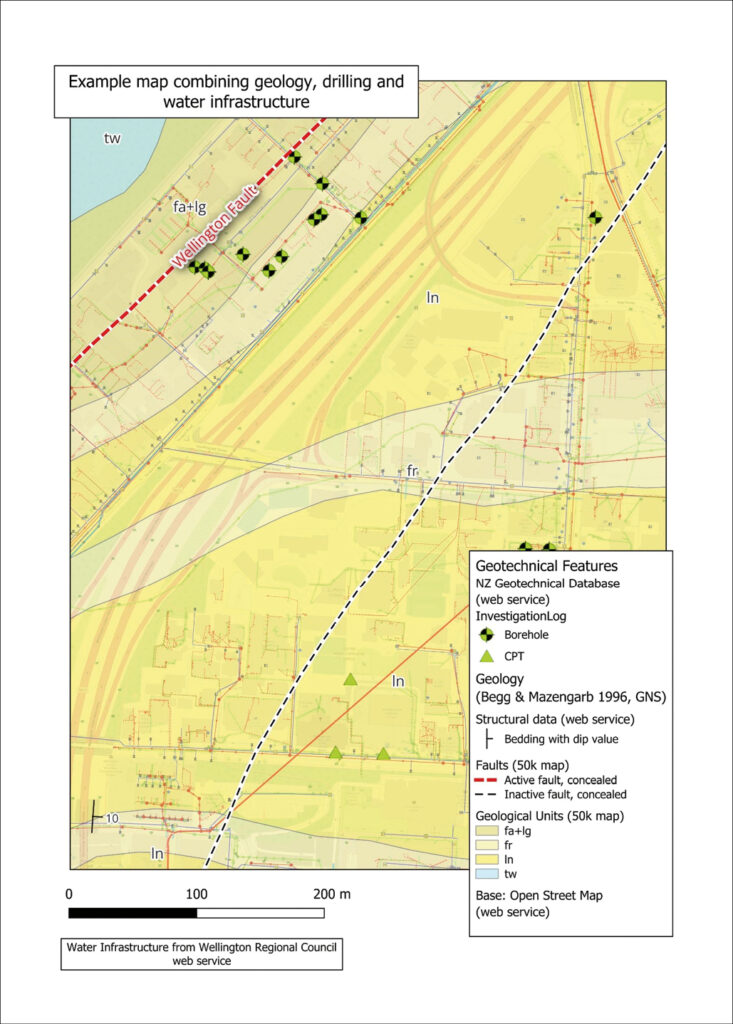
Figure 1 Example map.
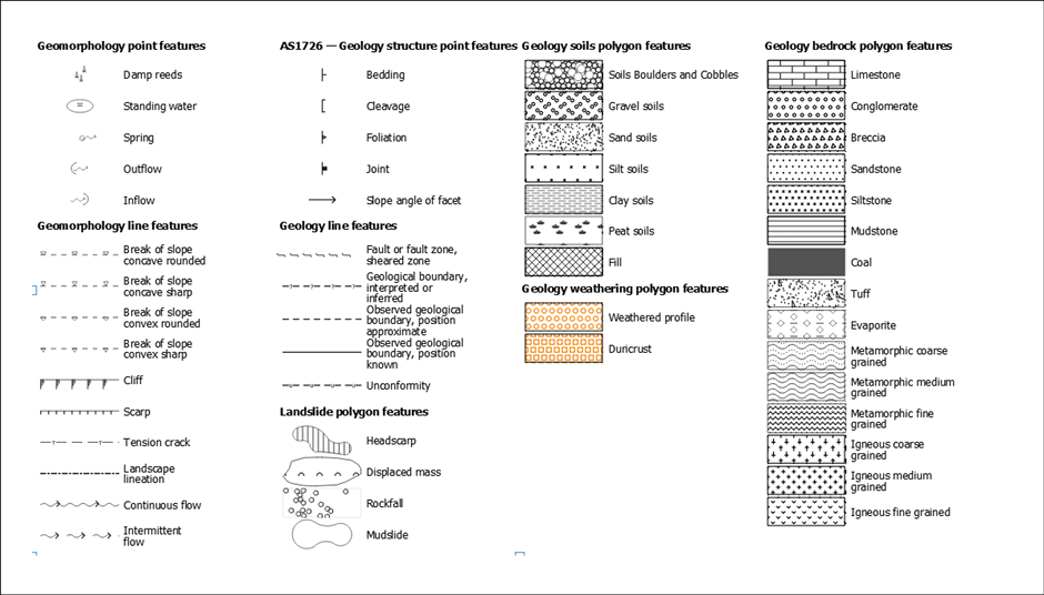
Figure 2 Mapping symbology from AS1726 Geotechnical Site Investigations
In conclusion, digital data at your fingertips is truly a technical reality in 2023 that many engineering companies are taking advantage of in their investigations. There is strong demand from engineering-geologists and engineers to learn how to incorporate this information into their workflow, but some impediments remain that need to be addressed as well as opportunities to be realised.
Finally, I would like to thank the New Zealand Geotechnical Society for inviting me to present my courses. A special thanks goes to Emilia (NZGS committee) and Teresa (NZGS Secretary) who did a fantastic job organising the logistics. Thanks also to BECA, Tonkin and Taylor Ltd, Engineering NZ and Stantec Ltd for providing excellent meeting facilities; the staff at each were extremely helpful. To those who attended my courses, it was a pleasure to work with you and I hope I have helped you in your journey learning how to use GIS.
Appendix:
Example web service URLs used to develop Figure 1
Wellington Water (Greater Wellington):
NZ Geotechnical Database: https://services2.arcgis.com/4xCbYRzn07xe64Sn/arcgis/rest/services/NewZealandGeotechnicalDatabase/FeatureServer
GNS: https://data.gns.cri.nz/server/rest/services/NZL_GNS_250K_Geology_2023/NZL_GNS_250K_geology_FeatureService_NZ/MapServer/13