
Analysis of Rockfall Fragmentation in the Torlesse Terrane Greywacke
Introduction
Rockfall is a highly complex process that poses a major hazard to exposed elements such as transport corridors, infrastructure, services, and people (Chau et al., 2003; Corominas et al., 2005; Giacomini et al., 2009; Hungr et al., 1999; Zhao et al., 2017)2009; Hungr et al., 1999; Zhao et al., 2017. The fragmentation of blocks is a key process that occurs during rockfall and can significantly alter the travel mechanisms (bouncing, rolling, and sliding), trajectory, and runout distance (Ruiz-Carulla et al., 2015). Despite being an important factor in rockfall, there remains a limited understanding of the factors that control the fragmentation of rockfall blocks. As a result, fragmentation is rarely included in rockfall modelling, which may be causing an under- or over-design of risk-based rockfall remediation.
Numerous studies have been conducted that investigate how different rockfall conditions and rock mass characteristics control fragmentation behaviour of rockfall blocks. However, fragmentation remains poorly understood (Giacomini et al., 2009; Gili et al., 2022; Gili Ripoll et al., 2016; Matas, Lantada, Corominas, Gili, et al., 2020; Matas, Lantada, Corominas, Ruiz Carulla, et al., 2020, 2020; Ruiz-Carulla, 2018; Ruiz-Carulla et al., 2015, 2018, 2020).
This paper provides a summary of the thesis submitted to the University of Canterbury (Dow, 2023) which investigates rockfall fragmentation on greywacke sandstone sourced from three sites across the South Island of New Zealand. Greywacke is a dominant basement rock which accounts for 20% of the bedrock in New Zealand with the majority of it found in the South Island (Brideau et al., 2022).
Rockfall is well documented to occur in New Zealand, particularly in the extensive mountainous greywacke terranes and along coastal regions. In 2010, 2011, and 2016 three major earthquakes triggered significant rockfalls and landslides in the Canterbury region.
The worst was experienced during the 2016 Mw 7.8 Kaikōura earthquake which resulted in over 40 major landslides and extensive rockfall that cut off 28 km of the national transport corridor, State Highway 1 (SH1) and KiwiRail’s Main North Line (MNL), north and south of the Kaikōura (Green et al., 2018).
Methodology
Three field sites were selected located in Kaikōura (Site A), Arthurs Pass (Site B), and Tekapo (Site C) (Figure 1). Each site is geologically situated within sandstone greywacke of the Torlesse Superterrane and was geotechnically characterised through field observations and measurements. This included measuring discontinuity spacing, persistence, aperture, roughness, orientation, estimated block volume, and uniaxial compressive strength (derived from L-Type Schmidt hammer rebound numbers). In situ rock samples were collected from each site (20 per site – 60 in total). The samples collected ranged from 6.1 kg to 76.5 kg and typically comprised slightly weathered greywacke sandstone.

Figure 1. South Island basement rock metamorphic zonation. Terrane zones ignore more recent overlying sedimentary and volcanic rocks. Red dots = approximate field site locations, z = zeolite facies; pp = prehnite-pumpellyite facies; pa = pumpellyite actinolite facies. Figure modified from Landis and Bishop (1972), terrane extents from Cooper and Ireland (2015), and tectonic uplift rates and major fault traces from Williams (1991).
A 3D photogrammetric model of each sample was created, and the discontinuities mapped using LeapFrog software (Figure 2). From the LeapFrog model, highly detailed rock mass characteristics of each sample were derived. These rock mass characteristics included the number of fractures, fracture density, fracture intensity, fracture persistence, and pre-test modelled fragment size distribution. The pre-test modelled fragment size distribution was derived from the major discontinuities mapped on the sample that intersect or terminate with other major discontinuities and/or the outside of the sample to form a block. For the purpose of analysis, any blocks smaller than 1e-7 m3 were removed from the data set as they are smaller than the scale of discontinuity mapping and give skewed results.

Figure 2. LeapFrog model of Sample 10 from Arthurs Pass showing the minor1 (white lines) and major1 (red lines) discontinuities and the inferred discontinuity planes mapped on the sample. Scale is in metres.
1 Major fractures are defined by fractures that either intersect with other major fractures, or the outside of the sample, to form blocks within the sample. Minor fractures are defined by fractures that did not appear to intersect with other fractures, or the outside of the sample, to form blocks within the sample.
Subsequently, real-scale rockfall fragmentation testing was undertaken to explore the fragmentation process and compare findings with the pre-test data. The real-scale rockfall fragmentation testing methodology used in this study is an adaption of that used in Giacomini et al., (2009), Gili Ripoll et al., (2016), and Ruiz-Carulla et al. (2020). Samples were dropped from a single benched quarry with a vertical height of 16 m. A rock dropper apparatus (Figure 3) was used to release the samples from a consistent height while allowing them to freefall before impact. Samples that did not fragment upon the first impact were redropped to investigate the influence that multiple impacts have on fragmentation behaviour. A total of 59 samples were tested with 80 drops in total (59 initial drops and 21 redrops).
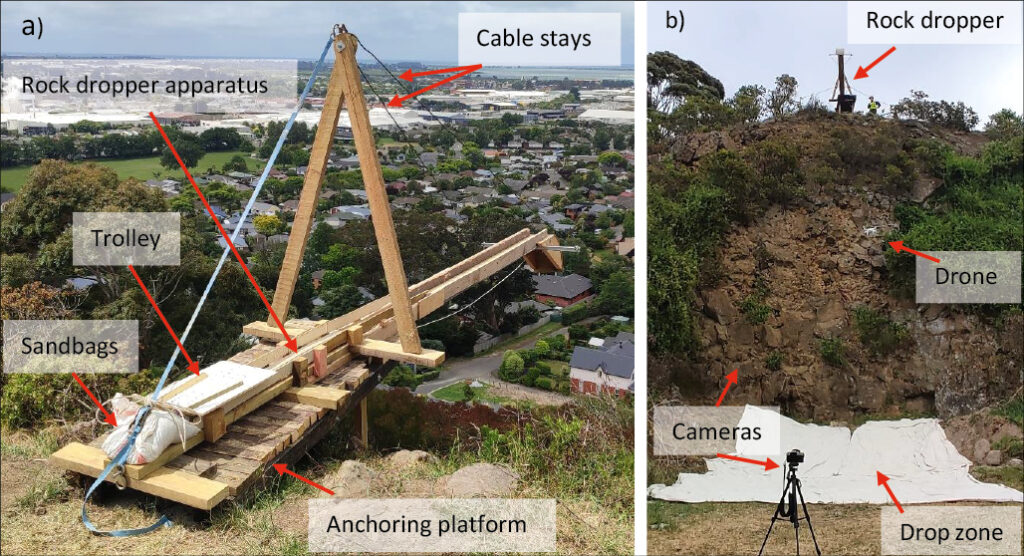
Figure 3. a) rock dropper apparatus attached to anchoring platform at the top of the quarry bench. b) Drop zone setup at the base of the quarry used for the fragmentation testing.
Key findings and conclusions
Between the three field sites, the fragmentation rates were highly variable. Site B produced the highest number of fragments per sample (28.75), followed by Site A (20), and Site C (6.75). The percentage of samples that fragmented was also variable between each site, ranging from 90% at Site B to 35% at Site C. From the initial 59 samples that were dropped, 38 (64%) fragmented on the first impact. The 21 blocks that remained intact were subsequently redropped of which nine (43%) fragmented. The number of fragments measured after each drop ranged from one (no fragmentation) to 175. The pre-test modelled fragment size distributions were able to correctly model the relative number of fragments produced during simulated rockfall, however, the size of the largest fragments (>0.01 m3) and frequency of the smallest fragments (0.0001 m3) were underestimated, while the frequency of moderately sized fragments (0.0001-4 m3 to 0.01-2 m3) were overestimated (Figure 4).

Figure 4. Modelled and measured combined block size distributions from Site A, B, and C samples.
Fragmentation was found to be weakly correlated with the Geologic Strength Index (GSI), fracture density, and block size. GSI may be able to provide a rough indicator of the relative amount of fragmentation that may occur between different sites, however, it is likely too generalised to be able to accurately predict absolute fragmentation rates. Fracture density is more strongly correlated with the largest fragment size, with greater fracture densities yielding smaller maximum fragment sizes (Figure 5). Additionally, the sample volume was found to be relative to the largest fragment such that larger sample volumes produced greater maximum fragment sizes as would be expected.
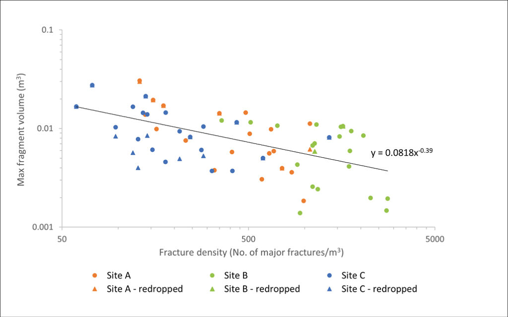
Figure 5. Maximum fragment volume against fracture density.
The runout and spread of rockfall blocks that fragmented was significantly greater than blocks that remained intact with fragmented blocks having, on average, a 2.14 m further runout distance and a 231% greater coverage. This highlights that fragmentation can result in an increased hazard footprint for rockfall and therefore should be incorporated into hazard and risk assessments.
Overall, the findings from this study suggest that fragmentation is primarily controlled by the discontinuities within the rock mass and the initial block size. Other rock mass characteristics investigated did not show strong relationships with fragmentation behaviour, however, this does not mean they do not have an influence on it. Instead, it suggests that some factors influence fragmentation to a larger degree than others. Additionally, this study showed that the runout and spread of fragmented rockfall deposits are greater than that of blocks that did not fragment (when impacting a near horizontal surface).
A summary of the main conclusions from this study are listed below:
- Despite all sites having similar lithology, weathering, and large-scale structure, the fragmental behaviour was highly variable. This suggests that a single lithology can behave variably, and site-specific investigations need to be carried out to fully characterise the rock mass.
- Although the geological and climatic history is key in controlling the formation of the rock mass at each site, no clear direct relationship was found between these and fragmentation behaviour. The geologic and climatic history is too large of scale for site specific fragmentation analysis and a more detailed level of data is required for a better understanding of why blocks fragmented the way they do.
- The UCS of the intact rock, derived from L-type Schmidt hammer rebound numbers, does not appear to be correlated with fragmentation behaviour. However, the UCS likely does have some influence on fragmentation behaviour, but it is difficult to determine due to the many other variables which play a larger role in the fragmentation process.
- Major discontinuities are a significant factor that control fragmentation behaviour and can be used, in part, to model the number and size of fragments expected after impact. Combining the use of GSI and discontinuity mapping when characterising rock masses may provide a better estimate at fragmentation behaviour. It was found that Site C, with a higher GSI value (65 – 70), rockfall fragmentation behaviour could be modelled with relatively high accuracy using major discontinuities alone. The other two sites, which had lower GSI values (45 – 60 and 45 – 65), were unable to be modelled as accurately. This suggests that GSI may be able to give an indication as to the amount that major fractures influence fragmentation, however, further research needs to be conducted to better understand this relationship. No correlation was found between sample shape/sphericity and fragmentation behaviour. The volume of the sample, on the other hand, proved to be roughly relative to the largest fragment generated where the larger the initial volume, the larger the largest resultant fragment will be.
- A second impact was observed to cause samples to fragment that did not fragment during the first drop. This indicates that successive impacts may increase a rock block’s chance of fragmentation and that blocks may fragment continuously as they travel down slope. However, >50% of those samples that were redropped remained intact after the second drop, suggesting that some samples may be impervious to fragmentation irrespective of the number of impacts they experience.
- The runout and spread of rockfall blocks is increased by fragmentation when impacting a relatively flat surface. Bounce height was also observed to be increased due to fly rock being produced, however, no direct measurements were taken to show this, and further analysis of video recordings of each drop needs to be undertaken to confirm this observation.
- Overall, no single rock mass characteristic can be used to predict how a block will fragment, rather a combination of factors need to be considered when attempting to model fragmentation. Further works are required to better understand the magnitude that different rock mass characteristics and rockfall conditions control fragmentation behaviour.
References
Brideau, M.-A., Massey, C. I., Carey, J. M., & Lyndsell, B. (2022). Geomechanical characterisation of discontinuous greywacke from the Wellington region based on laboratory testing. New Zealand Journal of Geology and Geophysics, 65(2), 265–282. https://doi.org/10.1080/00288306.2020.1853181
Chau, K. T., Wong, R. H. C., Liu, J., & Lee, C. F. (2003). Rockfall hazard analysis for Hong Kong based on rockfall inventory. Rock Mechanics and Rock Engineering, 36(5), 383–408.
Cooper, A. F., & Ireland, T. R. (2015). The Pounamu terrane, a new Cretaceous exotic terrane within the Alpine Schist, New Zealand; tectonically emplaced, deformed and metamorphosed during collision of the LIP Hikurangi Plateau with Zealandia. Gondwana Research, 27(3), 1255–1269. https://doi.org/10.1016/j.gr.2013.11.011
Corominas, J., Copons, R., Moya, J., Vilaplana, J. M., Altimir, J., & Amigó, J. (2005). Quantitative assessment of the residual risk in a rockfall protected area. Landslides, 2(4), 343–357.
Dow, D. (2023). Analysis of Rockfall Fragmentation in the Torlesse Terrane Greywacke [University of Canterbury]. https://ir.canterbury.ac.nz/server/api/core/bitstreams/e8b70447-d356-4f85-81ff-27a97406f354/content
Giacomini, A., Buzzi, O., Renard, B., & Giani, G. P. (2009). Experimental studies on fragmentation of rock falls on impact with rock surfaces. International Journal of Rock Mechanics and Mining Sciences, 46(4), 708–715.
Gili, J. A., Ruiz-Carulla, R., Matas, G., Moya, J., Prades, A., Corominas, J., Lantada, N., Núñez-Andrés, M. A., Buill, F., Puig, C., Martínez-Bofill, J., Saló, L., & Mavrouli, O. (2022). Rockfalls: Analysis of the block fragmentation through field experiments. Landslides. https://doi.org/10.1007/s10346-021-01837-9
Gili Ripoll, J. A., Ruiz Carulla, R., Matas Casado, G., Corominas Dulcet, J., Lantada, N., Núñez Andrés, M. A., Mavrouli, O. C., Buill Pozuelo, F., Moya Sánchez, J., & Prades Valls, A. (2016). Experimental study on rockfall fragmentation: In situ test design and first results. 983–990.
Green, R., Lambert, C., Watts, C., Kennett, D., & Ryder, E. (2018). Development and testing of a modular rockfall protection wall to mitigate earthquake-induced slope hazards. 69th Highway Geology Symposium, Highway Geology Symposium.
Hungr, O., Evans, S. G., & Hazzard, J. (1999). Magnitude and frequency of rock falls and rock slides along the main transportation corridors of southwestern British Columbia. Canadian Geotechnical Journal, 36(2), 224–238.
Landis, C. A., & Bishop, D. G. (1972). Plate Tectonics and Regional Stratigraphic-Metamorphic Relations in the Southern Part of the New Zealand Geosyncline. GSA Bulletin, 83(8), 2267–2284. https://doi.org/10.1130/0016-7606(1972)83[2267:Ptarsr]2.0.Co;2
Matas, G., Lantada, N., Corominas, J., Gili, J., Ruiz-Carulla, R., & Prades, A. (2020). Simulation of Full-Scale Rockfall Tests with a Fragmentation Model. Geosciences (Basel), 10(5), 168. https://doi.org/10.3390/geosciences10050168
Matas, G., Lantada, N., Corominas, J., Ruiz Carulla, R., Prades, A., & Gili, J. (2020). Calibration of a rockfall simulator with a fragmentation model in a real-scale test.
Ruiz-Carulla, R. (2018). Rockfall analysis: Failure, fragmentation and propagation characterization: A fractal fragmentation of rockfalls.
Ruiz-Carulla, R., Corominas, J., Gili, J. A., Matas, G., Lantada, N., Moya, J., Prades, A., Núñez-Andrés, M. A., Buill, F., & Puig, C. (2020). Analysis of Fragmentation of Rock Blocks from Real-Scale Tests. Geosciences, 10(8), 308.
Ruiz-Carulla, R., Corominas, J., & Mavrouli, O. (2015). A methodology to obtain the block size distribution of fragmental rockfall deposits. Landslides, 12(4), 815–825. https://doi.org/10.1007/s10346-015-0600-7
Ruiz-Carulla, R., Corominas, J., & Mavrouli, O. (2018). Comparison of block size distribution in rockfalls. In Landslides and engineered slopes. Experience, theory and practice (pp. 1767–1774). CRC Press.
Williams, P. W. (1991). Tectonic geomorphology, uplift rates and geomorphic response in New Zealand. CATENA, 18(5), 439–452. https://doi.org/10.1016/0341-8162(91)90048-3
Zhao, T., Crosta, G. B., Utili, S., & De Blasio, F. V. (2017). Investigation of rock fragmentation during rockfalls and rock avalanches via 3-D discrete element analyses. Journal of Geophysical Research: Earth Surface, 122(3), 678–695. https://doi.org/10.1002/2016JF004060

