Current and future geological hazard resilience in the Porirua City Council region.
K.E. Jones, G.A. Cassidy & G.R. Crisp
ENGEO, Wellington.
F. Fleming, K. Cushing
41 South, Wellington.
D. Statham
Porirua City Council, Wellington.
ABSTRACT
Widespread slope instability occurred in the Porirua region after the significant storm event on 15 November 2016 and continued for a number of days. Emergency risk assessments and subsequent mitigation works were undertaken on behalf of Porirua City Council (PCC) with an initial focus on life safety then maintaining safe road access to suburban areas of Porirua. PCC did not have an existing emergency response strategy or procedure for such large scale events and the overall response was somewhat disjointed, improvised and labour intensive.
After the emergency period had abated, 41South presented a workshop to PCC to assist them to improve their systems and procedures should a similar emergency occur in future. ENGEO also presented how a slope stability rating system could be used to prioritise future response and shortcomings of such a system in this context.
In this paper we will discuss the processes undertaken, the involvement of ENGEO and 41South in the emergency response process, and the geological environment, including specific examples of slope geometry and local soil/rock conditions that were found to be prone to failure. The paper will provide a series of technical and procedural recommendations concluding with a suggested Geo-Hazard Preparedness & Continuity Plan (GPCP).
ENGEO have since been engaged by PCC as Geohazard subject matter experts to undertake regulatory reviews for new consent applications in the Region. Forming part of a Council led internal improvement exercise, this will aid future resilience for geotechnical structures in subdivisions and structures constructed within the Porirua region.
The event
Earthquake and Storm Event
While still dealing with the effects of the 14th November 2016 Mw7.8 Kaikoura earthquake, the Wellington region was hit by heavy rainfall the next day that caused flooding in a number of areas. Slips and surface flooding resulted in a number of road closures including three main state highways (SH1, SH2, SH58) and also Paekakariki Hill Rd and Grays Rd in Porirua.
Greater Wellington Regional Council rainfall monitoring sites measured up to 80mm of rainfall in just six hours around the Porirua and Pauatahanui areas. High river flows were recorded with the Pauatahanui Stream in the Porirua district reaching a level with an estimated 1 in 20-year return period (GWRC 2017). In comparison, the rainfall gauge at Battle Hill in the Porirua district received 60mm of rainfall in the entire month of November the previous year (GWRC 2015).
Effect of these natural events on the slopes of Porirua
The combination of earthquake and storm resulted in approximately 60 landslides occurring in the Porirua Region at the locations shown in Figure 1. The landslides are concentrated in areas most recently developed where cut and fill slopes are prevalent.

Figure 1: Locations of Slips
Geology and geomorphology of slopes in the Porirua region
Geology
The geology of the Porirua Region (Begg & Johnston 2000), generally comprises Holocene undifferentiated weathered, poorly sorted loess-covered alluvial gravel deposits or loess overlying Rakaia Terrane comprising grey sandstone and mudstone sequences and poorly bedded Sandstone, commonly known as Wellington Greywacke. Colluvium is also apparent on and at the base of slopes.
Geomorphology
Based on site measurements, slope angles of the failed soil slopes were between 40° and 80° with an average of 50°. Natural soil slopes in the area are typically stable (static case) at approximately 20° to 40°. 74% of the failed slopes we assessed were slopes that had been modified by cuts during historical development. The most common failure mechanism of these cut slopes was failure in the silty loess and/or colluvial soil which we infer had been cut at too steep an angle to provide long term stability. The other 26% of failures appear to have occurred either due to increased stormwater flow down gullies causing erosion (occasionally compounded by insufficient capacities of culverts at the base of the gullies), undercutting of slopes adjacent to streams and failure of fill downslope due to increased pore water pressure within the soil mass. The shaking caused by the Kaikoura earthquake the previous day may have contributed to the instability in the region by loosening of the soil and weathered rock, however this is impossible to quantify.
Emergency response
In the immediate hours and days after the events, PCC was inundated with calls and reports of slips and many other associated effects such as overflowing stormwater systems and broken assets. In the first 48 hours a team was organised to try and collate these events to understand the magnitude of works and prioritise the response. Calls were logged into a spreadsheet from various avenues including front desk calls, reports from officers, reports from emergency services and observations by staff on site.
Several months before, 41South (41S) had successfully completed the project management and construction of a one-off retaining wall on behalf of PCC. In the days after the earthquake and storm event, 41S contacted all major clients to offer assistance. PCC requested that staff from 41S work in PCC offices for two weeks initially to get a better understanding of the scale and complexity of the situation and the inputs required.
The first step was to uplift the spreadsheet of events and work out duplicate reports – many sites were reported more than once with different descriptions for example, outside number X, opposite the driveway of house X, next to the lamp post, 100m from x, etc. The system was an immediate reaction to an unexpected event and there was no specific structure to the response. “The PCC team were making it up as they went along” (Fraser Fleming, 2020).
As resources were limited, ENGEO were engaged to undertake initial geological risk assessments on each landslide that had been prioritised. Approximately 60 initial site visits were undertaken and the team worked with PCC maintenance contractors (Downer) to manage the sites from a traffic and pedestrian management and health and safety aspect.
Slope risk assessment and remediation
ENGEO were engaged to undertake initial risk assessments on each site that had been prioritised. The reports were used by PCC to further develop the list of prioritised works. Nine sites were assessed within the first three days of the large rainfall event on 15 November 2016. Another 27 slopes were assessed in November and a further 12 slopes before the end of 2016. The sites were visited in the approximate order of the PCC request. When a large number of sites were requested at one time, the sites were sorted based on location with the aim of assessing as many as possible in the most efficient order.
For each site a walkover was conducted, photographs taken and the landslide features measured and recorded. Key measurements made were the dimensions of the head scarp, the extent of debris and the distances between the hazard and assets such as PCC roads and private property. Also noted was any evidence of continuing or future failure such as angle of the debris slide or slope and size of any tension cracks observed in the area. Preliminary assessment regarding the level of risk were discussed onsite and these were assessed in more detail during the reporting stage. It was crucial to have a minimum of two experienced geologists/geotechnical engineers undertake each assessment both for health and safety reasons (as often the sites involved climbing up/down steep slopes) and to be able to have informed onsite discussions about potential failure mechanisms, the risks of ongoing instability and to distinguish risk factors between sites in order to assess the sites most at risk.
An initial assessment report was completed for each site. The report outlined the location, description of hazard and interpretation of the cause(s) of the hazard. The initial inspection reports also assessed the risk of the site using a qualitative Risk Matrix Template that was adapted for this purpose. This matrix assesses the risk based on the likelihood of potential reoccurrence events and the consequences that these events could have to PCC and private assets, such as roads, existing retaining walls and houses. If the site was assessed to have a risk higher than ‘low’ then the report also included recommendations for immediate and long term remedial and mitigation actions. In most cases multiple long term options were provided along with approximate design and construction costs for each option. Examples of long term mitigation options provided across various sites included debris catch fences, permanent slope regrading and replanting, rock anchored retaining walls and cantilevered timber retaining walls.
A ranking system was developed based on the severity of the landslide, the damage, the risk to the public, the risk to private property, the risk to PCC assets, etc. The sites were ranked Red, Orange Yellow and Green:
- Red – Sites where the risk was required to be reduced immediately. These slopes had an immediate impact on people, whether compromising a property or major road.
- Orange – Sites where mitigation was required as soon as possible but with less priority than the red slopes. These slopes posed no immediate threat to public, however were at danger of doing so with future seismic or rainfall events.
- Yellow – Sites where monitoring was required with potential for mitigation to be needed if further failure could impact the public. These slopes are likely to fail again, however these posed no current danger to the public.
- Green – Sites where monitoring only was required. The cost of applying mitigation measures to these slopes would outweigh the benefits gained.
This new system was debated with ENGEO, Downer, PCC staff including the PCC communications team, the PCC call centre manager and 41S to develop a ranked set of sites that needed immediate attention. During these meetings the preferred mitigation solutions were chosen for the sites classified into the Red category and the investigation and design for these solutions started. Mitigation designs were generally undertaken by ENGEO in conjunction with inputs from specialist contractors where necessary. 41S was engaged to manage the programme of works and has been involved from November 2016 to the current date.
Construction was completed by a number of local, trusted contractors known to have the correct equipment and skills for specific solutions. In the initial stages, the construction of retaining solutions of critical sites were awarded based on availability of resource. As the workload reduced, competitive tendering was used to evaluate tenders. In some instances parallel pricing was also used to ensure competitive prices were provided to PCC.
Throughout the initial three to six months, additional reports of new sites were added to the list as new events occurred over time. There were periods of heavy prolonged rain throughout the following winter that worsened existing landslides and added new sites to the list which required constant updating and regular reprioritisation meetings.
The workload reduced to a point where ‘Business as Usual (BAU)’ is considered to have been reached by mid-2019.
Examples of Red classified Sites
Three sites that were Red classified were Ivey Bay Reserve (Figures 2 and 3) Motuhara Road (Figure 4 and 5) and Moonshine Road (Figures 6 and 7).
Ivey Bay Reserve
Ivey Bay Reserve was one of the first landslides inspected due to the extent of the damage to private property. The land slipped from the back garden of a property down into Ivey Bay Reserve, which is a public walking area. The scarp of this slide was five metres high with the crest of the landslide only four metres laterally from the house. It was assessed that the landslide mostly occurred in fill material and failure was triggered by the saturation of this material. This slip was Red classified due to the potential for future damage to both the property and the PCC managed Ivey Bay Reserve. Permanent remediation measures recommended for this landslide were an anchored steel post retaining wall, an anchored shotcrete wall or an anchored steel mesh wall.


Figures 2 and 3: Ivey Bay Reserve Slip
As all of the potential remedial options required solutions on the private property, it was considered that the property owners and their insurers would cover the majority of the remediation work costs.
Motuhara Road
On Motuhara Road were two adjacent landslides that extended from the footpath to the properties above down to Motuhara Road below. Both slip areas were approximately eight metres wide and five metres high. These slips had caused the footpath to these two properties to be undermined by up to 0.75 m. Due to the possibility for restricted access to these private properties and debris falling onto the blind corner on the road below, these slip areas were assessed to be in the Red response category. It was assessed that the area between the two slip areas that did not fail in November 2016 was also at risk of future failure and it was therefore recommended that a remedial solution was applied to the entire unstable section of approximately 80 m in length. The remedial solution recommend for this site was an anchored shotcrete wall.
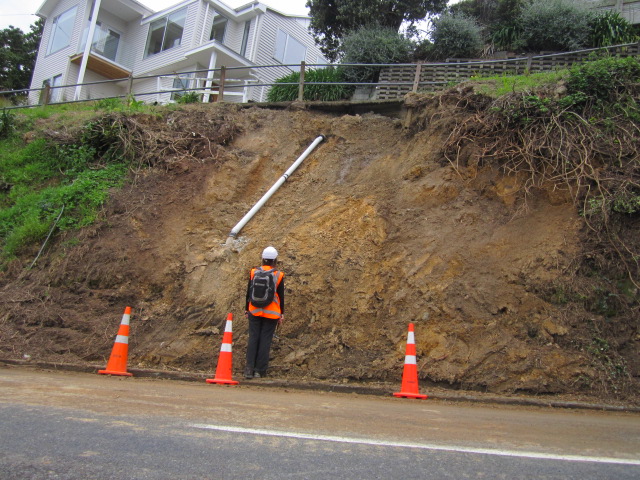

Figures 4 and 5: Motuhara Road Slip before and after remediation
As this landslide was entirely located on PCC land and the need for remediation was deemed urgent, ENGEO were engaged to proceed with the investigation and design for this solution. In February 2017 an investigation was undertaken on the site to confirm the ground conditions and depth to rock. ENGEO then designed an anchored shotcrete wall which was issued to PCC in March 2017. The construction of this project commenced in June 2017 and was practically completed by November 2017.
Moonshine Road
There were several roads where more than one landslide was observed and these roads were classified as one site. These roads included Airlie Road, Kenepuru Drive, Moonshine Road and Paekakariki Hill Road. These roads were able to be classified as one site due to the remote location of the roads and distance from private properties. Motuhara Road for example also had several landslides reported, however as these landslides affected several different private properties as well as the private road it made sense to treat them all as separate sites.
On Moonshine Road there were four significant sites identified during the initial assessment after the November 2016 event (Figures 6 and 7). At each of these sites the Pauatahanui Stream, which runs alongside Moonshine Road to the west, had eroded the inside corner of the road, leading to the undercutting of the road. During the storm event the stream reached 1 in 20 year peak levels (GWRC 2017). The shoulder of the road had failed at all four sites, with the head scarps just outside of the edge of the lane. Slip area one was the largest, extending to approximately 35 m in length. Three out of the four slip sites had existing large concrete blocks used as bank retaining that had been displaced by the stream during the failure event. The overall level of importance of the road was Orange classified, due mostly to the remote location of the road. Remediation measures suggested for these slip areas were a combination of gabion basket or steel post retaining walls.
Moonshine Road continued to be monitored throughout the 2016/2017 summer period and after additional monitoring the response category for this road was increased to Red. Other areas along the road were also identified to be at risk after further rainfall events. Investigations were undertaken on the various sites along Moonshine Road in March and May 2017. A test pile was also installed to inform the preferable type of wall. After the test pile and investigations, six gabion walls and one steel and timber post wall were designed. The design and construction for all of these walls was completed by the end of 2017.

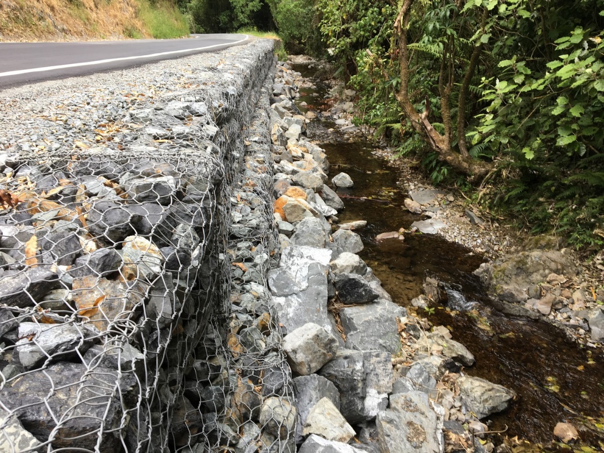
Figures 6 and 7: Moonshine Road Slip area before and after remediation
Learnings and outcomes
Geo-Hazard Preparedness & Continuity Plan
Figure 8 details a process improvement plan issued to PCC in June 2018. This plan was intended to be a one page reminder of the major steps. The more in depth details are documented on the PCC filing system and include key elements listed below. The plan was developed throughout the slips management process and was discussed and prepared in conjunction with PCC officers, geotechnical engineers, contractors (where necessary) and after taking legal and consenting advice.

Figure 8: Geo-Hazard Preparedness & Continuity Plan (GPCP)
The key elements the improvement plan from which the GPCP was derived are:
- Definitions of roles and responsibilities
- How initial contact should be managed
- Declaration of a State of Emergency
- An initial site visit – who should attend and their role on site
- The first 24 hours plan
- Internal meetings to discuss the way forward
- Days 2 to 5 management plans
- How to manage investigations
- The design phase
- The construction phase
- Council Insurance and Legal Processes
- Document Management
- Health and Safety
- The role of New Zealand Transport Agency (NZTA)
- Communication;
- Potential Stakeholders
- A small scale evacuation process
- Project close-out
Throughout each of the stages, the instructions cover communications, funding, consenting and document management (including a suggested filing structure under PCC Daisy file management system).
Monitoring Slope Performance
The following monitoring options have been suggested to PCC to assess the performance of existing unretained and retained slopes.
Slope Stability Rating
The qualitative risk assessment of existing slope stability is a well-known and commonly used method of simply assessing the stability of slopes along linear infrastructure such as roads and railways. Key benefits of this method are that it is relatively quick to assess large volumes of slips in a time efficient manner. However, the authors believe that one drawback of this method of risk assessment lies with the simplistic way the data is collected and risks are assessed, making important decisions around site prioritisation, for example, somewhat challenging when dealing with a significant number of slopes in a short space of time.
ENGEO have discussed the merits of adopting a quantitative risk assessment tool; specifically to serve as a benchmark of all unretained slopes in the Porirua region. Having such a system in place would mean that key high risk areas can be prioritised for future capital works budgets and also would serve as a ‘first check’ immediately after a seismic or significant storm event. Such quantitative systems exist around the world including the Roads and Maritime Services (RMS) system in Australia and also the KiwiRail Slope Rating System (Justice & Cassidy 2012) here in New Zealand, however additional complexities exist within the Territorial Authority landscape including making such risk rating information available to the public and what the possible effects of this may be. For example, if a slope above a PCC road has a high risk rating then would the homeowner above be negatively affected by this information should they wish to sell their home? PCC are currently considering their options in this regard.
Existing retaining wall assessments
Many retaining walls in PCC reserve land have either been under-designed or have reached the end of their design life. As a result, there are a number of walls exhibiting stress / damage, for example rotation, corrosion and loss of backfill. Based on our preliminary assessments for a number of walls, the primary contributing factor to poor performance is inadequate or non-existent drainage.
ENGEO has provided assessments of this infrastructure, where damage has occurred, in the form of the qualitative assessment using the Risk Matrix Template.
They have since provided a simple assessment framework and training to the PCC maintenance team such that they can assess existing walls and determine whether or not they require an engineer’s assessment.
They have discussed the merits of a district wide qualitative assessment for retaining infrastructure such that PCC would be able to prioritise repair or replacement. A system such as this would allow PCC to refine maintenance budgets and allocate funding in advance. We have suggested this should be a modification to the slope rating assessment system, such that each wall would have a rating allowing PCC to prioritise maintenance, repair or replacement accordingly.
Regulatory reviews
In the past, PCC have not relied upon review of geotechnical practices on subdivision projects by external consultants, apart from occasional peer reviews, as these applications have been reviewed by PCC planners. Since the 2016 events, PCC have committed to raising the bar on geo-hazard risk avoidance by engaging geotechnical input at both resource consent, building consent and earthworks completion stages of projects. This is to be completed using a panel of geotechnical experts from various consulting companies in the Wellington Region. The regulatory reviews are intended to be an over-arching review of the proposed works from a geotechnical perspective, focusing on whether the applicant has considered all the necessary risks associated with the development. This is not intended to be a detailed technical peer review – although, such peer reviews may be requested from time to time as found to be specifically required.
Conclusions
Approximately 60 landslides resulted from the heavy rainfall event in the Porirua region on 15th November 2016. The majority of these slips occurred due to over-steep cuts in loess or colluvial soil during the historical modification of slopes for residential development.
PCC had no plan in place for managing such an occurrence and in the immediate hours and days after the event, PCC was inundated with calls and reports of slips and many other associated effects such as overflowing stormwater systems and broken assets. A plan was required to manage all of the data and prioritise sites for assessment and remediation. 41S and ENGEO were engaged by PCC to manage the assessment, prioritisation and remediation of the slopes using a ranking system based on the severity of the slip, the damage, the risk to the public, the risk to private property, the risk to PCC assets, etc.
This system has been described, and suggestions provided on how PCC could manage this process if such an event were to occur again in the future, as well as programmes to monitor and assess existing assets on a BAU basis. These systems could be applied to other regions of New Zealand and globally.
References
Begg, J.G. & Johnston, M.R. (compilers) 2000. Geology of the Wellington Area. Institute of Geological & Nuclear Sciences 1:250,000 geological map 10. 1 sheet + 64p. Lower Hutt, New Zealand.
Greater Wellington Regional Council, Climate and Water Resources Summary for the Wellington Region Spring 2015 Release date: December 2015.
Greater Wellington Regional Council, Climate and Water Resources Summary for the Wellington Region Warm Season (November to April) 2016/2017 Release date: 25 May 2017.
Justice, T.R. & Cassidy, G.A. 2012. Proceedings of the ANZ Geomechanics Conference, Melbourne, Australia.