Advances in NZ Research
Research into Seismic Design and Performance
of High Cut Slopes in New Zealand
Introduction and background
Transportation routes are critical lifelines for the community, particularly in the event of natural hazards. New Zealand has a rugged terrain and high seismicity, which means that high cut slopes are required to form transportation routes. The performance of these slopes in earthquakes is critical to ensure a resilient transportation system. Although the focus of the research was on transport routes, the outcomes will also inform the assessment or design of steep slopes that affect the vulnerability and life safety associated with buildings and other facilities adjacent to steep slopes.
Currently there is very little guidance available for the earthquake design of high cut slopes either in New Zealand or internationally. The potential for topographical amplification of earthquake shaking, and the observation of the large landslides that have affected transportation routes in earthquake events has raised the awareness of the need for research and development of guidelines for the seismic design of high cut slopes. The New Zealand Transport Agency engaged Opus International Consultants to carry out this research and development of guidance.
Research Team
This research has been carried out by Messrs P Brabhaharan, Doug Mason, Eleni Gkeli and Andy Tai of Opus International Consultants, and Graham Hancox from GNS Science, and assisted by other staff from both organisations. Graham Hancox focussed on the landsliding in past earthquakes in New Zealand. The contribution of the peer reviewers, Prof George Bouckovalas, and Dr Trevor Matuschka is gratefully acknowledged. The contribution of Prof Nick Sitar is also gratefully acknowledged.
Research Scope and Objectives
The research included:
1. Review of the performance of high cut slopes in recent worldwide earthquakes
2. Consideration of the influences of the distinctive aspects of New Zealand’s seismicity and topography,
3. Review of relevant recent research on topographical effects from New Zealand and overseas
4. Review of current design practice in New Zealand and overseas
5. Development of guidelines for the earthquake
design of high cut slopes in New Zealand.
Some limited targeted numerical modelling has been carried out as part of this research to test the topographical effects and variation of seismic shaking over the height of the slope, using specific New Zealand-centric parametric analyses. The objective is to enable design of resilient and cost-effective cut slopes, taking into account the variation of peak ground acceleration over the height of the slope.
The results of the initial stage of the research, including points 1 to 4 discussed above, were presented in the 6th ICEGE held in Christchurch in November 2015 (Brabhaharan et al., 2015). The remaining work of the research is now complete and will be published by the New Zealand Transport Agency. A quick overview of the findings of the research is presented in this article.
Lessons from past earthquakes
Detailed review of coseismic landsliding and the performance of slopes during historical New Zealand earthquakes was carried out as part of this research. This has been supplemented by a literature review to ascertain the effects of large earthquakes on slope performance in past worldwide earthquakes. The main findings were:
- The general pattern of damage observed in recent large earthquakes is of widespread slope failures characterised by shallow landslides in the surficial layers of regolith and immediately underlying weak, brittle and dilated rock mass in the upper parts of steep slopes. Large or very large landslides are comparatively rare in number and extent compared to the shallow slides, however these tend to be much larger in volume and consequently cause much greater damage.
- Widespread slope failures have occurred on slopes steeper than 40° to 50° that are underlain by young (Miocene or younger) sedimentary rocks, which have been observed to be particularly prone to these types of landslides. However, landslides in much gentler slopes in volcanic soils has been observed recently in the April 2016 Kumamoto earthquakes in Japan (Brabhaharan – pers comm).
- Steep slopes in competent bedrock are prone to more localised failures (shallow rock slides and rock falls), as well as less common, but larger, defect-controlled failures.
- The middle to upper parts of hillslopes are most susceptible to landslides, due to a combination of steep slope angles, weaker rock strength (due to the effects of weathering, dilation, fracturing etc.) and topographic amplification of ground motions in those parts of the slopes.
- Hanging wall, topographic amplification and attenuation/directivity effects result in asymmetric patterns of slope failure around the fault rupture, with larger ground motions and consequently more slope failures located at greater distances from the fault in areas that exhibit these effects. The common focal mechanism for earthquakes exhibiting these effects
is thrust/reverse faulting.
Characterisation of New Zealand Topography and Seismicity
The New Zealand land mass is tectonically very active due to its position within the plate boundary zone between the Pacific and Australian plates. Consequently, the topography of New Zealand is highly variable, from mountainous alpine areas, to lower relief mountains/hills, rolling hill country, rounded and incised peneplains, young volcanic terrain, recent alluvial plains and uplifted marine terraces. The differing terrains were grouped into three broad categories for areas where transportation corridors pass through hilly terrain, presented in Table 1.

Table 1: Characterisation scheme for New Zealand topography
Observations from past earthquakes in New Zealand and overseas show that seismicity effects, such as topographic amplification, can have a significant effect on the distribution and concentration of earthquake-induced slope failures, particularly in areas of compressional tectonic regimes dominated by reverse or thrust faulting. The land mass of New Zealand has been characterised based on the seismotectonic type of active deformation, as shown in Figure 1. The seismotectonic regimes vary from the subduction zone and fold-thrust belt in the eastern North Island, dextral oblique-slip faults through the central part of New Zealand, reverse faults in the northwest and east of the South Island, normal faults associated with volcanic rifting on the central North Island volcanic plateau, and low seismicity areas in the northwest North Island and southeast South Island, away from the active areas.
Similarly, the review of published literature documenting the performance of slopes in different materials shows that young (Miocene or younger) sedimentary rocks are particularly prone to widespread shallow landslides in large earthquakes, with hard bedrock more prone to localised wedge failures and rock falls. Figure 1 also shows a simplified geological grouping of formations into four broad categories: indurated bedrock, soft rock materials, volcanic deposits and Quaternary soil deposits, and is based on the 1:250,000 QMAP regional geology maps.

Topography effects
Topography effects is a complex phenomenon and is acknowledged in the literature that study and quantification presents challenges. The following points summarise the general conclusions extracted from literature review regarding topographic effects:
- Topography effects are influenced by shape, inclination and height of slope, as well as wave type, wavelength and angle of wave incidence. They are also influenced by the stratigraphy and geology of the slope, such as the presence of softer/weaker rock or soil layer at the top of the slope and presence of rock defects and faults.
- Amplification effects due to topography are mainly concentrated at the top of two dimensional step-like slopes and isolated cliffs or steep ridges. De-amplification is observed at the midheight and near the base of slopes and canyons.
- High amplification of the seismic motions at a zone near the crest of the slopes occurs due to a combination of the primary SV waves and reflected P, SV and Rayleigh waves. A parasitic vertical component of these waves superimposed on the incoming seismic excitation appears to be of importance.
- Local convexities on the slope profile can introduce important changes to the pattern of surface ground acceleration, such as amplification of the vertical component of incoming S waves.
- Topography effects fluctuate intensely above the crest with distance away from the slope, so that detecting them on the basis of field measurements alone becomes a very demanding task (Bouckovalas & Papadimitriou, 2006).
- The amplification of the seismic motion near the crest has been demonstrated in the numerical studies qualitatively, but was underestimated quantitatively. Time – domain crest:base amplification ratios from the theoretical and numerical studies do not exceed the value of 2, while values as high as 10 were observed during microtremors (Assimaki et al. 2005).

Figure 1: Digital terrain model of New Zealand with simplified geology and tectonic domains (after Oyarzo-Vera et al., 2012; Stirling et al., 2012; Litchfield et al., 2013), and epicentres of historical earthquakes that have caused significant landslides (after Hancox, 2015).
Numerical Analysis
Limited numerical analyses were carried out as part of the current study to provide a better insight into the variation of ground acceleration along the height of the slope, as well as the effects of cut slopes affecting part of the slope.
The topographies examined include ridge and terrace like slopes. The geometries examined are shown in Table 2. The slopes were assumed to consist of rock, so that high complexity of the model is avoided and the interpretation of the results purely concern seismic motion variation due to topography, rather than potential soil amplification effects (Cases 1 and 2 in Table 2). Limited analyses were carried out taking also into account the presence of weaker material near the slope surface, to provide insight into the degree of influence of overburden materials overlying bedrock (Cases 3 and 4 in Table 2). The effect of local convexities present on the slopes, for example created by a man-made cut at the toe of a high slope was also examined at a preliminary stage (Case 5 in Table 2).

Table 2: Summary of geometries modelled in the numerical analyses

The conclusions drawn from the analyses are in general agreement with the conclusions made from the literature review, some of them are summarised below:
- The amplification effect is found in our analyses to be mostly influenced by the frequency of the excitation and the slope height, when the slope consists of rock. It is also influenced by the presence of weaker overburden soil material or highly weathered rock overlying unweathered or slightly weathered bedrock. De-amplification of the seismic ground motions is observed at the toe of the slope and inside the slope at high frequencies.
- For the terrace topography, the amplification effect at the upper part of the slope is negligible for the small frequencies (≤ 2 Hz) when the slope consists of rock. However, amplification factors of the order of 1.2 and 1.4 are indicated by the numerical analyses for the 50 m high and 100 m high slopes respectively, for higher frequencies, when the slope consists of rock.
- High amplification effects are observed at the top part of the ridge for all the cases examined, with higher amplification factors occurring for the high ridges. The amplification of the top of the ridge is higher than that of the corresponding terrace-like slope.
- Considerable vertical component of ground acceleration was observed for some of the cases examined, although the harmonics used in the analysis introduced horizontal motions only to the slope. The presence of a significant vertical component has been indicated by previous researchers, as concluded in the literature review.
- Amplification of seismic acceleration was observed in the case of a ridge with a cut excavated at its toe, of slope angle 45° to 50°. The amplification factors show a tendency to increase as the irregularity becomes more pronounced.
Current Design Practice
Design standards available for use in the seismic design of high cut slopes have been searched for and reviewed as part of the literature review. This included New Zealand, European, Canadian and United States of America standards.
New Zealand
In New Zealand, it is only the Bridge Manual third edition (New Zealand Transport Agency, 2014) that provides specific recommendations on design standards and selection of seismic design parameters for slopes associated with state highways in New Zealand. The Bridge Manual provides earthquake loading parameters, such as Peak Ground Acceleration (PGA) and the Effective Magnitude by classifying the roads depending on their level of importance.
It should be noted that the Bridge Manual requires cut slopes to be designed to a lower level of earthquake hazard, compared to other structures (bridges, retaining structures and embankments) along state highways. It is not clear why cut slopes are required to have a lower level of earthquake performance although failure of cut slopes can give rise to closure of important primary lifeline routes for six months or more (Mason and Brabhaharan, 2012), or as observed in the failure of slopes along State Highway 3 in the Manawatu Gorge, which was closed for more than 12 months.
Further, no allowance is made in the Bridge Manual for factoring seismic actions, either to allow for amplification (such as due to topographical effects) or reductions (to allow for incoherence of motions where the slopes are of significant height). Where slopes are to be designed for permitting displacement under earthquake loading, specific guidance is provided for engineered fills and retaining walls, and these same clauses are referred
to for cut slopes.
The common engineering practice followed by the industry for slope stability analysis is to apply the provisions of NZS 1170.5:2004, with respect to the limit state requirements (Ultimate Limit State and Serviceability Limit State) and NZS 1170.5:2004 or the Bridge Manual for estimating the design actions. When simplified pseudo-static methods of analysis are followed, only the horizontal component of the seismic inertia forces are taken into account, without any factoring to account for topographic amplification near the crest or de-amplification near the base (Brabhaharan and Stewart, 2015). Similar assumptions are made when a displacement based design is carried out.
Rouvray et al. (2015) present a performance based design approach used for the design of the Transmission Gully motorway north of Wellington, New Zealand. This relied on the recurrence intervals specified for different serviceability and ultimate limit states in the current Bridge Manual (New Zealand Transport Agency, 2014). Toh and Swarbrick (2015) present a method of assessment of seismic loads considering topographic amplification.
This method involves selection of a slope crest topographical amplification factor based on the slope angle and slope height
Internationally
A common element in the international design practice followed for pseudo-static slope stability analysis, is factoring of the horizontal seismic acceleration applied for the calculation of the equivalent acting force on the sliding mass. A factor of 0.5 is used in the Eurocode, of which we have not been able to clarify the background, and a factor feq is used in the Californian Code (Southern California Earthquake Centre, 2002).
Amplification of seismic waves due to topographic irregularities has generally received limited attention in the context of design codes and standards. Recommendations were found only in the French Code PS-92 (Jalil, 1992) and the Eurocode (European Committee for Standardization, 2004). Both codes have considered step-like slopes and refer to the topography effects as an amplification of the seismic motion at the upper part of the slope. The focus of the Eurocode is in providing topographical amplification for buildings built on slopes, near the crest or at some distance from the crest, rather than providing a method for assessing the effect of topographical amplification on the earthquake performance or design of the slopes themselves.
Development of Design Guidelines
Draft guidelines for design of high cut slopes have been developed to aid design for transportation projects in New Zealand, as part of this research project. The concept of resilience is introduced to the new Design Guidelines. Resilience is the ability to recover readily and return to its original form from adversity. From an infrastructure and building perspective, this requires us to develop our built environment in a way that reduced damage and the consequent loss or reduction in its functionality, and the ability to recover quickly from such reduction. Brabhaharan et al (2006) adapt this concept for resilience for application to transportation networks as conceptually illustrated in Figure 2.
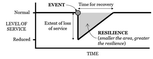
Figure 2: Resilience of route/network
Applying this to transportation routes, the cut slopes should be designed for resilience by adopting a design that has a low vulnerability to failures and closure of the route, by minimising the size and nature of failures, thus enabling the functionality of the transportation route to be restored quickly.
Classification of cut slopes in the new Design Guidelines is initially based on selecting the appropriate Importance Level of the route in order to select appropriate levels of earthquake shaking. The Importance levels (IL) proposed are those defined in AS/NZS 1170.0 supplemented by the Bridge Manual for Highways and arterial slopes. The aim of this selection has been to use the existing importance level framework in the New Zealand Standards and Bridge Manual.
A further classification of the cut slopes has been introduced to the guidelines, the Resilience Importance Category (RIC). It is recognised that the resilience expectations even for the same Importance Level of transportation route varies significantly depending on the regional context of the routes. For example IL3 routes in Christchurch or Auckland would have a lot more redundancy because of the many routes given the terrain, whereas in places like Wellington, Dunedin or Central Otago there is very little redundancy. Resilience Importance Categories have been developed to provide for incorporating the local context and resilience expectations into the design process.

Table 3: Illustration of the developments introduced by the new design guidelines for cut slope design
A four-level design approach is presented, to suit the design importance level of cut slopes. A fundamental difference of the design approach given compared to that stipulated in NZS 1170 is that the design is for resilience rather than life safety alone. The different design approaches depend on the importance level of the transportation corridor, the resilience expectations for the route and the scale and complexity of the cut slopes.
The guidance also includes assessment of suitable topographical amplification factors for typical hilly terrain where highway cut slopes are commonly formed in New Zealand, and factoring of the peak ground acceleration for derivation of equivalent pseudo-static loads for use in design.
Table 3 provides a comparison of how the proposed guidelines address difference aspects of the design compared to existing standards. The proposed approach uses a novel resilience based approach to cut slope design, and addresses significant gaps in current design guidance for cut slopes.
Closure
It is recognised that this is an area of recent research and development, and there is more research yet required to develop a good understanding of the topographical amplification issues. However, these guidelines will help bring up to date research and current knowledge to the design of transport infrastructure, at a time when major transportation infrastructure involving high cut slopes is currently happening or planned for the near future in New Zealand.
These draft guidelines provide an approach based on the research carried out, and may be converted into guidelines that are published for design use, and for eventual incorporation into design manuals such as the Bridge Manual, or into design standards.
References
Australian / New Zealand Standards (2002). Structural design actions – Part 0: General principles. June 2002.
Assimaki D, Gazetas G, Kausel E. (2005). Effects of local soil conditions on the topographic aggravation of seismic motion: Parametric investigation and recorded field evidence from the 1999 Athens Earthquake. Bulletin of the Seismological Society of America 95 (3).
Bouckovalas, G.D., Papadimitriou, A.G. (2006). Aggravation of seismic ground motion due to slope topography. 1st European Conference on Earthquake Engineering and Seismology, Geneva, 3 – 8 September, paper no. 1171.
Brabhaharan, P. (pers com) (2016). Comments following the Learning from Earthquakes mission to Japan to observe damage from the Kumamoto Earthquakes in April 2016.
Brabhaharan P., Mason D., Gkeli E. (2015). Research into Seismic Design and Performance of High Cut Slopes in New Zealand, 6th International Conference on Earthquake Geotechnical Engineering, 1-4 November 2015, Christchurch, New Zealand
Brabhaharan, Stewart D.L. (2015). Rock engineering of cut slopes to provide resilience, Muldoon’s Corner realignment, Rimutaka Hill Road, Wellington, 12 Australia New Zealand Conference on Geomechanics, 22 -2 5 February 2015, Wellington, New Zealand.
Brabhaharan, P (2006). Recent Advances in Improving the Resilience of Road Networks. Remembering Napier 1931 – Building on 75 Years of Earthquake Engineering in New Zealand. Annual Conference of the New Zealand Society for Earthquake Engineering. Napier, 10-12 March 2006.
European Committee for Standardization (2004). Eurocode 8. Design of structures for earthquake resistance. Part 1: General rules, seismic actions and rules for buildings. EN 1998-1: and Part 5: Foundations, retaining structures and geotechnical aspects. EN 1998-5. November 2004.
Hancox, G. (2015). Performance of slopes in past New Zealand earthquakes: Literature review and lessons learned from historical earthquakes. GNS Science Report CR2015/04. Prepared by Hancox, G.T., March 2015, 66 p.
Jalil, W (1992). New French seismic code orientation. Earthquake engineering. Tenth world conference. Balkema Rotterdam. Pp5867-5873.
Litchfield, N., Van Dissen, R., Sutherland, R., Barnes, P., Cox, S., Norris, R., Beavan, R., Langridge, R., Villamor, P., Berryman, K., Stirling, M., Nicol, A., Nodder, S., Lamarche, G., Barrell, D., Pettinga, J., Little, T., Pondard, N., Mountjoy, J., Clark, K. (2013). A model of active faulting in New Zealand. New Zealand Journal of Geology and Geophysics 57: 32-56.
Ministry of Business Innovation and Employment and New Zealand Geotechnical Society (2016). Guidelines for Earthquake Geotechnical Practice in New Zealand, Module 1: Overview of the Guidelines. March, 2016.
New Zealand Transport Agency (2014). Bridge Manual. Third edition. Wellington, New Zealand.
New Zealand Standards (2004). Structural Design Actions. Part 5: Earthquake Actions, New Zealand. December 2004.
Opus International Consultants (2012). Wellington Region Road Network Earthquake Resilience Study. Risk Study Report. Prepared by Brabhaharan, P and Mason, D for the NZ Transport Agency, Wellington City Council, Hutt City Council, Upper Hutt City Council, Porirua City Council and Kapiti Coast District Council. Report No 2012-21. August 2012.
Oyarzo-Vera, C.A. McVerry, G.H., Ingham, J.M. (2012). Seismic zonation and default suite of ground-motion records for time-history analysis in the North Island of New Zealand. Earthquake Spectra 28: 667-688.
Rouvray, B., Toh, J.C.W., Cammack, R., Estrada, B. (2015). Performance based geotechnical design of a seismically resilient motorway: The Transmission Gully Project, New Zealand. 6th International Conference on Earthquake Geotechnical Engineering, Paper No. 324, 9 p.
Southern California Earthquake Centre (2002). Recommended procedures for implementation of DMG Special Publication 117 guidelines for analysing and mitigating land slide hazards in California. Edited by Blake, TF, Hollingsworth, RA and Stewart, JP. p110 plus appendices.
Stirling, M., McVerry, G., Gerstenberger, M., Litchfield, N., Van Dissen, R., Berryman, K., Barnes, P., Wallace, L., Villamor, P., Langridge, R., Lamarche, G., Nodder, S., Reyners, M., Bradley, B., Rhoades, D., Smith, W., Nicol, A., Pettinga, J., Clark, K., Jacobs, K. (2012). National seismic hazard model for New Zealand: 2010 Update. Bulletin of the Seismological Society of America 102: 1514-1542.
Toh, J.C.W., Swarbrick, G.E. (2015). The Transmission Gully project: Method for assessing seismic stability of large rock cuts in steep terrain, considering topographic amplification. 6th International Conference on Earthquake Geotechnical Engineering, Paper No. 323, 8 p
